Everest Base Camp Trek By Road Trip - 15 Days Itinerary and Cost

8 reviews
Hiking trail during Everest Base Camp Trek by road trip in Nepal
Quick Overview
Duration15 Days
Trip GradeModerate
CountryNepal
Maximum Altitude5,545m
Group Size2-20
StartsKathmandu
EndsKathmandu
ActivitiesTrekking
Best TimeSpring and Autumn

The road to Everest Base Camp begins long before the mountains. It begins on the winding highway east of Kathmandu, where terraced rice fields give way to pine forests and the air slowly sharpens with altitude. Most trekkers fly to Lukla. You will drive, and that changes everything.

This 15-day journey takes you overland from Kathmandu to Salleri, through some of Nepal's most beautiful and least-visited hill country. By the time you lace up your boots at the trailhead, you will have already watched the landscape transform from subtropical valley to high Himalayan ridge. No white-knuckle Lukla landing. No flight delays that can cost you days of your trek. Just a steady, scenic approach that lets your body adjust naturally.

From Phakding, you join the classic Everest Base Camp route. The trail crosses suspension bridges over the Dudh Koshi River, climbs through Sherpa villages where prayer flags snap in the wind, and passes through teahouses where you will eat dal bhat with people from every corner of the world.
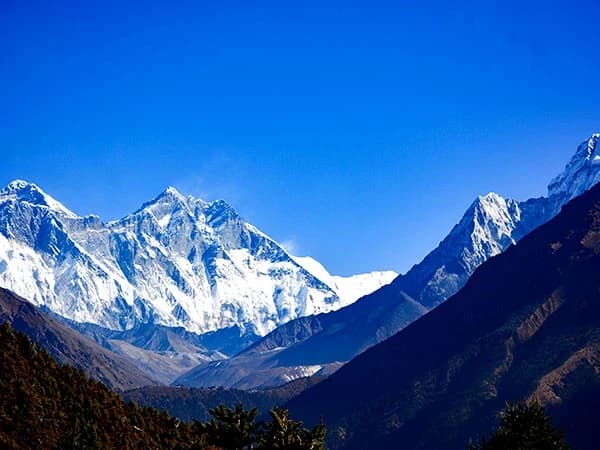
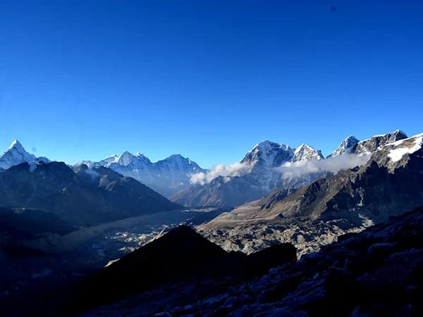
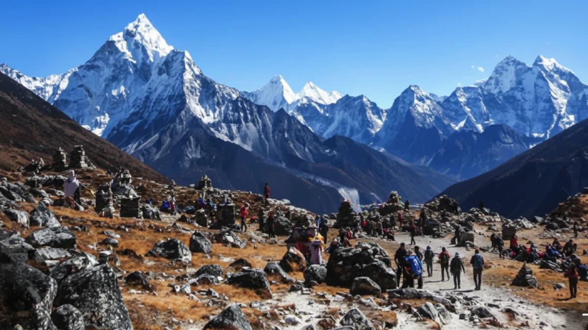
Acclimatisation days at Namche Bazaar and Dingboche are built into every itinerary. These are not wasted days. In Namche, you hike to the Everest View Hotel for your first clear sight of the summit. In Dingboche, you walk above the village to a ridge where Island Peak and Makalu fill the horizon. Your guides have walked this trail hundreds of times. They know when to push, when to rest, and when to stop for tea at a lodge with the best view you will see all week.

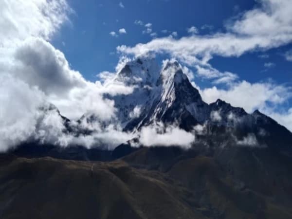
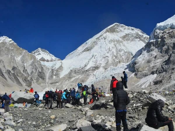
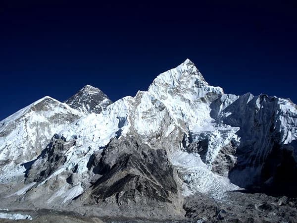
The final push takes you across the Khumbu Glacier to Everest Base Camp at 5,364 metres. The next morning, you climb Kala Patthar (5,545m) before sunrise to watch the first light hit Everest's summit pyramid. Trekkers who have been to both will tell you that Kala Patthar is the moment they came for.

The return follows the same trail south, then a private vehicle carries you back to Kathmandu. Fifteen days, no flights, no cancellations, and roughly $200-300 less than the Lukla route.

What Makes This Trek Unforgettable

  • Skip the Lukla flight entirely. No cancellations, no delays, no Manthali detour.
  • Drive through Nepal's stunning lower hill country before the trek begins.
  • Trek the full classic route: Namche Bazaar, Tengboche Monastery, Dingboche, Lobuche, Gorak Shep.
  • Stand at Kala Patthar (5,545m) at sunrise for the most famous view of Everest.
  • Walk across the Khumbu Glacier to Everest Base Camp (5,364m).
  • Two built-in acclimatisation days for safety and comfort.
  • Visit ancient monasteries at Tengboche and Pangboche.
  • Save $200-300 per person compared to the Lukla flight route.

15-Day Everest Base Camp Road Trek Overview

We begin in Kathmandu, where you board a private vehicle and drive east through the stunning scenery to Salleri and then to the trailhead. This is when the real adventure begins. From Phakding, a two-day hike takes you right to the main Everest trail at Namche Bazaar, the busy trading town that has served as the gateway to Khumbu for centuries.

You proceed to Monjo, the official entry point to Sagarmatha National Park. From there, the trail climbs through magnolia and pine forests until you reach Namche Bazaar. We spend a full day acclimatising here, and again at Dingboche. These breaks are essential for getting accustomed to the higher elevation.

Above Dingboche, the trees disappear and the landscape turns into harsh alpine terrain. The final push is a challenging yet rewarding climb to Gorak Shep, where two great moments converge: the trek to Everest Base Camp (5,364m) and the pre-dawn climb to Kala Patthar (5,545m) for the most famous sunrise in the Himalayas.

We return the same way, passing through Pheriche and Namche Bazaar. Your vehicle will be waiting to drive you back to Kathmandu in comfort. That is the end of your adventure with The Everest Holiday, but most trekkers tell us the memories stay with them for the rest of their lives.

Reminder

For a smooth and easy start, we recommend arriving in Kathmandu by 4 PM the day before departure. This gives you time for a final gear check, a trip briefing with your guide, and to make sure you have everything you need. Read our guide on arriving at Kathmandu airport for what to expect.

Online Briefing

Think of this as our first coffee together before the trip. We will walk you through what to bring, what each day looks like, and answer any questions. After you book, we will send you a couple of times when we can talk. Our trek itinerary does not include your hotel stay in Kathmandu, so during the briefing, please let us know your preferences, budget, and standard of hotel. We will arrange it for you.

Ground Transportation

This is a road trek. There are no flights, no Lukla, no Manthali airport transfers. Your journey to the trailhead and back is entirely by ground vehicle. Budget trekkers travel by local bus or shared jeep. Standard trekkers get a private tourist vehicle. Luxury trekkers ride in a luxury private vehicle. The drive from Kathmandu to Salleri takes 8-9 hours through beautiful hill country.

Note to Trekkers

Experience the Himalayas on your terms. We create personal, intimate treks for groups of two or more. Whether you select our Budget, Standard, or Luxury package, your adventure will be exclusively for you and your companions, for a comfortable and personal journey from start to finish.

Kathmandu Accommodation

Your hotel in Kathmandu is not included in the trek package. During the online briefing before your trek, we will ask about your preferences and budget, whether you want a simple guesthouse or a five-star hotel, and help you arrange it. Your trek package begins when you leave Kathmandu for the mountains.

Compare Our Three Packages

  Budget Standard Luxury
Price from USD 1,133 USD 1,693 USD 2,999
Transport Local bus/shared jeep Private tourist vehicle Luxury private vehicle
Meals Choose your own (approx. USD 15-25/day) 3 meals + tea + fruits + 2L water daily All meals + all drinks anytime (except alcohol)
Room Shared teahouse Private twin w/ bathroom Private deluxe w/ bed heater
Porter Not included 1 per 2 trekkers 1 per trekker (carry nothing)
Guide 1 guide, assistant at 8+ 1 guide per 6, assistant at 6+ 1 guide per 2 trekkers
SIM data SIM only Limited data Unlimited data
Best for Backpackers and independent travellers Comfort trekkers, couples, families Premium experience seekers

Himalayas for Every Budget — same expert guides, same safety, three comfort levels.

Your Trek, Our Family

Shreejan Simkhada comes from three generations of Himalayan expertise. His grandfather arranged expeditions in the 1960s. His father held senior positions at the Nepal Tourism Board and Nepal Mountaineering Association. Shreejan personally designs every itinerary and hand-picks the guide for your group.

Your guide will be one of our Nepal government well-trained professionals, qualified mountaineering experts with years of Himalayan experience. Shreejan briefs every guide personally before your trek begins.

Have a question right now? WhatsApp Shreejan directly: +977 9810351300. No sales team. No chatbot.

Our Credentials

  • 197+ TripAdvisor Reviews, 4.9 out of 5 stars, TripAdvisor Travellers Choice 2024
  • 108+ Google Reviews, 4.9 out of 5 stars
  • TAAN Certified, Member #1586, Government Reg: 147653/072/073
  • Secure 10% Deposit via Himalayan Bank
  • Himalayas for Every Budget, breakfast, lunch, and dinner throughout the trek
  • Three Generations, family guiding in the Himalayas since the 1960s

Solo Trekkers Welcome

You do not need a travel partner to trek in Nepal. Most of the people who book with us come alone, and by day three on the trail, they are sharing meals, swapping stories, and watching sunrises together like old friends.

Our groups are kept small (2-20 people) so you get a personal experience, not a conveyor belt. You also have the option to book privately. If you choose to make it a public group, we will list your dates as fixed departures so other solo travellers can join you. Either way, the trek is built around you.

Difficulty: Moderate to Challenging (4/5)

You need to be comfortable walking 5-8 hours per day over uneven terrain. The road section adds scenic value but also longer travel days. Two acclimatisation days are built in at Namche Bazaar and Dingboche. Read our beginner's guide to Nepal trekking if this is your first Himalayan trek.

Difficulty

This trek is rated Moderate to Challenging. You walk 5-7 hours per day over well-maintained trails, with two rest days built in for acclimatisation. The highest point is Kala Patthar at 5,545metres. No technical climbing is required, but you should be comfortable with steep ascents and descents at altitude. The road approach from Kathmandu adds a day of driving but actually makes the trek easier on your body — you gain altitude gradually instead of flying straight to 2,860 metres at Lukla.

If you can walk 6-8 hours on uneven terrain and handle basic fitness activities like stair climbing and hiking, you are ready for this trek. Read our detailed guide on how hard EBC trek really is and how to train for it.

Trek With a Purpose — Changing the World, One Step at a Time

A portion of every booking supports the Nagarjun Learning Center, founded by our family in 2019. Today, 70 children receive free education and hot meals daily at our flagship centre in Saldum Village, Dhading District. We have also provided free medical care to 600+ people and reached 275+ women through support programmes. The centre is verified and listed on the UN Partner Portal. When you trek with us, you are not just climbing mountains, you are building futures. Trek With a Purpose — Changing the World, One Step at a Time.

What Trekkers Say About This Trek

"Our guide made sure we acclimatised properly. I never felt rushed. The teahouses were comfortable and the food was surprisingly good at altitude."

— Google Review, 5 stars

Read all 320+ reviews →

Short Itinerary
Day 01: Early morning drive from Kathmandu to Salleri/Phaplu (2,413m/ 7,915ft.), usually taking around 8 to 9 hours with an elevation change of 819m – 3571ft.
Max Altitude: 2,413m/ 7,915ft.
Day 02: Early morning, taking a local jeep 5 to 6 hours drive to Thamdanda (2,300m/ 7,546ft.), after that trek to Paiya (2,730m/ 8,956ft.), usually around 1 hour with a total elevation change 400m – 1410ft.
Max Altitude: 2,730m/ 8,956ft.
Day 03: After Breakfast, the trek begins from Paiya to Phakding (2,610m/ 8,562ft.), usually around 5-6 hours with a total elevation change of 120 m – 394 ft.
Max Altitude: 2,610 m/ 8,562ft.
Day 04: After crossing from Phakding to Namche Bazaar (3,440m/ 11,285ft.), usually around 5-6 hours with a total elevation change of 830 m – 2724 ft.
Max Altitude: 3,440m/ 11,285ft.
Day 05: Acclimatisation Day Namche Bazaar
Max Altitude: 3,440 m/ 11,285ft.
Day 06: Trek from Namche Bazaar to Tengboche (3,855m/ 12,850ft.), usually around 5-6 hours with a total elevation change of 415 m – 1375 ft.
Max Altitude: 3,855m/ 12,850ft.
Day 07: Trek 11 km/ 6.8 miles walk from Tengboche to Dingboche (4,410m/ 14,290ft.), usually around 5-6 hours with a total elevation change of 505 m – 1440ft.
Max Altitude: 4,410m/ 14,290ft.
Day 08: Acclimatisation at Dingboche.
Max Altitude: 4,410m/ 14,290ft.
Day 09: Trek from Dingboche to Lobuche (4,910m/ 16,175ft.), usually around 5 hours with a total elevation change of 570 m – 1885ft.
Max Altitude: 4,910m/ 16,175ft.
Day 10: Early morning trek start to Gorak Shep (5,185m/ 17,010ft.) and visit Everest Base Camp (5,364m/ 17,594ft), usually around 5-6 hours with a total elevation change of 179 m – 584 ft.
Max Altitude: 5,185m/ 17,010ft.
Day 11: After breakfast, the hike starts to Kala Patthar (5545m/ 18192ft.) then Trek to Pheriche (4,280m/ 14,042ft.), usually around 7-8 hours with a total elevation change of 1265 m – 4150 ft.
Max Altitude: 4,280m/ 14,042ft.
Day 12: Trek from Pheriche to Namche Bazaar (3,440m/ 11,286ft.), usually around 8-9 hours with a total elevation change of 840 m – 2756 ft.
Max Altitude: 3,440m/ 11,286ft.
Day 13: Trek from Namche Bazaar to Chheplung (2,660m/ 8,727ft.), usually around 1-2 hours with a total elevation change of 780 m – 2559 ft.
Max Altitude: 2,660m/ 8,727ft.
Day 14: Trek starts to Surke/Thamdanda with end and drives to Phaplu (2,413m/ 7,915ft.), usually around 5-6 hours.
Max Altitude: 2,413m/ 7,915ft.
Day 15: Drive to Kathmandu is the last day of the trek, usually around 10 – 12 hours(1,400m/ 4,593ft.)
Max Altitude: 1,400m/ 4,593ft.
Expand
Detailed Itinerary
Day 01:

The alarm rings early in Kathmandu, but there is no groggy reluctance today. Your bags are loaded onto the roof of a private jeep, the driver checks his tires one final time, and you pull away from the hotel into streets that are only just waking up. Fruit sellers arrange pyramids of tangerines under bare bulbs. A temple bell sounds somewhere behind a wall of brick and carved wood. Then the city thins, the ring road falls behind, and Nepal opens up.

This is the road to Everest, and it is nothing like the thirty-minute flight to Lukla that most trekkers take. Where they see clouds from a window, you see the country change beneath your wheels. The first hours follow the Arniko Highway east through the Kathmandu Valley's terraced outskirts, past schoolchildren in blue uniforms walking along dusty verges and women spreading rice on woven mats to dry in the sun. The air smells of woodsmoke and diesel, and the two scents will become oddly comforting by the end of the trip.

After Lamosangu, the road begins to climb and the landscape shifts dramatically. Broad river valleys give way to tighter gorges where the Tamakoshi and its tributaries have carved through rock over millennia. The tarmac comes and goes. Your driver navigates sections of gravel with a calm, practiced hand, honking twice on blind corners in the universal language of Nepali mountain roads. Waterfalls appear without warning, slicing across cliff faces and sometimes across the road itself, leaving the windscreen briefly blurred before the wipers catch up.

Lunch is taken at a roadside bhatti, one of the small family-run eateries that line every major route in Nepal. Dal bhat is the obvious choice. The lentil soup is thinner than the Kathmandu tourist version, the rice is local and fragrant, and the achar has a smoky heat that makes your eyes water. Your guide will tell you that dal bhat is not just food on a trek but fuel and that you will come to crave it by day five. He is not wrong.

The afternoon brings the best section of the drive. The road climbs through forests of rhododendron and pine towards the Solukhumbu district, and on a clear day the first distant white peaks appear on the northern horizon. They look impossibly high, impossibly far away, and yet every kilometer of rough road brings them closer. The villages here are smaller. Prayer flags stretch between rooftops. Mani walls, those long stone structures carved with Buddhist mantras, begin to appear at the edges of settlements, a sign that you are entering Sherpa country.

You reach Salleri, the district headquarters of Solukhumbu, as the light turns golden. At 2,413 meters, the air already feels different, thinner and cooler, carrying the scent of pine resin. Your lodge is simple but warm, and dinner is served in a common room heated by a wood-burning stove. Other trekkers who flew to Lukla this morning are already at Phakding. You are here, eight hours south, having earned every meter of altitude the slow way. It does not feel like a disadvantage. It feels like the proper beginning of something significant. Your body has had a full day to start adjusting to the altitude, and your mind has had time to leave the city behind. Tomorrow the walking begins.

View the full interactive route map: Everest Base Camp by Road — 15-Day Route Map

Max Altitude: 2,413m/ 7,915ft.Meals: Breakfast, Lunch, and DinnerAccommodation: Local Teahouse or LodgeDuration: 9-10 HoursDistance: 264km/ 164 miles
Day 02:

The morning starts with a short drive from Salleri through Phaplu, a town with a small airstrip that once served as the main gateway to the Everest region before Lukla took over. The road winds through a landscape of terraced fields and scattered farmsteads, and your guide points out the monastery above Phaplu, where the young Sherpa monks study. The jeep drops you at Thamdanda, and from here the trek begins in earnest.

Stepping out of the vehicle and onto the trail is a small but memorable shift. The engine noise fades. The sounds that replace it are birdsong, wind through rhododendron branches, and the distant rush of a river far below. Your boots find the packed earth of a path that has been walked for centuries by traders, monks, and farmers long before the word "trekking" existed in any language. The trail here in the lower Solukhumbu is wider and gentler than what lies ahead, winding through forests of oak and magnolia with occasional clearings where villages sit on sunny ridgelines.

The walking today is moderate, a good introduction for legs that spent yesterday folded into a jeep. The trail passes through small settlements where life moves at a pace that Kathmandu has long forgotten. Women card wool on wooden porches. Children chase each other around a chautara, the stone resting platform shaded by a pipal tree that appears at intervals along every trail in the hills. A man leads a train of dzopkyos, the yak-cow crossbreeds that carry loads at these middle altitudes, their bells producing that hollow, melodic clank that will become the soundtrack of the coming days.

Lunch is taken at a teahouse where the owner's daughter brings you sweet milk tea without being asked. The menu is handwritten on cardboard and offers dal bhat, fried rice, and noodle soup. Your guide recommends the dal bhat. He will always recommend the dal bhat. He is always right. The portions are generous, and you eat sitting on a wooden bench in a patch of sunlight, watching clouds build over the ridge to the north.

The afternoon section descends through forest into the village of Paiya, which sits at 2,730 meters in a quiet valley that most Everest trekkers never see. This is one of the genuine advantages of the road route. While the Lukla trail is busy from day one, this southern approach passes through communities that receive only a handful of foreign visitors each week. The lodges are basic but clean, and the welcome is warm precisely because it is not routine. The lodge owner in Paiya may sit with you after dinner, asking where you are from and telling you about his son who works as a cook on expeditions. These conversations, unhurried and genuine, are worth more than any mountain view.

By evening, your legs carry a pleasant tiredness. The altitude is still modest, and sleep comes easily. Through the window you can see stars in a density that is simply not possible in any city, the Milky Way a pale river overhead. Tomorrow the trail joins the classic Everest route, and the character of the trek will change. Tonight, though, you are in the quiet south, and the mountains are patient.

Max Altitude: 2,730m/ 8,956ft.Meals: Breakfast, Lunch, and DinnerAccommodation: Local Teahouse or LodgeDuration: 5-6 hours drive and 1-2 hours hikeDistance: 75 km off-road and 4-5 Km hike
Day 03:

The trail from Paiya heads north through increasingly rugged terrain, and today marks the transition from the quiet southern approach into the main artery of the Everest region. The walking is steady, five to six hours through forest and along river valleys, and the path gains and loses altitude in the rolling pattern that defines Himalayan trekking. There are no flat days here. Every valley must be descended into and climbed out of, and the sooner you accept this, the happier your knees will be.

The morning section passes through dense forest where sunlight falls in broken columns through the canopy. Rhododendron trees, gnarled and moss-covered, arch over the trail. In spring these same trees explode into red and pink blooms that carpet the path with fallen petals, but even outside the flowering season they have a sculptural beauty, their twisted trunks telling stories of wind and time. Langur monkeys crash through the upper branches occasionally, their long tails trailing behind them like grey ropes. You hear them before you see them, a rustle and crack of breaking twigs, then a flash of silver fur against green leaves.

As the trail drops towards the Dudh Kosi River, the sound of rushing water grows from a murmur to a roar. This is the river that drains the glaciers of Everest, Lhotse, and their neighbors, and its milky turquoise colour betrays its glacial origins. You cross it on a suspension bridge that sways gently underfoot, prayer flags strung along its cables snapping in the updraft from the gorge below. Your guide walks across without holding the rails, a casual confidence that comes from a thousand crossings. You grip the wire and try not to look down. You look down anyway. The river is beautiful and terrifying in equal measure.

By midday the trail merges with the route from Lukla, and suddenly there are more people. Trekkers with clean boots and fresh faces are heading north from their morning flight, porters carry impossible loads secured with namlo headstraps, and the occasional dzopkyo train forces everyone to step aside. This is the main Everest highway, and it has been busy since Edmund Hillary first walked it in 1953.

You reach Phakding in the afternoon, a strung-out village along the river at 2,610 meters. The lodges here are more established than those on the southern trail, with menus in English and hot showers available for a few hundred rupees. Your guide checks you into a lodge he knows well, one where the rooms catch the afternoon sun and the kitchen serves proper garlic soup, which at altitude becomes something close to medicine. The village has a relaxed atmosphere. Trekkers sit on lodge terraces writing in journals or studying maps of the days ahead. Sherpa guides gather in the kitchen, laughing and talking in their own language over cups of tea. You are two days of walking from the road, and already the rhythm of the trail has settled into your body. Wake, walk, eat, rest, sleep. It is a good rhythm.

Max Altitude: 2,610 m/ 8,562ft.Meals: Breakfast, Lunch, and DinnerAccommodation: Local Teahouse or LodgeDuration: 5-6 hoursDistance: 10-13 KM/ 8 miles
Day 04:

Today is the day that separates the casual walkers from the committed trekkers. The trail from Phakding to Namche Bazaar gains over 800 meters of altitude in five to six hours, and the final section is a relentless uphill that has humbled stronger legs than yours. But it is also one of the most rewarding days on the entire trek, and by evening you will understand why Namche has been the beating heart of the Everest region for centuries.

The morning begins gently enough. The trail follows the Dudh Kosi River northward, crossing it twice on long suspension bridges that swing high above the water. The gorge is deep here, the valley walls rising steeply on both sides, and the forest is thick with pine and blue pine, whose needles release a clean, sharp scent when the morning sun warms them. Prayer wheels line the trail at intervals, copper cylinders set into stone housings, and your guide spins each one as he passes them. Clockwise, always clockwise. You start doing the same without thinking about it.

At the village of Jorsale, you enter the Sagarmatha National Park, the protected area that covers the entire upper Khumbu. The checkpoint here requires your permits, and there is usually a short wait while the soldiers record your details in a ledger. Just beyond Jorsale, the trail crosses the river one final time on a high bridge, and then the climb to Namche begins in earnest.

The next two hours are steep. There is no gentle way to describe it. The trail switchbacks up through forest on the side of a ridge, gaining altitude with every step, and the air feels noticeably thinner than it did at breakfast. Your breathing deepens. Your pack feels heavier. The temptation is to push through quickly, but your guide sets a slow, deliberate pace, stopping frequently. He tells you that this hill has caused more altitude problems than any other section of the trek, simply because people rush it. Walk slowly. Drink water. Breathe. There is a rhythm to climbing at altitude, and today is where you learn it.

Roughly halfway up the climb, if the sky is clear, you get your first proper view of Everest. It appears above the ridge to the northeast, a dark pyramid with a plume of snow streaming from its summit. It looks surprisingly modest from here, almost hidden behind the closer bulk of Lhotse and Nuptse. Your guide stops and points. That is Sagarmatha, he says, using the Nepali name. Every trekker who has ever walked this hill has paused at this same spot and stared. The mountain does not disappoint.

Namche Bazaar reveals itself suddenly as the trail crests the ridge and turns into a natural amphitheater carved into the mountainside. The town is built in a horseshoe shape, its whitewashed buildings and blue roofs stacked up the slopes like seats in a stadium. There are bakeries selling apple pie, shops selling down jackets, and teahouses with wood-burning stoves and surprisingly strong WiFi. At 3,440 meters, it is the last real town before the wilderness of the upper Khumbu, and it has everything you need. Tonight you eat well, sleep in a proper bed, and let your body begin the serious work of adapting to the thin air. Tomorrow is a rest day, and Namche has plenty to offer.

Max Altitude: 3,440m/ 11,285ft.Meals: Breakfast, Lunch, and DinnerAccommodation: Local Teahouse or LodgeDuration: 5-6 hoursDistance: 12 km/ 7.4miles
Day 05:

A rest day at Namche Bazaar is not really a rest day. The term is misleading. What it actually means is an acclimatisation day, and your guide will insist that you spend the morning climbing higher before returning to sleep at the same altitude. This is the golden rule of high-altitude trekking: climb high, sleep low. Your body needs time to produce more red blood cells, and the best way to encourage that process is to give it a taste of what lies ahead.

The most popular acclimatisation hike from Namche Bazaar climbs to the Everest View Hotel at Syangboche, a modest airstrip and viewpoint at around 3,800 meters. The trail is well marked and takes roughly ninety minutes up and an hour down. The views from the top are extraordinary. On a clear morning, which is most mornings in the pre-monsoon season, you can see Everest, Lhotse, Ama Dablam, Thamserku, and Kongde from a single vantage point. Ama Dablam in particular is stunning from here, its fluted ice ridges catching the early light like cut glass. Many trekkers say it is the most beautiful mountain they have ever seen. They are not exaggerating.

An alternative hike heads to the national park visitor center above the town, where there is a small museum dedicated to Sherpa culture and the history of Everest expeditions. The displays are simple but moving. Photographs of early climbers in wool and leather stand beside modern images of Sherpa guides who have summited ten, fifteen, twenty times. There is a replica of the oxygen apparatus used by Hillary and Tenzing in 1953, a contraption that looks barely adequate for a hospital, let alone the death zone. Your guide may know some of the climbers in the photographs personally. The Khumbu Sherpa community is small, and nearly every family has someone who works on the mountain.

The afternoon is free, and Namche rewards exploration. The Saturday market, if your timing is right, draws traders from across the region. Tibetan merchants sell jewelry and singing bowls. Local farmers bring potatoes, eggs, and dried yak cheese that is so hard it must be sucked for twenty minutes before it becomes chewable. The bakeries are a genuine highlight. After days of dal bhat, a slice of fresh apple pie with a cup of real coffee feels like an unreasonable luxury. The Namche bakeries have been fuelling trekkers and climbers for decades, and they know exactly what a tired body craves.

Wander the narrow lanes between buildings and you find prayer wheels, small monasteries, and shops selling everything from trekking poles to Snickers bars at altitude-adjusted prices. Internet cafes offer the chance to send a message home, though the connection is slow and the per-megabyte cost is steep. Most trekkers send a quick message, post a photograph, and then put the phone away. The mountains are better without a screen between you and them.

By evening, the sun drops behind the western ridge, and the temperature falls sharply. You return to the lodge and sit near the stove, drinking lemon tea and talking with other trekkers about the days ahead. Everyone has the same questions. How hard is the climb to Lobuche? Is Kala Patthar worth the early start? What is base camp actually like? Your guide answers patiently, having heard these questions a thousand times. Get some sleep, he says. Tomorrow we go higher.

Max Altitude: 3,440 m/ 11,285ft.Meals: Breakfast, Lunch, and DinnerAccommodation: Local Teahouse or Lodge
Day 06:

The trail from Namche Bazaar to Tengboche is one of the most scenic sections of the entire Everest trek. It begins with a long, gradual traverse along the side of the valley, contouring high above the Dudh Kosi River with views that make you stop every few minutes. Ama Dablam dominates the skyline ahead, growing larger and more detailed with every hour. Its south-west ridge, the one most climbers use, is visible as a sharp line of snow and rock that looks vertical from this angle. To the right, Everest and Lhotse peer over the intervening ridges, and behind you Thamserku's ice-fluted face catches the morning light.

The trail drops to the river at Phunki Tenga, a small settlement in the valley floor where a water-driven prayer wheel spins endlessly in the stream. The descent is steep and fast, and your guide reminds you to save your knees for the climb ahead. Phunki is a good place for tea. The lodge sits beside the river, and you can hear the prayer wheel's wooden axle creaking as it turns, a sound that seems to belong to a much older world.

From Phunki, the trail climbs steeply through dense rhododendron forest towards Tengboche. This ascent is demanding, gaining roughly 600 meters over two hours, and the altitude is beginning to make itself felt. At 3,500 meters and above, every uphill section requires a conscious effort to slow down and breathe deeply. Your guide walks ahead, setting a pace that feels frustratingly slow on the flat but perfectly judged on the steep sections. Trust the pace. The trekkers who overtake you on the hill will be the ones sitting by the trail gasping half an hour later.

Tengboche announces itself with the sound of horns. The monastery here is the spiritual center of the Khumbu, and if you arrive during afternoon prayers, the deep vibration of the dungchen, the long Tibetan horns, rolls across the clearing like a physical force. The monastery sits on a forested ridge at 3,855 meters, surrounded by the most dramatic mountain panorama in the Himalayas. Ama Dablam rises directly to the east. Everest, Lhotse, and Nuptse fill the northern skyline. The clearing in front of the monastery is a natural amphitheater, and the mountains are the performance.

If the monastery is open, step inside. The interior is dim and warm, lit by butter lamps whose flickering light illuminates painted murals and gilded statues. Monks sit in rows, chanting in low voices, their maroon robes bright against the dark wood of the benches. The air smells of juniper incense and yak butter, a combination that will forever after remind you of this place. Photography is not permitted inside, which is as it should be. Some things are better held in memory than on a screen.

The lodge at Tengboche is comfortable by trekking standards. The dining room has large windows facing the mountains, and dinner is eaten as the last light turns the snow peaks from white to gold to pink to grey. The temperature drops fast after sunset at this altitude, and you will want your down jacket for the evening. Tomorrow the trail climbs above the treeline, and the landscape changes from forest to alpine scrub. The gentle green of the lower valleys is behind you now. Ahead, the world is rock, ice, and sky.

Max Altitude: 3,855m/ 12,850ft.Meals: Breakfast, Lunch, and DinnerAccommodation: Local Teahouse or LodgeDuration: 5-6 hoursDistance: 10 km/ 6.2 miles
Day 07:

Leaving Tengboche, the trail descends through the last significant forest you will see for days. The rhododendrons give way to birch and juniper as you drop into the valley of the Imja Khola, crossing the river on a suspension bridge at Pangboche. Pangboche is one of the oldest Sherpa settlements in the Khumbu, and its monastery is said to predate Tengboche by several centuries. The village sits on a sunny terrace above the river, its stone-walled fields divided by low walls where yaks graze on stubble. If you look closely at the houses, you will notice that the window frames are painted in bright colours, blue, red, and green, a tradition that is said to ward off evil spirits.

Above Pangboche, the landscape transforms. The treeline falls behind, and the valley opens into a wide, wind-scoured corridor flanked by enormous peaks. The vegetation is now low scrub, tough grasses, and the occasional hardy bush clinging to the rocky soil. The colours shift from green to brown and grey, with patches of pale yellow where dried alpine grass catches the light. It is a stark, beautiful landscape, utterly unlike anything below, and the sense of altitude is no longer something you merely feel in your lungs. You can see it. The world has been stripped to its essentials.

The trail climbs gradually but persistently towards Dingboche, and every hundred metres of elevation gained is noticeable. Conversations become shorter. Laughter requires more breath than you expect. Your guide walks steadily, occasionally pointing out features of the landscape. That dark streak on Lhotse's face is the Lhotse Couloir, he says, one of the most dangerous routes in Himalayan climbing. The ice towers above Imja Tse are the remnants of a glacier that has been retreating for decades. He carries these facts lightly, the way someone carries knowledge that is simply part of their world.

Dingboche sits at 4,410 metres in a broad valley beneath the towering wall of Lhotse. The village is a collection of stone lodges surrounded by dry-stone walls built to protect potato fields from the wind. The wind here is significant. It funnels down the valley from the glaciers above, and by afternoon it can be strong enough to make walking uncomfortable. Most trekkers arrive by early afternoon and spend the rest of the day resting, drinking tea, and playing cards in teahouses with steamed-up windows.

Altitude effects are common at Dingboche. Mild headaches, disrupted sleep, and a general feeling of sluggishness are normal responses to the thin air, and your guide will check in with you about your symptoms. The key is hydration, rest, and honesty. If you feel unwell, say so. The mountains will wait. Dinner tonight is early, as it is at every stop above 4,000 metres. Garlic soup is on the menu again, and at this altitude it genuinely seems to help. By eight o'clock the lodge is quiet. Tomorrow is another acclimatisation day, and your body needs every hour of rest it can get.

Max Altitude: 4,410m/ 14,290ft.Meals: Breakfast, Lunch, and DinnerAccommodation: Local Teahouse or LodgeDuration: 5-6 hoursDistance: 11 km/ 6.8 miles
Day 08:

The second acclimatisation day is perhaps more important than the first. At 4,410 metres, your body is working hard to adjust, producing additional red blood cells, increasing your breathing rate, and making a hundred other invisible changes that allow you to function in air that contains roughly sixty percent of the oxygen available at sea level. Skipping this rest day would be reckless. Your guide knows this, and he will not let you push ahead regardless of how good you feel.

The morning hike from Dingboche heads uphill towards Nangkartshang Peak, a rocky viewpoint at approximately 5,083 metres. You do not need to reach the summit. Even climbing to 4,800 metres and returning to Dingboche is enough to trigger the physiological response your body needs. The trail is steep and rocky, and at this altitude every step requires deliberate effort. You will count your breaths. Ten steps, stop, three breaths. Ten steps, stop, three breaths. This is the rhythm of the high Himalaya, and there is no shortcut.

The views from the ridge above Dingboche are breathtaking in the most literal sense. To the north, Lhotse's massive south face fills the sky, a wall of dark rock and ice that rises nearly 3,000 metres above the valley floor. To the east, the peaks of Makalu and Baruntse mark the border with the Makalu-Barun National Park. Island Peak, properly called Imja Tse, stands to the south-east, its summit pyramid looking deceptively accessible from this angle. Your guide may mention that he has climbed it several times, leading clients up the fixed ropes to the top. At 6,189 metres, it is one of Nepal's most popular climbing peaks, and many trekkers return to attempt it after completing the base camp trek.

Back in the village by lunchtime, the afternoon stretches ahead with nothing required of you. This is a rare gift on a trek, and you should accept it fully. Read a book. Write in your journal. Sit in the sun outside the lodge and watch the clouds build over Ama Dablam. Some trekkers find the enforced rest difficult, especially those who are fit and feel fine. But fitness and acclimatisation are different things. A marathon runner can develop altitude sickness just as easily as a casual walker. The body operates on its own schedule up here, and patience is not optional.

The lodge at Dingboche has a common room where trekkers from different groups mix easily. There is something about shared discomfort that breaks down social barriers. You will meet teachers from Australia, retired engineers from Germany, students from South Korea, and a surprising number of solo travellers who came to Nepal on a whim. Stories are exchanged over cups of ginger tea. Trail conditions, lodge recommendations, and the universal complaint about the price of chocolate bars at altitude. By evening, the wind picks up again, rattling the tin roofs of the lodges. You pull your sleeping bag tight and think about tomorrow. The trail to Lobuche is where the trek becomes truly high altitude, and everything after this point is above 4,900 metres. Rest now. You have earned it.

Max Altitude: 4,410m/ 14,290ft.Meals: Breakfast, Lunch, and DinnerAccommodation: Local Teahouse or Lodge
Day 09:

The morning walk out of Dingboche climbs gradually up the valley towards Thukla, a small cluster of lodges at the base of the terminal moraine of the Khumbu Glacier. The landscape is now entirely alpine, all rock and scree and thin brown grass. There are no trees, no bushes taller than your ankle, and the sky seems enormous. The colours are muted, greys and browns and dusty yellows, but the light at this altitude gives everything a sharp, crystalline clarity that photographs never quite capture.

Above Thukla, the trail climbs steeply up the moraine wall, and this short section is one of the hardest of the entire trek. It is only about forty-five minutes of climbing, but at nearly 4,800 metres the gradient is punishing. Your legs burn, your lungs heave, and you stop every twenty paces to catch your breath. There is no shame in this. Everyone stops. The porters stop. The guides stop. The yaks stop. Altitude is the great equaliser.

At the top of the moraine, the trail levels out and passes through the memorial area known as Thukla Pass or Chukpo Lari. Stone cairns and memorial plaques are scattered across the rocky plateau, each one dedicated to a climber or Sherpa who died on Everest or its neighbouring peaks. The memorials for the 2014 icefall disaster and the 2015 earthquake are particularly moving, rows of carved stones bearing names that are still spoken with respect in every lodge in the Khumbu. Your guide will walk through quietly. He may know some of the names. The Sherpa climbing community carries its losses close, and these stones are not abstractions to them.

Beyond the memorials, the trail traverses a wide, flat valley with the lateral moraine of the Khumbu Glacier rising to the right like a wall of grey rubble. The glacier itself is hidden beneath this debris, and it looks nothing like the clean blue ice of popular imagination. It is a river of broken rock, dirty and chaotic, stretching for kilometres up the valley towards Everest. Occasionally you hear it groan, a deep, unsettling sound as the ice shifts beneath its stony blanket.

Lobuche appears ahead, a handful of lodges huddled together at 4,910 metres on the edge of the moraine. The lodges are basic. The rooms are cold. The food is simple, and everything costs more than you expect because every item has been carried here on the back of a human being or a yak. None of this matters. You are at nearly 5,000 metres, higher than any point in the European Alps, and tomorrow you walk to Everest Base Camp. The excitement in the lodge dining room is palpable. Strangers who have been walking the same trail for days compare notes, share trail mix, and talk about the weather forecast. A clear morning tomorrow means views. A cloudy one means disappointment. Your guide checks his phone, scrolling through a Nepali weather app, and nods. It looks good, he says. Sleep early.

Max Altitude: 4,910m/ 16,175ft.Meals: Breakfast, Lunch, and DinnerAccommodation: Local Teahouse or LodgeDuration: 5-6 hoursDistance: 10 km/ 6.2 miles
Day 10:

This is the day you came for. The alarm sounds at five in the morning, and you dress in the dark, layering thermals and fleece and down with fingers that fumble in the cold. Breakfast is quick, hot porridge and sweet tea, eaten by headlamp in a dining room where every face wears the same expression of nervous anticipation. Then you step outside into a cold so sharp it takes your breath away. The stars are still out, impossibly bright at this altitude, and the peaks around you are dark silhouettes against a sky that is just beginning to lighten in the east.

The trail from Lobuche to Gorak Shep takes roughly three hours across rocky, undulating terrain. The path follows the edge of the Khumbu Glacier's lateral moraine, and the glacier itself makes its presence known through occasional creaks and groans from beneath its covering of debris. Pumori rises to the left, its summit pyramid catching the first direct sunlight of the day, turning from grey to gold in the space of a few minutes. Nuptse's enormous wall dominates the right side of the valley. You are walking through a corridor of giants.

Gorak Shep, at 5,164 metres, is the last settlement before base camp. It sits on a sandy flat beside a frozen lake, and the lodges here are the highest permanent structures on the trail. You drop your main pack, fill your water bottles, and head north towards Everest Base Camp with only a daypack. The trail is rough, crossing the moraine itself now, a landscape of ice towers, boulder fields, and grey sand that looks more like the surface of the moon than anything on Earth.

The final approach to base camp takes roughly two to three hours from Gorak Shep, and it is not easy. The altitude, now above 5,200 metres, reduces you to a slow shuffle punctuated by frequent stops. The trail is marked by small cairns and the occasional fluttering prayer flag, but there is no clear path across the moraine. You pick your way over rocks and around ice pinnacles, climbing and descending repeatedly, and just when you think it cannot be much further, your guide points ahead and says, base camp.

Everest Base Camp at 5,364 metres is not what most people expect. During the climbing season it is a city of colourful tents spread across the Khumbu Glacier, but outside those months it is a desolate expanse of rock and ice marked by cairns, prayer flags, and a few weathered signs. It does not matter. You are standing at the foot of the Khumbu Icefall, that chaotic cascade of ice blocks and crevasses that guards the route to the Western Cwm, and above it the summit of Everest is hidden behind the bulk of Nuptse's west ridge. The prayer flags snap in the wind. Your guide shakes your hand and smiles. Well done, he says. You have walked here from the road, every step earned, no flights, no shortcuts. The tears that come are not from the cold. They are from the understanding that you set out to do something difficult and you did it. Photographs are taken. A few quiet minutes are spent just standing, breathing, looking. Then you turn around. The descent to Gorak Shep feels faster, lighter, powered by something that was not there on the way up.

Max Altitude: 5,185m/ 17,010ft.Meals: Breakfast, Lunch, and DinnerAccommodation: Local Teahouse or LodgeDuration: 6-7 hoursDistance: 14 km/ 8.7 miles
Day 11:

The alarm is cruel today. Two thirty in the morning, and the temperature in your room at Gorak Shep is well below zero. Ice has formed on the inside of the window. Every instinct says stay in the sleeping bag, but your guide knocks on the door and says the sky is clear, and you know that what waits at the top of Kala Patthar is worth any amount of cold and exhaustion.

The climb begins by headlamp. The trail is steep from the start, switchbacking up a rocky slope that at sea level would be a simple thirty-minute hike but at 5,200 metres is a gasping, grinding ordeal. Each step is a negotiation with your lungs. Ten steps, stop, breathe. Five steps, stop, breathe. The cold bites at every exposed centimetre of skin, and your fingers ache inside two layers of gloves. Other headlamp beams move up the slope like a scattered constellation, each one a trekker making the same painful bargain with the altitude.

The viewpoint at 5,555 metres is the highest point you will reach on this trek. You arrive in the grey pre-dawn, find a sheltered spot among the rocks, and wait. The sky to the east is already lightening, a pale band of blue-white above the dark mass of the hills. Then it happens. The sun crests the horizon and strikes the summit pyramid of Everest, turning it from dark grey to burning gold in an instant. The light spreads downward, illuminating Lhotse, Nuptse, and the vast sweep of the Khumbu Glacier below. Pumori glows to the west. Changtse catches the light in Tibet. For perhaps ten minutes the entire amphitheatre of peaks is lit in shades of gold and amber, and the valleys below remain in deep blue shadow. It is, without qualification, one of the most beautiful things you will ever see. No photograph will do it justice. You will try anyway.

The descent from Kala Patthar is fast, fuelled by the high of the sunrise and the body's relief at heading downhill. Back at Gorak Shep for a late breakfast, and then the long walk south begins. The return route drops through Lobuche and continues past the memorials at Thukla Pass, retracing the steps of two days ago but in reverse, which makes them feel entirely different. Downhill, you notice things you missed on the way up. The pattern of ice on a mani stone. A bird circling above the moraine. The way the light falls differently in the afternoon.

The destination today is Pheriche, a village at 4,280 metres in a broad valley below Ama Dablam. Pheriche is home to the Himalayan Rescue Association clinic, a small medical post staffed by volunteer doctors during the trekking season. The clinic offers free daily talks on altitude sickness, and if you arrive in time, it is worth attending. The doctors are practical and direct, and their advice may benefit you on future treks. The village itself is quiet and windswept, a handful of lodges spread along the valley floor. Dinner is simple. Sleep comes easily, the deep, dreamless sleep of someone who has been walking at extreme altitude for eight hours. Your body is tired, but there is a lightness to it now. The hard part is done. The mountain is behind you, and every step from here takes you towards thicker air and warmer valleys.

Max Altitude: 4,280m/ 14,042ft.Meals: Breakfast, Lunch, and DinnerAccommodation: Local Teahouse or LodgeDuration: 7-8 hoursDistance: 10-12 km/ 8 miles
Day 12:

The descent from Pheriche to Namche Bazaar covers a distance that took three days to walk on the way up, and your body will feel every metre of it by evening. This is the longest day of the trek, eight to nine hours of downhill walking that is harder on the knees than any climb. Your trekking poles earn their keep today. Plant them firmly, take short steps, and let them absorb the impact that would otherwise travel straight through your joints.

The morning section retraces the trail through Pangboche and down through the rhododendron forest towards Tengboche. The monastery appears through the trees, and you may have time for a brief stop to spin the prayer wheels in the courtyard. The views of Ama Dablam from the clearing are just as stunning as they were on the way up, perhaps more so because you are seeing them with different eyes now. Having stood at base camp, having watched the sunrise from Kala Patthar, you have a relationship with these mountains that you did not have five days ago. They are no longer distant, abstract peaks on a poster. They are places you have walked, breathed, and slept beside.

The descent from Tengboche to the river at Phunki Tenga is steep and fast, and then the trail climbs again on the long traverse towards Namche Bazaar. This final uphill section, which seemed gentle on the way out, now feels interminable. Your legs are tired, your feet are sore, and the lodge at Namche seems to stay stubbornly just around the next corner. But the air is thicker here, noticeably so, and your lungs welcome it like an old friend. At 3,440 metres you can breathe deeply without effort for the first time in a week. The change is remarkable.

Arriving in Namche feels like returning to civilisation after a long absence, even though you were here less than a week ago. The bakeries are still serving apple pie. The shops are still selling fleece jackets. The internet still works, slowly. But you are different. You walk differently, with the rolling, careful gait of someone who has spent days on rocky trails at extreme altitude. You eat differently, ordering extra rice without thinking. You sleep differently, falling into unconsciousness the moment your head touches the pillow.

Tonight is a night for celebration. Your guide suggests a meal at one of Namche's better lodges, and the dining room is full of trekkers in various states of the journey, some heading up with clean faces and nervous energy, others coming down with sunburnt noses and the quiet satisfaction that comes from having done what they set out to do. You belong to the second group now. Dal bhat is ordered. Then a second helping. Then dessert. At 3,440 metres your appetite has returned with a vengeance, and your body is demanding the calories it has been burning for the past week. Give it what it wants. You have earned this meal.

Max Altitude: 3,440m/ 11,286ft.Meals: Breakfast, Lunch, and DinnerAccommodation: Local Teahouse or LodgeDuration: 8-9 hoursDistance: 18-20 km/ 12 miles
Day 13:

The pace changes today. Where the previous days have been long and demanding, this short descent from Namche Bazaar to Chheplung is a gentle farewell to the mountains. The walking is only one to two hours, dropping through the forest below Namche on the same trail you climbed with burning lungs just over a week ago. Going down, it feels like a different path entirely. The gradient that seemed punishing on the ascent is now a pleasant stroll, and you have time to notice the things you were too breathless to see before. The way the pine needles have been swept into patterns by the wind. A mani stone carved with the mantra om mani padme hum, its letters filled with lichen. A Sherpa woman carrying a basket of firewood twice her own size up the trail, moving at a pace that puts your two-poles-and-a-daypack effort to shame.

The trail passes back through Jorsale and the national park checkpoint, where the soldiers wave you through with barely a glance. The suspension bridges that seemed so thrilling on the way up are now familiar, and you cross them without gripping the cables. Your confidence has grown with your fitness. The river below is the same milky turquoise, still beautiful, but now it is the beauty of a known thing rather than a new one.

Chheplung sits at 2,660 meters, just above the junction where the trail from Lukla meets the main valley path. The village is small and quiet, a collection of teahouses and stone houses surrounded by potato fields and pine forests. The air here is thick and warm by the standards you have become accustomed to, and breathing feels almost luxurious. Your body is recovering quickly now that the altitude stress has been removed, and you may find that you have more energy than you know what to do with.

The early finish gives you a long, idle afternoon, and this is no bad thing. Sit on the lodge terrace with a cup of tea and watch the trail. Porters pass in both directions, their loads swaying with each step. Trekkers heading up look at you with curiosity, perhaps wondering how far you have been. A group of schoolchildren walks past, laughing and shouting, their uniforms dusty from the trail. Life in the Khumbu moves along these paths, and sitting still for an afternoon lets you see the rhythm of it.

Your guide joins you for tea and talks about the road tomorrow. The trek is effectively over, he says, and the remaining distance to the roadhead will be covered quickly. There is something bittersweet about this. For the past two weeks your world has been reduced to the simplest possible terms: walk, eat, sleep, look at mountains. Tomorrow the jeep returns, and with it the noise and complexity of the modern world. Tonight, though, the mountains are still close. Ama Dablam is still visible above the treeline to the north, its peak catching the last light. You watch it until the colour fades, and then you go inside for dinner.

Max Altitude: 2,660m/ 8,727ft.Meals: Breakfast, Lunch, and DinnerAccommodation: Local Teahouse or LodgeDuration: 1-2 hoursDistance: 5-6 km/ 3.5 miles
Day 14:

The morning begins with a trek southward from Chheplung, retracing the route through the lower Solukhumbu that you walked on your second and third days. The trail descends through forest and past small villages, and the landscape feels greener and lusher than you remember. After more than a week above the treeline, surrounded by rock and ice and the muted palette of extreme altitude, the simple green of a forest feels almost overwhelming. The air smells of earth and leaves and the faint sweetness of wildflowers. Birds sing in species you cannot identify, their calls echoing through the canopy.

The walk today covers the distance between Chheplung and the road head near Thamdanda, where your jeep is waiting. The trail is familiar now. You recognize certain trees, certain bends in the path, and certain views that you noticed on the way in. But you see them differently. Coming north, you were anticipating what lay ahead. Going south, you are carrying the memory of where you have been. The prayer flags at each pass snap in the same wind, but their colors seem brighter against the deep green of the forest.

Reaching the road is a strange moment. The packed earth of the trail gives way to gravel, and then to the rough surface of the road, and the sound of your boots changes. Your guide shakes your hand and says you are a strong trekker, which is what guides say to every client, but today you believe him. The jeep is there, the same driver, the same vehicle, and he grins when he sees you. You are thinner and darker than when he dropped you off twelve days ago. He takes your pack and loads it onto the roof while you climb into the back seat and try to remember how sitting in a vehicle works.

The drive to Phaplu takes a couple of hours along the winding mountain road, and after days of walking at three kilometers per hour, the speed of the jeep feels reckless. The villages flash past. Prayer flags, mani walls, schoolchildren, and women with baskets—the same scenes you watched in slow detail from the trail, now reduced to a blur through a dusty window. You arrive in Phaplu as the afternoon light turns golden, and the lodge here is comfortable, with hot water and a menu that includes items beyond dal bhat.

Dinner tonight is celebratory. Your guide orders momos, those Nepali dumplings filled with spiced buffalo meat, and they arrive steaming in a bamboo basket. There is cold beer for those who want it, the first since Namche, and it tastes better than any beer has a right to. The lodge owner brings out a cake, a slightly lopsided sponge with "Congratulations" written in icing. This is a tradition for returning trekkers, and even though you know it is a routine gesture, it moves you. The Sherpa people of this region have turned hospitality into an art form, and even the smallest gestures carry genuine warmth. Tipping your guide and porters is a meaningful way to show your appreciation. You sleep deeply, at the lowest altitude in almost two weeks, and your body drinks in the oxygen like water.

Max Altitude: 2,413m/ 7,915ft.Meals: Breakfast, Lunch, and DinnerAccommodation: Local Teahouse or LodgeDuration: 5-6 hoursDistance: 6-8 km/ 4.9 miles
Day 15:

The final day is a long drive, ten to twelve hours from Phaplu back to Kathmandu, and it serves as a decompression chamber for the mind. Where the flight from Lukla deposits trekkers back in the capital within thirty minutes, this overland return gives you the full day to process what you have experienced. The mountains release you gradually, and by the time you reach the city, the transition feels earned rather than abrupt.

The morning departure is early, the jeep pulling away from the lodge in the grey light before dawn. The road drops through the Solukhumbu foothills, and the landscape changes in reverse order. Alpine scrub gives way to pine forest, pine forest to terraced farmland, and farmland to the broad river valleys of the middle hills. Each descent brings warmer air and thicker vegetation. Banana plants appear at the roadside. Rice paddies fill the valley floors. The temperature rises steadily, and by midday you are peeling off layers that have not left your body in two weeks.

The driver stops for lunch at a roadside bhatti, and you eat dal bhat one last time on the journey. It tastes different here, richer, with a greater variety of achar and greens than the altitude lodges could offer. You eat slowly, knowing this is the last dal bhat of the trek, the final plate in a series that has stretched from Salleri to Gorak Shep and back. The restaurant owner's children watch you from behind a curtain, whispering and giggling. Your guide translates. They want to know if you really walked to Everest. You nod, and their eyes go wide.

The afternoon section of the drive follows the river valleys back towards the capital, and the traffic increases gradually. Motorcycles appear, then buses, then trucks carrying goods to and from the hills. The road improves. Tarmac becomes continuous. Roadside towns grow larger, with petrol stations, mobile phone shops, and the bright signage of Nepali commerce. The transition from mountain solitude to lowland bustle is measured in hours rather than minutes, and each stage gives you time to adjust.

As the road climbs over the last ridge before the Kathmandu Valley, you may catch a clear view from Dhulikhel, where the entire Himalayan chain is visible on a good day. From here, looking north, you can trace the line of peaks from Langtang in the west to Numbur and Karyolung in the east. Somewhere in that line, hidden behind nearer ranges, is Everest. It is too far away to see from this distance, but you know exactly where it is now. You have stood at its feet.

The jeep descends into the Kathmandu Valley through the evening traffic, and the city wraps around you like a warm, noisy blanket. Horns, dust, the smell of street food, the glow of shopfronts. Your hotel is a different world from the mountain lodges, with hot showers that last as long as you want them and beds that do not require a sleeping bag. But as you lie in the dark, clean and warm and full, you find that you miss the thin, cold air; the sound of wind on a tin roof; and the deep silence of a Himalayan night above 5,000 meters. It will not leave you. The mountains never quite let go of the people who walk among them, and in the weeks and months ahead, you will find yourself turning north, looking for a glimpse of white peaks above the haze. They are there, waiting. They are always waiting.

Interactive Route Map

Explore the full trek route on our interactive Google Map. Click markers for altitude details at each stop.

Open Full Route Map in Google Maps

Max Altitude: 1,400m/ 4,593ft.Meals: Breakfast and LunchDuration: 10-12 hours driveDistance: 266 km/ 165 miles
Couldn't find what you're after?Reach out to our travel experts.
Customise Trip
Route Map
Everest Base Camp Road Trip Trek Route Map Nepal
Altitude Chart
Everest Base Camp Trek By Road Trip - 15 Days Itinerary and Cost
Availability
Book your own private small group trip
No. of travellers
Price per person
1 - 4 pax
US$1133
5 - 8 pax
US$1050
9 - 12 pax
US$1029
13 - 20 pax
US$902

Discounts are determined exclusively by the size of your group. We do not add additional members to your group.

Book Now
hbl logo
Secure Payment by Himalayan Bank.
Cost Includes

Transportation

  • Airport Pick-up and Drop-off from Tribhuvan International Airport to the Hotel of your choice.
  • Round-trip Local ground transportation to Salleri/Phaplu and back to Kathmandu.

Accommodation and food

  • During the trek, Food or drinks are not included. 
  • You will stay in a local teahouse and lodge in a shared room during the duration of the trek.

Guide and porter

  • An English-speaking, Nepal government well-trained guide is provided (one guide for your group). For groups of 8 or more trekkers, an additional assistant guide is included. For more than 8 trekkers, 1 assistant guide is added.
  • Porter is not included, only the guide.

Permits and Expenses

  • Sagarmatha National Park Permits.
  • Khumbu Pasang Lhamu Rural Municipality fees.
  • Trekkers Information Management System (TIMS) card fee.
  • All government taxes and official expenses.

Medical Assistance

  • First aid kits are provided, including an oximeter to check blood oxygen levels at high altitudes.
  • Arranging rescue operations in case of an emergency health condition (funded by the trekker's travel insurance)

Complimentary

  • Company's T-shirt and Cap before the trek.
  • At the end of your trip, you'll have a farewell meal at a restaurant in the area. At the farewell dinner after the Everest Base Camp Trek By Road Trip - 15 Days, we will give you a certificate of achievement for successful completion of the trek. 

Benefits

  • Sleeping bags and down jackets: if you do not have your own, please inform us either at your online briefing or after the arrival briefing in Kathmandu before your trek so we can provide you with one for your use during the trek.
  • Free Excess luggage storage at The Everest Holiday store for the duration of the trek.
  • We will arrange a SIM Card for every individual trekker upon arrival in Kathmandu and teach them how to get budget internet packages and top up their services.
Cost Excludes

International Flight

  • International flight cost.

Nepali Visa

  • At Tribhuvan International Airport, you can pay the following fees upon arrival: $30 for a 15-day visa, $50 for a 30-day visa, and $120 for a 90-day visa. Alternatively, you can apply for and receive a Nepal visa from the Nepalese embassy or consulate in your country.

(Note: Anyone having a visa before arrival has an express exit through the immigration line. To obtain a visa upon arrival at TIA Kathmandu, you must have the necessary funds in US dollars.)

Accommodation

  • Accommodation in Kathmandu before and after the trek will not be included in this package. So, please let us know your preferences, budget, and standard of the hotel you would like to stay in Kathmandu during the online meeting. So we can arrange it for you accordingly.

Guide and Porter

  • Tip for guides and porters. (Recommended)

Other expenses

  • Excess luggage charges for an extra porter to carry extra luggage and also any extra cost charged by the airline for extra luggage. (A porter carries 20 kg in standard package with 10 kg per person, as he carries for two people but in luxury package you are provide with a porter each for a 20 kg weight limit, and for budget package no porter is provided, only a guide who cannot carry loads for you.)
  • All non-alcoholic drinks like bottled water, hot water, soft drinks, juice, tea, coffee and alcoholic drinks are not included, etc.
  • Additional costs due to delays caused by circumstances out of our control, like landslides, unfavourable weather, itinerary modification due to safety concerns, illness, changes in government policies, strikes, etc.

Equipment Lists

We suggest you carry only the clothing and equipment that are required for the trek. You can store your excess luggage at The Everest Holiday office for free.

Budget package: No porter is provided. You carry your own backpack throughout the trek. Pack light.
Standard package: One porter is shared between two trekkers, carrying a maximum of 20 kg (10 kg per person). Share one large duffel bag (over 60 litres) with your trekking partner. You carry a small daypack with water, camera, and snacks.
Luxury package: Each trekker has their own personal porter carrying up to 20 kg. You carry nothing except a light daypack. Your guide will assist with your day bag.

  • Sun hat (wide-brimmed)
  • Beanie (for warmth)
  • A neck gaiter or buff (for warmth and sun protection)
  • Sunglasses with UV protection
  • Insulated gloves or mittens (for cold weather)
  • Waterproof gloves (for wet conditions)
  • A thick-wool or synthetic pair of moisture-wicking socks
  • waterproof hiking boots with ankle support and excellent traction
  • Sandals (for camp use or river crossings)
  • Gaiters protect from mud, water, and debris.
  • Moisture-wicking t-shirts (short and long sleeves)
  • Thermal base layer (for colder conditions)
  • Fleece jacket and down jacket (Mandatory)
  • Lightweight puffy jacket (for extra warmth)
  • Waterproof and windproof jacket (Gore-Tex or similar)
  • Raincoat
  • Lightweight, breathable long-sleeve shirt
  • Polypropylene underwear (four)
  • Quick-drying pants/trousers (convertible or full-length)
  • Insulated pants (for colder conditions)
  • Lightweight cotton pants
  • Wear long underwear or thermal leggings when it is cold.
  • Two pairs of thermal/trekking trousers (pants)
  • Biodegradable bar soap
  • Toothbrush and toothpaste
  • Medium-sized drying towel
  • Wet wipes or hand sanitizers
  • The toilet paper is stored in a Ziplock bag.
  • Feminine hygiene products
  • Travel-sized shampoo
  • Nail clippers
  • Small mirror
  • A duffel bag with a capacity of over 60 litres is intended for porters, with one duffel bag for every trekker.
  • An individual's daypack or backpack with a 20- or 30-litre capacity should be plenty.
  • Adjustable and lightweight poles (preferably collapsible)
  • A two-litre water bladder or bottle (with a protective cover for cold climates)
  • Use water purification methods such as purification tablets, filter bottles, or UV filters.
  • Camera/smartphone (extra memory cards and batteries)
  • A portable charger, spare batteries, or a battery pack
  • Two-pin charging plug
  •  
  • Personal medications (inhalers, allergy meds, etc.)
  • Few passport-size photos
  • Passport photocopies
  • Notebook and pen
  • Binoculars
  • Water purification (tablets, filter bottle, UV filter)
  • Energy bar
  • Basic first aid kit (band-aids, antiseptic wipes, pain relievers, etc.)
  • Diamox (for altitude sickness prevention/relief)
  • Personal medications (inhalers, allergy meds, etc.)
  • Lightweight headlamp (with adjustable brightness)
  • Face wipes
  • An extra pair of batteries
Essential Information

The Challenge: Height and Difficulty Level?

It will be a difficult but not impossible trek, so keep an optimistic attitude. The hike is classified as medium challenging, so you don't need to be an experienced mountaineer, but you do need to be in decent physical condition. Starting the journey with a jeep ride through the stunning lower Khumbu valley is a great way to get acclimated to it and extends the duration by two or three days. The path winds through dense forests and across rugged, undulating hills for the first three to four days.

You will ascend into a more rugged region with deep gorges and the stony moraine that surrounds glaciers in the second stage. The sections that are difficult and take a long time to climb are the hardest. The paths require some effort, but they are not difficult. About six hours a day of walking on steep, frequently challenging paths will be more than enough.

In "Keeping Your Cool at High Altitudes," every hiker must confront the hidden dangers associated with high altitudes. The journey starts at 1,350 metres in Kathmandu and finishes at the highest peak, Kala Patthar, at 5,545metres.

Accommodation 

Along the way, you'll spend 14-nights in conventional teahouses or lodges on the 15-day trek. The hotel and some of the lodges along the way have amenities like power for charging devices, Wi-Fi, and hot showers. However, you might have to pay for it. You will need at least two additional nights in Kathmandu, which our package does not cover, but as stated above, we can arrange one for you as per your choices and budget.

Food during the EBC Trek by Jeep 15 days 

You will be pleasantly surprised by the range of cuisines on offer! You will also get breakfast, lunch, and dinner with your journey package. There is a wide range of Nepali and Western foods to choose from. Common Options: Eggs, bread, and oatmeal make up breakfast. For lunch and dinner, you can have Dal Bhat, a healthy Nepali dish, as well as momos, spaghetti, pizza, and noodle soups.

Luggage 

We provide one porter for every two trekkers. Each trekker’s luggage limit is 10 kg, so a porter will carry no more than 20 kg in total. We never overload our porters. You will still need to carry a small backpack for your valuables. We recommend bringing only essentials. Extra baggage can be stored for free at your hotel or with us. All luggage and gear will be checked before the trek begins.

Typical day 

Each day starts with an early breakfast to fuel up for the trek. The day starts with a hot cup of tea/coffee and is usually divided into two parts: a 3–4-hour morning walk, followed by a one-hour lunch break, and a shorter afternoon trek to reach the day’s destination. Along the way, you can enjoy stunning mountain views, take photos, and observe local villages and wildlife. Dinner is served around 7:00 PM, after which your guide will share the plan for the next day. Evenings are free for relaxing, exploring the village, socializing with fellow trekkers, or enjoying some quiet time.

Facilities and Essentials 

Water 

You can buy a water bottle from shops along the trail or get boiled/filtered water at lodges. It is advised to bring a refillable water bottle and fill it up with boiled water. Avoid drinking untreated tap, well, or river water. For safety, please use water purifying tablets, or you can buy in the shops along the trail.

Communication

Your safety is the most crucial thing. Every day, our trip leaders talk to our main office on their cell phones. We will provide you with a local SIM card in Kathmandu to use on your phone and also teach you how to take a data package and use mobile data, but keep in mind that cell phone connections are weaker and less reliable as you move higher up. Don't worry; our crew is always ready for everything that comes up.

Travel Essentials

Visa 

Foreigners require a visa to enter Nepal, but Indians don't. Most people can get a visa when they arrive at Kathmandu International Airport. The current fee is USD 50 for 30 days, payable in cash. Citizens of China and SAARC countries receive a free visa. Also, we recommend you to inform your country embassy or consulate of your visit to Nepal and your travel partner here. 

Travel insurance 

Having comprehensive travel insurance is mandatory for this trek. Your policy must cover medical expenses and emergency helicopter rescue up to an altitude of 5500 metres. Before the trek begins, you will need to provide us with a copy of your insurance policy.

Currency Exchange

The Nepali Rupee (NPR) is the country's official currency; one US dollar is equivalent to around 130 NPR. In Kathmandu, you may find banks and approved money exchange centres where you can exchange major foreign currencies. ATMs are widely available to withdraw NPR, but extra service fees may apply. Make sure your notes are new and undamaged, as old or torn bills may be refused. Only the 100 INR note from India is legally accepted in Nepal. It’s best to exchange money in Kathmandu before heading to trekking regions, as exchange options in remote areas are limited.

Extra Expense

While our package covers most of your expenses during the trek, you will need to budget for some personal items like meals and accommodation in Kathmandu, visa fees, snacks, hot showers, personal equipment, tips for the crew, etc. we recommend you budget approximately $20 USD per day for these personal expenses during the trek.

Trek booking

Personal trek 

We can only provide a personal trek, so you will only be trekking with your  group. We will never add strangers to your treks. All the treks are customizable per your schedule.

Individual-group bookings

Our treks are organised with a minimum of 2 people so,If anyone is alone and does not have a friend or family joining them, we can organise a group trek open for all. If you prefer to join a group, we can also help you connect with other trekkers. Once you confirm, your group trek will be posted on our website, so others can join too. This is our policy to make every trek into your own personal holiday in the Himalaya. 

Trust trek booking 

The Everest Holiday is a registered and bonded trekking operator, ensuring a secure booking process. We are proudly members of the Trekking Agency Association of Nepal (TAAN) and the Nepal Mountaineering Association (NMA). Our Founder, Mr. Ganesh Simkhada, has held senior positions in Nepal's tourism and mountaineering institutions, including the Nepal Tourism Board and Nepal Mountaineering Association. To confirm your booking, we require a 10% advance payment. Payment options include the Himalayan Bank online portal (on our website), major credit cards, bank transfers, Wise, and Western Union. After you arrive in Kathmandu, you can pay the remaining balance.  Please send us your important travel documents, such as a passport copy, within one week of booking. Please make sure your passport has a minimum of 6 months of validity remaining at your arrival date in Nepal.

Last-minute booking

We recommend booking your trek in advance. However, we also offer a last-minute booking option, which requires full payment 24 hours before departure. For the last-minute booking, please contact shreejan at +977-9810351300 or email us at info@theeverestholiday.com Please note that last-minute treks may face delays due to circumstances beyond our control. 

TEH family

We are a family firm that has been in the tourism business in Nepal for three generations. We believe that all of our employees and teams are like family because we started as porters and now run an agency. Our professional and experienced guides and Sherpas will be with you the whole time to make sure your trek is safe and memorable. They know how to do first aid in the bush and rock climbing and how to stay safe in the mountains. They also speak good English. They are from the upper Himalayas, so they know the area well. We take care of their insurance, food, housing, and medical needs when they need them. Please treat our workers like family, and don't hesitate to ask for help or have questions at any time.

Flexible Schedule 

Our trip schedule is determined by your travel date, and you can make any changes to it. If our scheduled trek dates don't work for you, please let us know, and we will be happy to arrange a trip according to your time and schedule.

Trip Extension 

You can easily extend your stay with other adventures. We can arrange exciting activities for you, such as a jungle safari (Chitwan and Bardiya),Bhote koshi, Kushma), Bungee jumping (Pokhara, Bhote Koshi, Kushma), Rafting (Bhote koshi, Trishuli, and Seti rivers) and kayaking (Trishuli and Pokhara), paragliding (Pokhara and Kathmandu), zip flying (Kathmandu, Pokhara and Kushma) Canyoning(Pokhara and Sukhuta Beach), Hot ballon (Pokhara), according to your interest. We can also set up sightseeing tours around the Kathmandu Valley if you're interested in culture and history.

These tours will take you to UNESCO World Heritage sites like Bhaktapur Durbar Square, Patan Durbar Square, Kathmandu Durbar Square, Swayambhunath (Monkey Temple), Boudhanath Stupa, Changunarayan, and Pashupatinath Temple. We suggest a trip to Nagarkot and Dhulikhel, a hill station just outside of Kathmandu, around sunrise for a serene getaway. We can also set up spiritual trips for Buddhists and Hindus that take you to temples, stupas, monasteries, and meditation centres. When you're booking a trip, please have a look at our ADD-ON package for an amazing adventure during the trek.

Ecotourism practices 

We request that you join our eco-friendly trekking practice as part of our strong commitment to protecting the fragile beauty of the Everest region. Every guest will get their own eco-waste bag at the beginning of our trip. Please use this bag to collect all of your personal trash that can't be composted, like snack wrappers, plastic bottles, and batteries. Please don't leave anything on the trail. Instead, carry this bag with you as we go down, and our guides will show you where to find the public trash cans and recycling bins where you can properly dispose of it. We need your help to keep the Himalayas clean and beautiful for future generations.

Trip conclusion 

Farewell Dinner 

We will celebrate your successful trek with a goodbye supper in Kathmandu after the trek. This is a great opportunity to share stories from your adventure and provide us with your feedback. We will also present you with a certificate of achievement to recognise your incredible accomplishment.

Departure

To arrange your airport transfer, please let us know your hotel name, room number, and flight departure details. We will take you from your hotel to Tribhuvan International Airport so you may catch your trip home. We sincerely hope you had an amazing journey and hope to see you again soon for another trip in Nepal.

Tipping

Tipping is a common practice in Nepal. We recommend giving a group tip to your guide and porters at the end of the trek. The amount is up to you and can depend on the quality of service, trip length, your budget, and the overall cost of the trek.

Feedback 

After finishing your trek, The Everest Holiday will arrange a farewell dinner in Kathmandu. During the dinner, you will receive your trek achievement certificate and can also share your feedback about the trek.

FAQs

Q1: What is an "Everest Base Camp Road Trip" exactly?
 It's a different way to go to Lukla than flying.  You don't fly; instead, you drive a long way from Kathmandu to a roadhead like Salleri, Phaplu, or Jiri to start your trip.  You start hiking from there.  This is a mix of the classic Everest Base Camp hike and the thrill of a rough road trip over the Himalayas.

 Q2: Why would I pick this instead of flying to Lukla?

  •  Getting used to the altitude: The slower, gradual climb by road and foot greatly lowers the chance of getting sick from the altitude.
  •  Authenticity: You see a more real, less touristy side of Nepal as you walk through traditional communities and landscapes that most trekkers overlook.
  • Adventure: It's a more daring journey that takes on the challenge of the road less traveled.
  •  No Flight Worries: You don't have to worry about the many delays and cancellations that happen to Lukla flights because of the weather.
  •  You walk the same path that Hillary, Tenzing, and the first expeditions took.

 Q3: When does the road trip start and end?

Kathmandu is where it starts.

  •  route to Salleri/Phaplu (shorter route, more usual presently) or Jiri (longer drive, the classic "Gateway to Everest").
  •  Trek From: The roadhead (like Salleri) to Everest Base Camp and return.
  •  Return: You can either hike all the way back to the roadhead or fly out from Lukla for a one-way trip.

 Q4: How are the roads?

  • The roads are rocky, narrow, winding, and generally not paved. They are mountain tracks.  They are bumpy, dusty, and can change with the weather.  You must have a strong 4x4 Jeep or anything like it.  The drive is an adventure all by itself!

 Q5: How long does it take to drive?

  •  From Kathmandu to Jiri: 8–10 hours (around 200 km)
  •  Kathmandu to Salleri/Phaplu: 8 to 9 hours (around 250 miles)
  •  Kathmandu to Thamdanda: 5–6 hours (a new way to get there)

 Q6: How long is the whole trip?

  •  A road-based EBC trek takes longer than a regular trek.
  •  Classic Jiri to EBC Return (Full Circuit): 19–21 days
  •  Lukla Fly-Back from Salleri/Phaplu to EBC: 16–18 days
  •  The standard fly-in/fly-out expedition lasts 12 to 14 days.

 Q7: What kind of car do I need?

 You need to rent a private 4x4 Jeep with a driver who understands the Himalayan routes well.  These routes are not good for regular automobiles or buses.

 Q8: What should I bring with me on the drive?

  • The roads are really twisty, so take motion sickness medicine.
  • Dust Mask or Scarf: The roads can be exceedingly dusty.
  • Snacks and water: There aren't many stops.
  • Patience: It's typical for things to take longer because of the weather, landslides, or animals.  Accept it as part of the journey.

 Q9: Does this choice cost more?

 It can be a cheaper option than a flight to Lukla, but it depends.  The driving itself might be cheaper than a flight, but the lengthier trip means more days of food, lodging, and possibly guide and porter charges.  You have to choose between time and money.

 Q10: Is it safe?
 With a skilled driver, the roads are exciting but mostly safe.  Because of the superior acclimatisation profile, the risk of altitude sickness is really higher.  Always use a trustworthy travel service that can give you a safe car and driver.

 Q11: Can I accomplish this on my own?
 Yes, but it's hard to do because of the logistics.  To set up a trustworthy private jeep, know exactly where the roadheads are, and arrange the hiking stages, you need to do a lot of research.  Most people who go trekking find it easier to book through a trekking service that takes care of all the transportation details.

 Q12: What are the most important things to see along this route?

  • Cultural Depth: Learning about the Rai, Jirel, and Sherpa civilizations in the Solu-Khumbu area.
  • Lamjura La Pass: 3,530 meters. The Jiri route is a hard but rewarding high pass.
  • Less Traffic: The trails are quieter until you get to the major path around Namche Bazaar.
  • Better acclimatisation: Your body will appreciate you for taking it slowly.
  • The Feeling of Accomplishment: It feels great to finish the whole historic path.