Trek Highlights
- 20-day Kailash Mansarovar pilgrimage via the traditional Simikot trek route through Nepal’s far west. The walking yatra most Indian pilgrims have done for centuries.
- No Chinese border road crossing. You enter Tibet at Hilsa via the Nara La Pass (4,580m), then continue overland to Manasarovar and the kora.
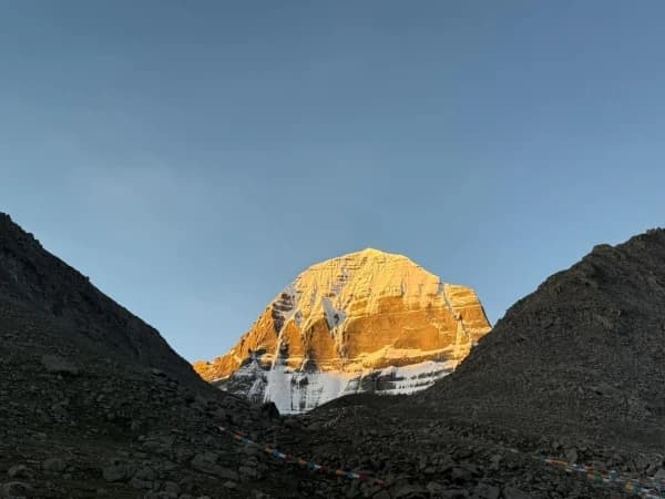
- 3-day kora around Mount Kailash (52km, max altitude Dolma La 5,630m). Emergency oxygen carried.
- Chinese group-visa application handled. Solo travel is not legal on this route; minimum 5 pilgrims per visa group.
- Quote on request. Pricing varies by group size, season, and Chinese permit costs; we confirm within 24 hours.
- Every booking helps fund our Nagarjun Learning Center work at Saldum, where 70 children are taught by one dedicated teacher.
Why I built this trek the way I did
I am Shreejan, the founder of The Everest Holiday. The Simikot trek is the traditional Indian pilgrim route to Kailash. People have walked this way for centuries because the Kerung overland road did not exist. The 20-day shape is what the trek actually requires: 3 days on the Humla Karnali river trail from Simikot to Hilsa, the Nara La pass (4,580m) into Tibet, then the standard Tibetan plateau route to Manasarovar and the 3-day kora.
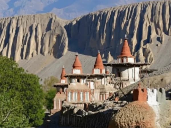
This is the version for pilgrims who want the authentic walking pilgrimage, not the version for people in a hurry. The far-west Nepal region between Simikot and Hilsa is one of the least-visited trekking areas in the country. Foot trails connect every village, there are no roads, and the cultural experience is much closer to medieval Tibet than to modern tourist Nepal.
This is a serious trek. You walk between 5 and 8 hours daily for the first week before you even reach the Chinese border. We do not recommend it for first-time altitude trekkers or pilgrims over 65 unless you have prior high-altitude trekking experience. The fitness requirement is real.
This package is currently priced on request because the supplier-side pricing for permits, ground costs, and the small-aircraft flights to Simikot vary year to year. We send you a fully itemised quote within 24 hours of your inquiry.
Every booking on this trip helps us pay the teacher’s salary at our Nagarjun Learning Center in Saldum, where 70 children get free education. The salary is currently funded out of my own pocket. Your trek is what makes that sustainable.
“I chose the Simikot route over Kerung because I wanted the full pilgrimage experience and was not disappointed. The trek through western Nepal is rarely visited by tourists.”
— Deepak Joshi · Verified Google Review, June 2025 · ★★★★★
The twin-engine plane drops through a gap in the mountains, and suddenly the Simikot airstrip appears below,a narrow shelf carved into the hillside above the Humla Karnali river gorge. You step onto the tarmac and the air hits differently up here: dry, thin, and scented with juniper. This is Nepal's far west, a region most trekkers never see. Foot trails, not roads, connect the villages ahead. The people speak languages that don't appear in any guidebook. And the trail you're about to walk,through terraced barley fields, across swaying suspension bridges, and over the Nara La Pass into Tibet,is the same route that salt traders and pilgrims have used for centuries. Mount Kailash is still days away, but the pilgrimage has already begun.
This 20-day route is the adventurer's path to Kailash Mansarovar. While the standard overland tour drives from Kathmandu to the Kerung border, this route flies you to Simikot in the remote Humla district and treks through some of Nepal's wildest country before crossing into Tibet at Hilsa. You'll walk for days through landscapes that feel untouched by the modern world, cross into Tibet on foot, and then complete the same sacred 52 km Kora around Mount Kailash, crossing the Dolma La Pass at 5,636 m. It's longer, harder, and more rewarding. If the standard route is the pilgrimage, this is the pilgrimage and the adventure combined.
What Makes This Pilgrimage Worth Making
- Trek through Nepal's remote Humla district, one of the least-visited regions in the entire country, where ancient villages, juniper forests, and the Humla Karnali river gorge create a landscape that feels like stepping back in time.
- Cross the Nara La Pass on foot and watch the landscape transform from Nepal's green slopes to Tibet's vast, windswept plateau. This is one of the most dramatic border crossings in the Himalayas.
- Complete the sacred 3-day Kora around Mount Kailash, 52 km on foot, crossing the Dolma La Pass at 5,636 m, sacred to Hindus, Buddhists, Jains, and Bon followers alike.
- Stand on the shores of Lake Mansarovar (4,590 m), one of the highest freshwater lakes on earth. Perform rituals, take a holy dip, or meditate in the silence of the Tibetan Plateau.
- All permits handled by us: China Group Visa, Tibet Travel Permit, Alien Travel Permit, Military Permit, and the special Humla restricted-area permit. We coordinate everything so you don't have to.
- Camp alongside the trail in Nepal's Humla region with our full camping crew, cook, kitchen staff, mules for luggage, and all camping equipment provided. Your meals are prepared fresh on the trail.
- Experience the Saga Dawa Festival if your dates align, the most sacred Buddhist festival of the year, celebrated at the foot of Mount Kailash with the raising of the great prayer flag at Tarboche.
- This is the shortest physical distance to Mount Kailash from Nepal, and the most culturally deep. You'll pass through villages that still trade with Tibet as they have for generations.
- Horse and porter support available during the Kora for pilgrims who need assistance. Emergency oxygen supplied in Tibet.
20-Day Kailash Trek via Simikot Overview
This route has been open since 1993 and remains the most adventurous way to reach Mount Kailash. It begins with a flight from Kathmandu to Nepalgunj, an overnight stay, and then a small-plane flight to Simikot, a spectacularly scenic journey over the western Himalayan foothills. From Simikot, you trek for several days through the Humla Karnali river valley, passing through villages where Tibetan Buddhist culture blends with Hindu traditions and where the daily rhythm of life hasn't changed for centuries.
The trek crosses into Tibet at Hilsa, a small border settlement on the banks of the Karnali. From there, you'll drive across the Tibetan Plateau to Lake Mansarovar and Darchen, where the Kora begins. The three-day walk around Mount Kailash is the spiritual heart of the journey, through the Lha Chu valley with Kailash towering above, over the Dolma La Pass at 5,636 m, and back to Darchen through the eastern valley. After the Kora, the route returns via the Kerung border crossing to Kathmandu.
If you're concerned about altitude, this route actually provides excellent natural acclimatisation. The trekking days in Nepal's Humla region gradually increase your altitude before you ever reach the Tibetan Plateau. Our guides monitor your health daily with pulse oximetres and carry altitude-sickness medication.
Before You Arrive
We recommend arriving in Kathmandu by 4:00 pm the day before departure. This gives you time for a final gear check, trip briefing with your guide, and to ensure everything is ready.
Your Online Briefing
After you book, we'll send you an email with available times for a video call. We'll go through the itinerary day by day, discuss fitness requirements, packing lists, dietary needs, and answer every question. The Simikot route has specific logistics (internal flights, camping gear, border crossing procedures) that we'll explain clearly so there are no surprises.
Simikot Flight Information
There are no direct flights from Kathmandu to Simikot. You'll fly Kathmandu to Nepalgunj (about one hour), stay overnight, and then take a small Dornier or Twin Otter aircraft to Simikot (40-50 minutes) early the next morning. These flights are weather-dependent and delays can occur. We build buffer days into the itinerary for exactly this reason, and The Everest Holiday handles all flight bookings and transfers.
China Group Visa and Permits, We Handle Everything
Travelling to Tibet requires a China Group Visa, Tibet Travel Permit, Alien Travel Permit, and Military Permit. The Humla trekking section also requires a special restricted-area permit. We handle all of this. You send us your passport details in advance, we coordinate with the Chinese Embassy in Kathmandu and our partner agency in Tibet, and everything is ready before you reach the border.
Compare Our Packages
| Standard | Luxury | |
|---|---|---|
| Price from | USD 4,299 | USD 5,499 |
| Meals | All meals included throughout | All meals included (premium quality) |
| Kathmandu Hotel | 3-star hotel (BB basis) | 4-star hotel (BB basis) |
| Nepal Camping | Full camping with cook and crew | Full camping with cook and crew (luxury equipment) |
| Tibet Hotels | Best available guesthouse/hotel | Best available hotel |
| Transport (Tibet) | Van/minibus | Van/minibus |
| Internal Flights | All flights included (KTM-Nepalgunj-Simikot) | All flights included (KTM-Nepalgunj-Simikot) |
| Kora Support | Porters for luggage, emergency oxygen | Porters for luggage, emergency oxygen |
| Permits Included | Chinese visa, all Tibet and Humla permits | Chinese visa, all Tibet and Humla permits |
| Best for | Adventurous pilgrims seeking the full experience | Maximum comfort on the adventurous route |
Two comfort levels, one extraordinary adventure, the route that combines serious trekking with sacred pilgrimage.
Your Pilgrimage, Our Family
When Hari Lal Simkhada helped international travellers experience the Himalayas in the 1960s, he could not have imagined his grandson would still be doing the same thing six decades later. His son, Ganesh Prasad Simkhada, went on to hold senior positions in Nepal's tourism and mountaineering institutions. Today, Shreejan Simkhada carries that legacy forward as CEO of The Everest Holiday, personally designing every itinerary and coordinating the complex logistics that the Simikot route demands.
For this trek, you'll have a Nepali team leader fluent in English and Hindi who stays with you from Kathmandu through the Kora, plus a local Tibetan guide and a full camping crew in the Humla region. Shreejan briefs every team personally before departure.
Need anything? WhatsApp Shreejan directly: +977 9810351300.
Why Travellers Trust Us
- 300+ Reviews Across TripAdvisor, Google, and Trustpilot, 4.9 out of 5 stars, TripAdvisor Travellers Choice 2024
- TAAN Certified, Member #1586, Government Reg: 147653/072/073
- Secure 10% Deposit, pay just USD 430 to reserve your Standard tour, via Himalayan Bank
- All Permits Handled, China Group Visa, Tibet Travel Permit, Alien Travel Permit, Military Permit, and Humla restricted-area permit all arranged by us
- Three Generations, three generations of family guides in the Himalayas
- Simikot Route Specialists, we've operated this exact route multiple times and know every village, every border official, and every contingency plan
Solo Travellers Welcome
Many of our Kailash pilgrims travel alone, and the Simikot route creates an especially strong sense of camaraderie. Days of trekking together through remote country, sharing camp meals under Himalayan stars, and completing the Kora side by side forge friendships that last. Group size ranges from 1 to 20 pilgrims.
If you're a solo traveller, we'll match you to the next available group departure. The shared adventure of the Simikot route means you'll never feel like an outsider, these groups become families.
Difficulty: Strenuous (5 out of 5)
This is the most demanding of our three Kailash routes. You'll trek for several days at altitude in Nepal's Humla region before even reaching Tibet, then complete the 52 km Kora with the Dolma La Pass at 5,636 m. Total trekking days are significantly more than the overland route, and the terrain in Humla is rugged, river crossings, steep ascents, and high passes. You need good cardiovascular fitness and experience walking 6-8 hours a day over uneven ground. That said, our camping crew handles all the logistics, mules carry your main luggage, and our guides are with you every step. We recommend a minimum of eight weeks of altitude preparation and hill walking before departure. If you're unsure whether this route is right for you, talk to Shreejan, he'll give you an honest assessment and may suggest the 15-day overland route as an alternative if needed.
Trek With a Purpose, Changing Lives, One Pilgrimage at a Time
In 2019, Shreejan Simkhada and Shamjhana Basukala founded the Nagarjun Learning Center to give back to the communities that shaped their family. Today, 70 children receive free education and hot meals daily at the flagship centre in Saldum Village, Dhading District. The centre has expanded to 7 locations across Nepal, provided free medical care to over 600 people, and brought internet access to 65 children for the first time in their village's history.
A portion of every booking with The Everest Holiday supports the Nagarjun Learning Center, which is verified and listed on the UN Partner Portal. When you walk the trail to Kailash, your journey helps change a life.