
Last updated 16 September 2026.
Most people pass through Samar without stopping. It is a small place between Chele and Syangboche, a few hours of hard walking north of Kagbeni, and on a fast itinerary it is a lunch stop and nothing more.
I think that is a mistake, and not for sentimental reasons. Samar is the closest village to the cave at Chungsi, which is one of the few places in Upper Mustang whose sacred character is recorded in the Nepali government's own monument inventory rather than only in the things trekking companies tell each other. If you are walking to Lo Manthang, Samar is where you turn aside for it.
Samar at a glance
- Altitude: about 3,620 metres. You will see 3,610 and 3,660 quoted in different places, including in our own itineraries; the village sits around 3,617 m and the gompa above it around 3,651 m, which is where the spread comes from.
- Where: ward 3 of Varagung Muktichhetra Rural Municipality, Mustang, on the classic walking route between Chele and Syangboche.
- Region: Upper Mustang, inside the restricted area, so a permit and a licensed guide are required.
- Why stop: the Chungsi cave, the village gompa, and a sheltered valley after two very exposed passes.
- On our trips: a night on the Upper Mustang Trek and on the Upper Mustang Motorbike Tour.
One honest gap before we go further. There is no reliable population figure for Samar. The census counts you can find online are for the old Chhusang VDC or the present ward, both of which cover a great deal of empty country. Some pages state a house count for Samar, but I cannot source it, so I am not going to repeat it.
Where Samar is, and how you reach it
Coming from the south you start at Kagbeni, which is where the restricted area begins and where your permit is checked. The trail climbs to Chhusang at about 2,950 metres, where the Narshing river meets the Kali Gandaki and the cliffs are stacked with old cave dwellings, then crosses to Chele at roughly 3,070 metres.
From Chele the day to Samar is the one people remember. You climb to the Dajori La at about 3,605 metres, drop, climb again to the Bhena La at about 3,875 metres, and the trail runs high and exposed with very little shade. Samar arrives as a genuine relief: a sheltered pocket of poplar and willow in an otherwise bare landscape. Our own guides describe it as a poplar-lined valley, and that is exactly what it feels like after the passes.
Going the other way, north to south, you come over the Yamda La at about 4,005 metres from the Syangboche side and drop into the village. On our ten-day trek that is day eight, arriving from Ghami over the Nyi La, and it is a long one at roughly 21 kilometres.
What the days into and out of Samar actually involve
Rather than describe this vaguely, here are the real figures from our own itineraries, which is what we plan and price against.
On the ten-day walking trek, the day that arrives in Samar is day eight, Ghami to Samar: about 21 kilometres, seven to eight hours. It opens with the climb out of Ghami over the Nyi La at around 4,010 metres, which is the highest point of the return leg, passes Syangboche, then crosses the Yamda La at about 4,000 metres before dropping to the village. The following morning, day nine, Samar to Kagbeni: about 21 kilometres, six to seven hours, and you lose a lot of height, finishing at 2,804 metres.
Two long days back to back at this altitude is the honest shape of it. They are walkable by anyone reasonably fit, but they are not short, and the wind decides how pleasant they feel.
If you are riding instead, our motorbike itinerary reaches Samar on day four, about 90 kilometres up from Kalopani, and leaves on day five, about 75 kilometres on to Lo Manthang. The riding distances look small on paper. The surface is why they are not.
The cave at Chungsi, and why it is worth the detour
About 2.7 kilometres north-east of Samar, in a deep canyon, is the cave that gives the village its real significance. You will see it written as Chungsi, Chhungsi, Rangchung, Ranchung and Runchung, which is one reason it confuses people.
Local tradition holds that Guru Rinpoche, Padmasambhava, meditated here in the eighth century. That tradition is not something I can prove to you from a scholarly source, and I will not pretend otherwise. What I can tell you is more interesting than a trekking-blog claim: the cave is on Nepal's official list of monuments in Mustang, and the name recorded there is Chhungsi rangjang cave.
That word matters. Rangjang, more often written rangjung, means self-arisen: formed of itself rather than made by hands. So the belief that the cave and its formations were not carved but appeared is not a story a guide invented for visitors. It is embedded in the name the government itself uses for the monument.
There are two chambers. One holds a stupa, and the other a small spring. Accounts of what else is inside vary a great deal from source to source, and rather than pick the most impressive version I will simply tell you to go and look. The approach runs down into a canyon with steep walls and a footbridge, and it is the walk as much as the cave that stays with you.
On altitude, be sceptical of precision. You will read 3,700 metres on some pages and around 3,500 on others; the terrain models put the cave mouth near 3,570 to 3,590 metres. Call it around 3,600 metres and accept that nobody has surveyed it properly.
The village itself
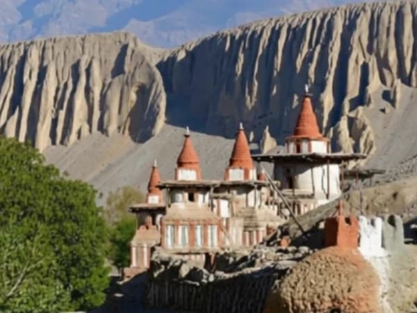
Samar has its own gompa, Orgyen Drub Guye. The name is worth pausing on, because Orgyen is one of the standard epithets of Padmasambhava. The village's association with him is therefore not only about the cave up the valley; it is carried in the name of the monastery in the village.
There is also a chorten recorded in the official inventory as Samar Chhorten. Beyond that, Samar is what it looks like: a small cluster of flat-roofed houses, stacked firewood on the walls, barley ground where the land allows it, and trees, which at this altitude in this district is genuinely unusual.
You will find pages claiming millet is farmed here. Millet does not grow at 3,600 metres, and that line has been copied from site to site. Ask your guide what is actually in the fields when you pass; the answer depends on the season and the year.
Where you sleep, honestly
Samar has a handful of small lodges, and they are basic teahouses. A bed, a shared dining room with a stove, simple food, intermittent power.
I am saying this plainly because itineraries across this industry, ours included, tend to write "hotel" for every night on a trip, and that word sets an expectation Samar cannot meet. There is no hotel here. There are teahouses, they are clean enough, and the people who run them are kind. If you want hotel standard in Upper Mustang you will find it in Jomsom or Lo Manthang, not in Samar.
Permits and rules, 2027
Samar is inside the Upper Mustang restricted area. That means:
- A restricted-area permit at US$50 per person per day, arranged through a registered agency
- An Annapurna Conservation Area permit on top
- A licensed guide, which is mandatory, not advisory
- A maximum of seven trekkers per guide on a single permit
Since March 2026 solo trekkers can obtain a restricted-area permit, which was not previously possible, but the agency and the licensed guide are still required. The full picture is in our Upper Mustang cost and permit guide, and these rates hold for 2027 departures.
When should you come?
Upper Mustang sits in the rain shadow behind the Annapurnas, so it is one of the few parts of Nepal that is walkable through the monsoon. The dust and the afternoon wind are the real constraints here, not rain. Spring and autumn are the most comfortable, and winter is hard: cold, and many families move down the valley for the season.
If your interest is the Tiji festival at Lo Manthang, note that it falls on 1 to 3 June in 2027 and that lodges along this route are spoken for a year ahead.
Common questions
Can I visit Chungsi cave without staying in Samar? Yes, it can be done as a detour on the walk between Chele and Syangboche, but you will want the time. Tell your guide before the day starts, not at the junction.
How hard is the day into Samar? Two passes from the Chele side, both climbs of several hundred metres, on exposed ground. It is not technical. It is simply long, dry and high, and the wind gets up after midday, which is why we start early.
Is there mobile signal? Patchy, and do not plan around it.
Can I ride rather than walk? Yes. Samar is a night on our motorbike tour, and the Mustang road corridor reaches a good deal of this route now. What you gain in reach you lose in the slow arrival on foot over the passes.
Is the cave suitable for anyone? The descent into the canyon is steep. If you are unsure on steep loose ground, say so, and your guide will judge it with you on the day.
Nearby on the same route
North of Samar the trail runs to Syangboche and on to Dhakmar, with its red cliffs, then to Ghar Gompa at Lo Gekar, the oldest monastery on the plateau and another place tied to Guru Rinpoche. Beyond that lie Tsarang with its dzong and its long prayer wall, and finally Lo Manthang itself. South, the road runs back through Kagbeni to Jomsom.
If you want to walk this route, our ten-day Upper Mustang Trek takes in Samar in both directions. Upper Mustang is the trip I make myself when I can, so if you want to talk it through rather than read about it, message me on WhatsApp or write to [email protected].
Written by Shreejan Simkhada, CEO of The Everest Holiday and third-generation Himalayan guide. TAAN Member #1586.
 Chat with Shreejan