Nepal Travel Guide & Expert Trekking Tips
Everest Base Camp Trek Map 2027: Route, Stops and Heights Day by Day


Updated 2 November 2026.
Short answer: The Everest Base Camp route runs north from Lukla (2,860 m) up the Dudh Koshi and Khumbu valleys, through Namche Bazaar (3,440 m), Tengboche, Dingboche and Lobuche to Gorak Shep and Base Camp (5,364 m). It is about 130 km there and back, and you walk the same valley both ways. Our 12-day trek costs from USD 1,399 Budget, USD 2,785 Standard and USD 4,999 Luxury per person for two to four people. Our route map is below.
I am Shreejan, and I run The Everest Holiday with my family. This is the map we use for our own 12-day Everest Base Camp trek. It shows where you sleep each night, and I have added the things a map leaves out.
Everest Base Camp trek route map

Tap the map to open the full-size picture. You can also open the same route on Google Maps and zoom in on any village.
Three things to know when you read it.
The orange line is the way up and the dashed green line is the way down. They run so close because it is the same valley. The lines join the stops and are not a GPS track.
The map marks Pheriche on the way down. Our current itinerary sleeps at Pangboche on day 9, a little lower, where the Pheriche and Dingboche valleys have joined. Go by the table below.
Some height labels differ slightly from the table. Dingboche says 4,360 m on the map and 4,410 m in our itinerary, because published heights vary by source. Use the table.
Every stop on the map, day by day
| Day | Route | Height reached |
|---|---|---|
| 1 | Fly to Lukla (2,860 m), walk to Phakding | 2,610 m |
| 2 | Phakding to Namche Bazaar | 3,440 m |
| 3 | Rest and acclimatisation day at Namche | 3,440 m |
| 4 | Namche to Tengboche | 3,860 m |
| 5 | Tengboche to Dingboche | 4,410 m |
| 6 | Rest and acclimatisation day at Dingboche | 4,410 m |
| 7 | Dingboche to Lobuche | 4,940 m |
| 8 | Lobuche to Everest Base Camp, then Gorak Shep | 5,364 m |
| 9 | Kala Patthar at sunrise, then down to Pangboche | 5,545 m |
| 10 | Pangboche to Namche Bazaar | 3,440 m |
| 11 | Namche to Lukla | 2,860 m |
| 12 | Fly Lukla to Kathmandu | 1,350 m |
You walk 5 to 8 hours on most days. The Everest Base Camp itinerary, day by day has hours and kilometres, and the distance guide breaks down the 130 km.
Everest Base Camp altitude profile
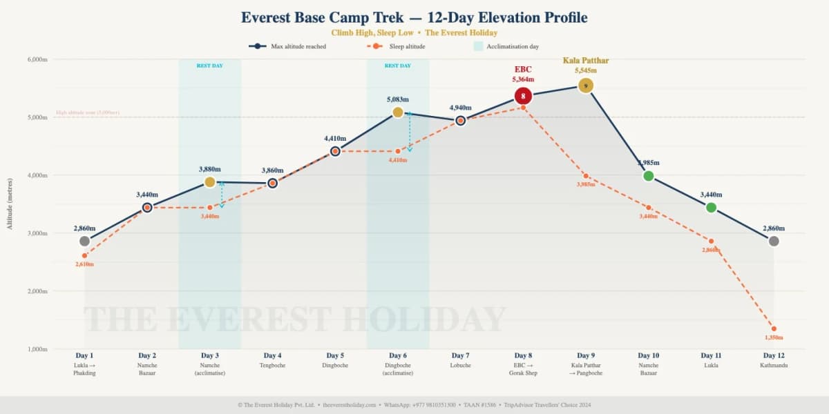
Look at days 3 and 6. The line goes flat. Those two rest days at Namche and Dingboche are the most useful days on the trek, because they give your body time before Lobuche. My piece on where people struggle on the altitude profile goes further.
Notice too that the highest point is not Base Camp. It is Kala Patthar at 5,545 m, the hill above Gorak Shep. Base Camp has no view of the top of Everest, and Kala Patthar does.
What the map does not show
The start point can change. In the busy seasons, roughly 15 March to 15 May and 25 September to 30 November, flights to Lukla leave from Manthali (Ramechhap) instead of Kathmandu. It is about 40 minutes by air from Kathmandu and about 20 from Manthali. If you land back at Manthali, we drive you to Kathmandu, which takes 4 to 6 hours, and that transport is included. My guide to Ramechhap and the Lukla flight explains it.
There are no roads on this route at all. Everything above Lukla moves on foot, on yaks or by helicopter, and that is why a meal costs more the higher you go.
The trail is not one line. Above Pangboche it splits. One branch climbs to Dingboche and the other to Pheriche, and they meet again below Lobuche. We go up by Dingboche because of the rest day there.
Best time to walk this route
| Months | What it is like | My view |
|---|---|---|
| October to November | Clearest and busiest. Late October can carry a cyclone-tail risk, so we watch the forecast. | Best overall |
| March to May | The second main season, warmer than autumn. | Very good |
| December to February | Cold and quiet. | For people who are ready for it |
| June to September | Monsoon cloud, and Lukla flights are less reliable. | Not my choice |
The full month-by-month picture is in the best time to trek to Everest Base Camp.
What this route costs
| Group size | Budget | Standard | Luxury |
|---|---|---|---|
| 1 person | USD 2,275 | USD 3,345 | USD 5,640 |
| 2 to 4 people | USD 1,399 | USD 2,785 | USD 4,999 |
Prices are per person, read from the live trek page on 2 November 2026. Larger groups pay less, and the full table is on the trek page. Your three permits are included, NPR 8,000 in all. Kathmandu hotels are quoted separately. The Everest Base Camp trek cost guide has every other line of the budget.
Everest Base Camp map questions
How far is it from Lukla to Everest Base Camp?
About 65 km each way, so about 130 km there and back. Most walking days are 10 to 14 km. Altitude makes those days feel longer than the number suggests.
Where does the Everest Base Camp trek start?
At Lukla (2,860 m), after a flight from Kathmandu or Manthali. If you would like to avoid the flight, we also run a 15-day trek by road.
What is the highest point on the route?
Kala Patthar at 5,545 m. Base Camp itself is 5,364 m. The highest place you sleep is Gorak Shep at about 5,164 m. Your insurance needs to cover helicopter rescue up to 6,000 m.
Is the route the same up and down?
Mostly yes. You come back through Pangboche, Namche and Lukla, and it takes three days to come down what took eight days to climb.
Which permits apply along this route?
Three: Sagarmatha National Park at NPR 3,000, the Khumbu Pasang Lhamu Rural Municipality fee at NPR 3,000 and a TIMS card at NPR 2,000. My Everest Base Camp permit guide covers where each one is checked. We arrange them all.
Can I get lost on the Everest Base Camp trail?
On a clear day the main trail is easy to follow. Cloud and snow above Lobuche are a different matter. You will not need to think about it with us, because a licensed guide walks with you on every tier.
Do I need a paper map or GPS app?
Not to find the way with us. An offline app is still a nice thing to have if you enjoy seeing where you are, and Namche is a good place to look at it with your guide on the rest day.
If you want to go through the route with me for your own dates, message me on WhatsApp at +977 9810351300.
Planning a trip to Nepal?
Drop us your details and tell us what you have in mind. We will put together a personalised plan and get back to you.
Take our free 2-minute quiz and get personalised recommendations based on your fitness, experience, and travel style.
Find your trekMore from the travel blog
All stories and guides Nepal Travel Guide & Expert Trekking TipsAnnapurna Circuit Trek Map 2027: Route, Stops, Heights and Road SectionsOur route map of the 12-day Annapurna Circuit, every stop and height day by day, the altitude chart, where the road runs and what the map leaves out.
 Nepal Travel Guide & Expert Trekking TipsAnnapurna Base Camp Trek Cost From India in 2027: Fares, Permits and a Rupee BudgetWhat the Annapurna Base Camp trek costs for an Indian trekker in 2027: our USD prices with a labelled rupee conversion, no visa, ID rules, SAARC permit fees, and the Kathmandu and Sunauli routes.
- Nepal Travel Guide & Expert Trekking TipsAnnapurna Base Camp Trek Cost From the USA in 2027: Flights, Time Off and Total BudgetWhat the 9-day Annapurna Base Camp trek costs for an American in 2027: package prices, flight routings from New York, Chicago and the West Coast, the visa, insurance to 4,500 m and how many days of leave you need.