
Nepal Travel Guide & Expert Trekking Tips
Annapurna Circuit Trek Map 2027: Route, Stops, Heights and Road Sections

Updated 2 November 2026.
Short answer: The Annapurna Circuit is a horseshoe around the Annapurna massif. On our 12-day route you drive from Kathmandu to Bhulbhule (845 m), walk north and west up the Marsyangdi valley to Manang (3,540 m), cross Thorong La (5,416 m), come down to Muktinath (3,800 m), then drive through Jomsom to Pokhara. The trek costs from USD 995 Budget, USD 1,575 Standard and USD 2,690 Luxury per person for two to four people. Our route map is below.
I am Shreejan, and I run The Everest Holiday with my family. People ask me for a map of this trek for one reason: they want to know where the walking stops and the road starts. This page is the map we use for our own 12-day Annapurna Circuit trek, with notes on what a map cannot tell you.
Annapurna Circuit trek route map

Tap the map to open the full-size picture. You can also open the same route on Google Maps and zoom in on any village.
Three things to know when you read it.
The lines join the stops. They are not a GPS track, so do not navigate from this picture. The long dashed line from Jomsom to Pokhara looks as if it crosses Annapurna I. It does not. The road runs down the Kali Gandaki valley through Beni, around the mountain.
The orange line at the bottom runs to Kathmandu, which is off the edge of the picture.
Some height labels differ a little from the table below. Chame says 2,610 m on the map and 2,670 m in our itinerary, because published heights vary by source. Use the table.
Every stop on the map, day by day
| Day | Route | Sleep at | Height | How |
|---|---|---|---|---|
| 1 | Kathmandu to Bhulbhule | Bhulbhule | 845 m | Drive, 7 to 8 hours |
| 2 | Bhulbhule to Jagat | Jagat | 1,300 m | Walk |
| 3 | Jagat to Dharapani | Dharapani | 1,860 m | Walk |
| 4 | Dharapani to Chame | Chame | 2,670 m | Walk |
| 5 | Chame to Upper Pisang | Upper Pisang | 3,300 m | Walk |
| 6 | Upper Pisang to Manang | Manang | 3,540 m | Walk |
| 7 | Rest day at Manang | Manang | 3,540 m | Acclimatisation |
| 8 | Manang to Ledar | Ledar | 4,250 m | Walk |
| 9 | Ledar to Thorong High Camp | High Camp | 4,900 m | Walk |
| 10 | Over Thorong La (5,416 m) to Muktinath | Muktinath | 3,800 m | Walk, usually 7 to 10 hours |
| 11 | Muktinath through Jomsom to Pokhara | Pokhara | 820 m | Drive, about 8 to 10 hours |
| 12 | Pokhara to Kathmandu | Kathmandu | 1,400 m | Drive |
Most walking days are 6 to 7 hours. For what each day is like on the ground, read my Annapurna Circuit day-by-day guide.
Annapurna Circuit altitude profile
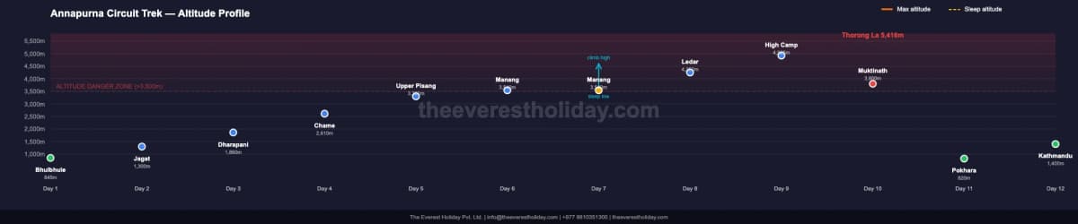
This chart matters more than the map. You gain 4,571 m between Bhulbhule and the pass, and you do it slowly. The rest day at Manang and the short climbs to Ledar and High Camp are the reason.
The trek also runs anticlockwise on purpose. Going this way, the climb to the pass is spread over nine days. From Muktinath the same pass would mean climbing about 1,600 m in a single push, which is why very few people cross it in that direction.
Where the road is on the Annapurna Circuit
This is what no map shows well. A road now runs along much of the Marsyangdi side, which is why we start walking at Bhulbhule and do not wander along it for days. By Chame on day 4, the mountains arrive.
The road also gives you a way out. If someone is unwell below Manang, a vehicle can usually reach them. Above Manang, that changes. There is no road over Thorong La, and a helicopter cannot reach the pass itself, so any rescue happens from lower ground. That is why we ask for insurance to 5,500 m with helicopter evacuation.
As of 14 October 2026 the Besisahar to Chame road and the Beni to Jomsom road are repaired and open to vehicles. We check again 48 hours before you leave. My guide to the road on the Annapurna Circuit has more detail.
Best time to walk this route
| Months | What it is like | My view |
|---|---|---|
| October to November | Clearest and most stable. Thorong La is normally open. | Best overall |
| March to April | Warm, rhododendron lower down, a little more haze. | Second best |
| December to February | Very cold. Thorong La can be snowed shut. | Only with a flexible plan |
| June to mid-September | Wet and leech-prone low down, though the Manang side is drier. | Avoid |
What this route costs
| Group size | Budget | Standard | Luxury |
|---|---|---|---|
| 1 person | USD 1,450 | USD 2,075 | USD 4,350 |
| 2 to 4 people | USD 995 | USD 1,575 | USD 2,690 |
Prices are per person, read from the live trek page on 2 November 2026. Larger groups pay less, and the full table is on the trek page. Permits are included: ACAP at NPR 3,000 and a TIMS card at NPR 2,000. Kathmandu hotels are quoted separately. The Annapurna Circuit cost guide covers everything else.
Annapurna Circuit map questions
How long is the Annapurna Circuit in kilometres?
Usually around 160 to 230 km, depending on your start, your finish and any side trips. New roads have shortened the part most people walk. Days walked matter more than the total here, because altitude decides how you feel.
Where does the Annapurna Circuit start and end?
Ours starts with a drive from Kathmandu to Bhulbhule and finishes at Muktinath on foot. You then drive to Pokhara and on to Kathmandu. No flights are needed.
What is the highest point on the map?
Thorong La at 5,416 m, crossed on day 10. The highest place you sleep is Thorong High Camp at about 4,900 m, and the lodging there is basic.
Can I fly out of Jomsom instead of driving?
Not on a normal scheduled flight at the moment. Scheduled Pokhara to Jomsom flights stopped in October 2026 for about five months, though charters still run. That is why our route drives out through the Kali Gandaki.
Does the route go to Tilicho Lake?
Not on the 12-day version. Tilicho sits west of Manang and is a side trip of several days. Our 16-day trek with Tilicho Lake includes it, and my guide to 12, 14 or 16 days helps you choose.
Do I need a paper map or GPS app?
Not to find the way with us, because a licensed guide walks with you on every tier. An offline app on your phone is still a nice thing to have if you enjoy seeing where you are.
Can I walk the Annapurna Circuit without a guide?
The Nepal Tourism Board lists the Annapurna Circuit among routes that need a licensed guide and an agency-issued TIMS card. We always walk with one, and the guide is in the price.
Where is the hardest part on the map?
The short stretch from High Camp over Thorong La to Muktinath. It is the longest day of the trek, and you go up about 500 m and down about 1,600 m at the highest altitude of the whole route. My Thorong La guide explains how we time it.
If you want to go through the route with me for your own dates, message me on WhatsApp at +977 9810351300.
Planning a trip to Nepal?
Drop us your details and tell us what you have in mind. We will put together a personalised plan and get back to you.
Take our free 2-minute quiz and get personalised recommendations based on your fitness, experience, and travel style.
Find your trekMore from the travel blog
All stories and guides Nepal Travel Guide & Expert Trekking TipsAnnapurna Base Camp Trek Cost From India in 2027: Fares, Permits and a Rupee BudgetWhat the Annapurna Base Camp trek costs for an Indian trekker in 2027: our USD prices with a labelled rupee conversion, no visa, ID rules, SAARC permit fees, and the Kathmandu and Sunauli routes.
- Nepal Travel Guide & Expert Trekking TipsAnnapurna Base Camp Trek Cost From the USA in 2027: Flights, Time Off and Total BudgetWhat the 9-day Annapurna Base Camp trek costs for an American in 2027: package prices, flight routings from New York, Chicago and the West Coast, the visa, insurance to 4,500 m and how many days of leave you need.
- Nepal Travel Guide & Expert Trekking TipsAnnapurna Base Camp Trek Cost From Australia: The All-In Numbers for 2027What the Annapurna Base Camp trek costs an Australian in 2027: package tiers with approximate AUD, flights from Sydney, Melbourne, Brisbane and Perth, the visa, Pokhara transfers and insurance to 4,500 m.