
Bhairahawa (Siddharthanagar): The Airport Town for Lumbini, and What to Expect

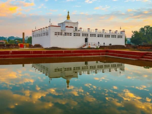
Last updated 17 October 2026.
Short answer: Bhairahawa, officially Siddharthanagar, is the town in Nepal's southern plains where you land for Lumbini. Gautam Buddha International Airport is here, about 30 minutes by air from Kathmandu, and Lumbini is about 25 km to the west by road. Most visitors only pass through, from the airport straight to Lumbini. That is how our Lumbini Tour, 4 days by flight works, from USD 780 on Budget, USD 1,060 on Standard and USD 1,375 on Luxury per person for two to four people.
I am Shreejan. People often book a flight to "Lumbini" and are surprised to land somewhere called Bhairahawa. This is a short guide to the town, so you know where you are and what happens between the airport and the Buddha's birthplace.
Where is Bhairahawa?
Bhairahawa is in Rupandehi District, in Lumbini Province, on the flat Terai plains along Nepal's southern border. Its official name is Siddharthanagar, but almost everyone, including the airlines, still calls it Bhairahawa. The town sits right on the border with India, next to Sonauli in Uttar Pradesh, so it is busy with trade, buses and border traffic. The Sacred Garden at Lumbini is about 25 km west.
Bhairahawa at a glance
| Fact | Bhairahawa (Siddharthanagar) |
|---|---|
| Official name | Siddharthanagar |
| District and province | Rupandehi, Lumbini Province |
| Population | 74,436 (2021 census) |
| Airport | Gautam Buddha International Airport, 105 m above sea level |
| From Kathmandu | About 30 minutes by air |
| To Lumbini | About 25 km by road |
| Border | Next to Sonauli, India |
| Best months | October to March; April to June is very hot |
How do you get to Bhairahawa from Kathmandu?
By air is the easy way. Domestic flights from Kathmandu take about 30 minutes, and Buddha Air, Shree Airlines and Yeti Airlines fly the route. The airport became an international airport, with its first international flight in May 2022, but for our guests it is almost always the domestic flight from Kathmandu. My domestic flights guide explains baggage limits and timings.
By road it is a long day from Kathmandu, so on a short trip the flight saves you most of a day each way. On our tours a driver and your guide meet you at the airport and take you straight to Lumbini.
What is Bhairahawa like?
It is a working border town, not a sightseeing town. Expect a busy main road, shops, banks, bus stations and a lot of traffic heading for the border. The landscape around it is flat farmland and rice fields, very different from the hills. Most people spend only the drive between the airport and Lumbini here, and that is what I suggest too: the reason to come is Lumbini.
The heat matters. The Terai is at little more than 100 metres, so from April to June the afternoons are very hot. We plan the Sacred Garden for the late afternoon and the monastery zone for the morning for exactly this reason.
Bhairahawa on our tours
| Tour | How Bhairahawa fits | From, 2 to 4 people |
|---|---|---|
| Lumbini Tour, 4 days | Fly in on day 1, Sacred Garden that afternoon, fly back on day 4 | USD 780 / 1,060 / 1,375 |
| Lumbini and Chitwan Tour, 5 days | Fly in on day 1, then drive east to Chitwan on day 3 | USD 1,030 / 1,335 / 1,705 |
| Kathmandu, Lumbini and Chitwan, 7 days | Fly in on day 3 after two days in Kathmandu | USD 1,230 / 1,700 / 2,275 |
Prices are per person for Budget, Standard and Luxury. Read more about the sites themselves in my Lumbini travel guide and my post on Tilaurakot, the walled site where Siddhartha grew up. If you are deciding how many days to give it, my 7-day Kathmandu, Lumbini and Chitwan post walks through a full itinerary.
When is the best time to visit?
| Months | What it is like |
|---|---|
| October and November | Warm days, clear after the monsoon. A very good time. |
| December to February | Comfortable days, but fog in the mornings can delay flights. Bring a warm layer for early starts. |
| March | Warming up, still pleasant. |
| April to June | Very hot afternoons. Go early and late, rest in the middle of the day. |
| July to September | Monsoon. Heavy rain, humid, green fields. |
Frequently asked questions
Is Bhairahawa the same as Lumbini?
No. Bhairahawa is the town with the airport. Lumbini, the Buddha's birthplace, is about 25 km west by road.
What is the airport for Lumbini called?
Gautam Buddha International Airport, in Bhairahawa (Siddharthanagar).
How long is the flight from Kathmandu to Bhairahawa?
About 30 minutes.
Is Siddharthanagar the same as Bhairahawa?
Yes. Siddharthanagar is the official name, and Bhairahawa is the name most people and airlines still use.
Should I stay overnight in Bhairahawa?
Usually not. We take you straight to Lumbini, which is calmer and closer to the sites.
How hot does it get?
Very hot from April to June. October to March is the most comfortable time for Lumbini.
How do you plan this with us?
Message me on WhatsApp on +977 9810351300 with your dates, how many of you there are and how many days you have. I will tell you which of the Lumbini tours I would choose and send you the exact quote.
Written by Shreejan Simkhada, CEO of The Everest Holiday, from a family of three generations of family guides. TAAN Member #1586. WhatsApp +977 9810351300.
Planning a trip to Nepal?
Drop us your details and tell us what you have in mind. We will put together a personalised plan and get back to you.
Take our free 2-minute quiz and get personalised recommendations based on your fitness, experience, and travel style.
Find your trekMore from the travel blog
All stories and guides Nepal Travel Guide & Expert Trekking TipsPoon Hill Trek Map 2027: Route, Stops and Heights Day by DayOur route chart of the 6-day Poon Hill trek, every stop and height day by day, and what a map leaves out.
 Nepal Travel Guide & Expert Trekking TipsEverest Three Passes Trek Map 2027: Route, Stops and Heights Day by DayOur route chart of the 17-day Everest Three Passes trek, every stop and height day by day, and what a map leaves out.
 Nepal Travel Guide & Expert Trekking TipsGokyo Lakes Trek Map 2027: Route, Stops and Heights Day by DayOur route chart of the 10-day Gokyo Lakes trek, every stop and height day by day, and what a map leaves out.