
Thuman: The Tamang Village on Day 4 of the Tamang Heritage Trail and How Our Trek Reaches It

Short answer: Thuman is a Tamang village at about 2,340 m, where our 12-day Tamang Heritage Trail spends its fourth night, after the longest climb of the route and before the walk to Briddim. See our Tamang Heritage Trail.
Thuman is the village where our 12-day Tamang Heritage Trail spends its fourth night, after the longest climb of the route and before the walk to Briddim. Almost nothing written about it online says what a day there is actually like, so this page sets out what our own itinerary says and what outside sources confirm.
Where is Thuman and who lives there?
Thuman is a former village development committee in Rasuwa District, in the north of Nepal's Bagmati region. At the 1991 census it recorded 929 people living in 188 households. That is a very old count, and Nepal has since reorganised its local government, so please treat it as a sense of scale and not a current figure. Our itinerary describes Thuman as a Tibetan-style Tamang village at 2,340 metres.
The Tamang are the main community of this district. At the 2021 census the district had 46,689 people, of whom 68.8 per cent are Tamang, and 67.5 per cent speak Tamang as their first language. There are 1,639,866 Tamang people in Nepal in total, and about 87 per cent of them are Buddhist. So in Thuman you are walking into the middle of Tamang country, not a corner of it.
As of 2013, Thuman, Langtang and Haku were the three village development committees in Rasuwa not touched by any kind of road. I have not checked what has changed since 2013, and our itinerary has you arriving on foot over a ridge, so I plan on that basis.
Which day of the Tamang Heritage Trail do you reach Thuman?
Day 4 of our 12-day Tamang Heritage Trail trek. These are the days around it, copied from our day-by-day plan. Distances and hours are ours, and heights are the ones in our itinerary.
| Day | Route | Distance | Walking | Sleep |
|---|---|---|---|---|
| 2 | Syabrubesi to Gatlang | 12.1 km | 6 hours | 2,240 m |
| 3 | Gatlang to Tatopani | 12.2 km | 6 hours | 2,610 m |
| 4 | Tatopani to Thuman via Nagthali | 9.2 km | 6 hours | 2,340 m (high point 3,170 m) |
| 5 | Thuman to Briddim | 14 km | 5 to 6 hours | 2,230 m |
| 6 | Briddim to Lama Hotel | 13 km | 6 hours | 2,470 m |
Day 1 is the drive from Kathmandu to Syabrubesi, which our itinerary puts at 7 to 9 hours. From day 7 the route joins the Langtang valley, reaches Kyanjin Gompa on day 8, spends day 9 there, and comes back down to Syabrubesi on day 11 before the drive to Kathmandu on day 12.
What is the walk from Tatopani over Nagthali to Thuman like?
It is the day that decides how you feel about the whole trek. You start from the hot-spring settlement of Tatopani at 2,610 metres and, by our itinerary, spend about two hours in forest to a small settlement called Brimdang. Then comes about two more hours of climbing to Nagthali Danda at 3,170 metres, which is the highest point of the first half of the trek. From there the trail descends gently to Thuman at 2,340 metres, with about six hours of walking in all.
The honest trade-off is that you climb about 560 metres from Tatopani to Nagthali and then lose most of it again on the way down. On a clear morning our itinerary says Nagthali gives views of Langtang Lirung, Shishapangma and Ganesh Himal. I cannot promise the sky, and clouds close in more often than the photographs suggest. If the weather is poor, the walk is still a good forest day, but the reason you climbed is hidden, and you should know that before you pay for the trek.
What is there to see in Thuman and Briddim?
Our itinerary says small monasteries stand along the Nagthali route, and that Thuman is a Tibetan-style Tamang village. On day 5 it says you follow the old trade route to Tibet, cross the Bhote Koshi, and reach Briddim, where you stay in a local home. Briddim, a Tamang village, is listed among the district's tourist attractions, and the name is also spelled Briddhim.
That is all I will claim. We have no reliable source for the name or age of any monastery in Thuman, for craft traditions, or for festival dates, so I won't invent one for you to plan around. What I can do is tell you how to behave. Ask your guide which way to walk round each mani wall and chorten, ask before photographing anyone or anything inside a prayer hall, and treat what a villager tells you through our guide as the real source.
From Timure on day 5, our itinerary says the historic Rasuwa Gadhi fort, at the Nepal and Tibet border, can be visited after a three-hour walk. The fort was built in 1855, there was a three-day battle in the area in July 1792, and the crossing was opened for trade in December 2014. That is a long extra walk on top of a 5 to 6 hour day, so ask us before you plan it in.
Can you do the Tamang Heritage Trail after the August 2026 flood?
I am not going to give you a status here, because it would be out of date within days. On 26 August 2026 a flood came down the Bhote Koshi and damaged Timure and Syabrubesi, and day 5 of this route passes through Timure. Our own flood pages are updated as the position changes: Is the Langtang trek affected by the Rasuwa flood?, which treks in Nepal are open after the flood, and Langtang in November and December. Read those first, and message me with your dates before you pay anything.
If you want to see the geography that makes this route different from the Langtang valley, our guides to Gatlang and Syabrubesi cover the villages on either side of Thuman.
What permits do you need for Thuman?
The route is inside Langtang National Park. The Nepal Tourism Board's park fee page lists Langtang at NPR 3,000 per person per entry for foreigners, with children under 10 free. The Tourism Board's TIMS page lists the Tamang Heritage Trek among the routes that need a trekking agency issued TIMS card and a licensed trekking guide under the rule that took effect on 31 March 2023, and puts the TIMS fee at NPR 2,000 for non-SAARC visitors.
Our package includes the Langtang National Park permit, the TIMS card and the Rasuwa restricted-area permit (USD 20 per person for a week, because Thuman is inside the restricted section) in every tier. We always trek with a licensed guide, which on this route is also the rule. If any other local charge applies to your dates, we will tell you before you pay a deposit, not after.
How much does the Tamang Heritage Trail cost?
Our current prices for the 12-day trek, per person, are USD 1,020 Budget, USD 1,725 Standard and USD 2,515 Luxury for two to four people (USD 1,710, 2,290 and 3,885 for a solo traveller), and groups of up to twenty are welcome. Budget does not include meals or a porter, and trekkers carry their own bags. Standard includes all meals and one porter for every two trekkers, so a solo traveller on Standard has the guide carry up to 10 kg instead. Luxury includes all meals with fruit, nuts and soft drinks, and a dedicated porter for each trekker. Kathmandu hotels are not included in any trek tier.
Our deposit is 10 per cent, and the rest is paid in Kathmandu. You can reschedule free of charge with at least 7 days' notice (this route needs a restricted-area permit) to any date within one year. The 10 per cent deposit is not refunded if you cancel, and there is no refund when you cancel, only free rescheduling.
When is the best time to visit Thuman?
Our package names autumn, September to November, as the most popular season, with stable weather, clear views most days, daytime temperatures of 10 to 18 degrees Celsius and nights between minus 3 and 5. Spring, March to May, is described as clear and warm at 10 to 20 degrees, with rhododendrons in bloom. Monsoon is wet and the trails are slippery, and winter is cold, with snow higher up and far fewer trekkers. These are our own seasonal notes, not a measured record for Thuman. Book early for the Dashain weeks if you want the autumn window, as buses and flights are tight: see our Dashain guide.
Is the Thuman section safe, and who is it for?
Our package grades the trek Moderate. Thuman itself is at 2,340 metres, and the high point on the route is Nagthali at 3,170 metres, until you join the Langtang valley and climb to Kyanjin Gompa at 3,870 metres on day 8. The main risks are the length of the days, the steep climbs and descents, and weather, not altitude. Our package says travel insurance is required and must cover emergency helicopter rescue up to 5,000 metres, because the optional Tserko Ri viewpoint is at about 4,984 metres. Buy it before you leave home. Every package includes first aid and an oximeter to check oxygen levels.
Our package says you stay in teahouses and local lodges, and that mobile signal can be patchy. If you want hotel-style comfort every night, this is not that kind of trek, and in Briddim you stay in a local home.
The short version
Thuman is a Tamang village in Rasuwa District at 2,340 metres on our itinerary, reached on day 4 of our 12-day Tamang Heritage Trail after a six-hour walk over Nagthali. Park permit, TIMS and the Rasuwa restricted-area permit are included, and a licensed guide is required and provided; we don't give monastery names or festival dates, because we can't confirm them. If you want to talk through whether this route suits you, or what the flood position is for your dates, message me on WhatsApp on +977 9810351300.
Written by Shreejan Simkhada, CEO of The Everest Holiday, from a family of three generations of guides. TAAN Member #1586.
Planning a trip to Nepal?
Drop us your details and tell us what you have in mind. We will put together a personalised plan and get back to you.
Not sure which Nepal trek is right for you?
Take our free 2-minute quiz and get personalised recommendations based on your fitness, experience, and travel style.
Find Your Perfect Trek →
Best Time to Climb Mera Peak in 2027: Month by Month, Weather and Summit-Day Windows
When to climb Mera Peak in 2027: autumn versus spring, rain at Lukla month by month, the NMA royalty by season, flights via Manthali, insurance height and 2027 prices.
Read More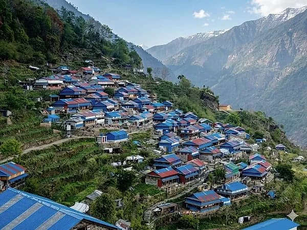
Ruby Valley Trek 2027: The Complete Guide to the 9-Day Route from Syabrubesi to Dhading Besi
The 9-day Ruby Valley trek from Syabrubesi over the Pangsang La to Tipling, Borang and Dhading Besi: day-by-day route, permits, best months and 2027 prices from USD 560.
Read More
Best Time for the Rara Lake Trek: Month by Month for 2027
Rara Lake month by month: measured rain and temperature, where sources disagree on freezing, rhododendron months, October crowds and 2027 prices.
Read More Chat with Shreejan