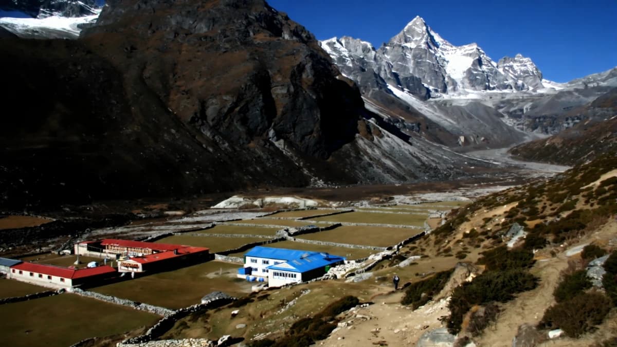
At 4,380 metres, Lungden is the kind of place that exists for one reason only: the pass above it. There is no village. There is no community. There is a teahouse, one teahouse, built from stone and roofed with tin, sitting on a moraine flat in a valley so high and so barren that the concept of "settlement" feels like an exaggeration. Lungden is an overnight stop. A place to eat dal bhat, check your gear, set your alarm for three in the morning, and try to sleep at an altitude where sleep is something your body remembers doing at lower elevations but cannot quite manage here.
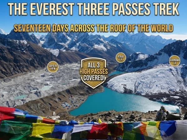
The reason Lungden exists is Renjo La, the 5,360-metre pass that connects the Gokyo Valley to the Thame Valley on the western side of the Khumbu. Renjo La is one of the three high passes on the Everest Three Passes trek, the most demanding standard trekking route in the Khumbu, which crosses Kongma La (5,535 metres), Cho La (5,420 metres), and Renjo La in a seventeen-to-twenty-day circuit that visits both Everest Base Camp and the Gokyo Lakes.
Trekkers who cross Renjo La from east to west sleep at Lungden the night before. They arrive in the afternoon from the Gokyo Lakes, a three-to-four-hour walk south and then west from the turquoise shores of the third lake, and they arrive tired, altitude-affected, and aware that tomorrow's crossing is the last major challenge of the Three Passes route. The teahouse at Lungden provides food, shelter, and the specific pre-pass atmosphere that every high camp on every trekking route shares: a mixture of anticipation, anxiety, and the quiet determination of people who have walked too far to turn back.
The Three Passes Context
The Everest Three Passes trek is the Khumbu's ultimate challenge. While the standard EBC trek follows a single valley north to Gorak Shep and back, and the Gokyo trek follows a parallel valley to the lakes and back, the Three Passes route connects both valleys by crossing the high ridges between them. The result is a circuit, not a linear out-and-back, that delivers every major attraction of the Khumbu in a single continuous journey: Everest Base Camp, Kala Patthar, the Gokyo Lakes, Gokyo Ri, and three glacier passes above 5,300 metres.
The three passes, in the order typically crossed:
Kongma La (5,535 metres): The highest. Crossed between Lobuche and Chukhung. Technical, involves glacier walking and some scrambling. The most demanding single day of the circuit.
Cho La (5,420 metres): The most famous. Crossed between Dzongla and Gokyo. Involves a glacier crossing on the western side that requires crampons. The most photogenic, the view west from the pass toward the Gokyo Lakes is the signature image of the Three Passes trek.
Renjo La (5,360 metres): The final pass. Crossed between Lungden (or Gokyo) and Thame. Less technical than Cho La, no glacier, but steep on both sides and exposed to wind. The pass that, once crossed, completes the circuit and begins the descent to Namche and the end of the trek.
Lungden is the staging point for Renjo La, the last high camp, the last cold night, the last altitude headache before the pass delivers you to the Thame Valley and the gentle descent to Namche Bazaar.
How Do You Get to Lungden?
From Gokyo, the trail to Lungden heads south along the western shore of the Dudh Pokhari (third Gokyo Lake), climbs over a moraine ridge, and traverses west across rocky terrain to the Lungden valley. The walk takes three to four hours and descends approximately 410 metres from the Gokyo lakeside (4,790 metres) to Lungden (4,380 metres), but the route involves climbing and descending over moraine ridges, so the actual effort is greater than the net altitude change suggests.
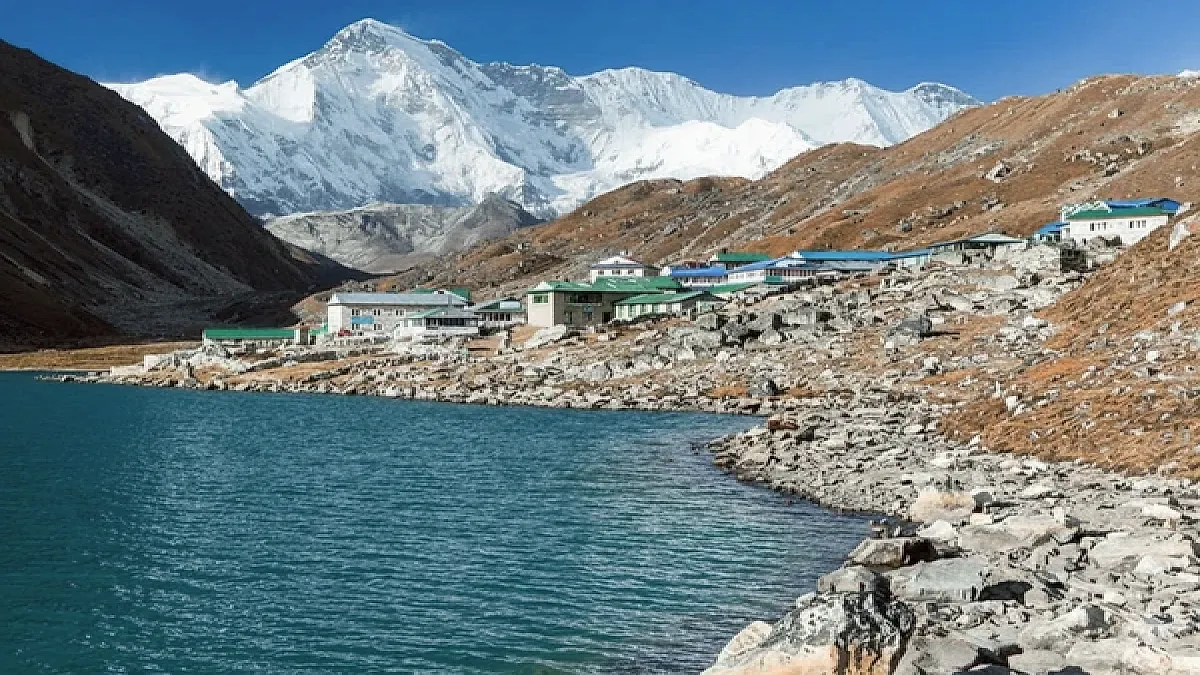
The landscape between Gokyo and Lungden is high-altitude moraine, rock, rubble, and the occasional glacial tarn reflecting the peaks above. The Ngozumpa Glacier, the longest in Nepal, is visible to the east, its debris-covered surface stretching south like a frozen highway of grey rubble. The peaks above, Renjo (5,360m is actually a ridge, not a peak), Dragmarpo Ri, and the unnamed mountains of the Gokyo watershed, are close and steep, their ice faces catching the afternoon light in blues and whites that the grey moraine below does not prepare you for.
The Teahouse
Lungden has one teahouse. Sometimes two, depending on the season and the operator's willingness to keep a facility at 4,380 metres supplied and staffed. The teahouse is basic in the way that all high-altitude teahouses are basic, stone walls, tin roof, small rooms, thin mattresses, a common room with a stove that burns yak dung, and a menu that is dal bhat or noodle soup and nothing else.
The night at Lungden is cold. Minus ten to minus fifteen in October. The sleeping bag that was adequate at Gokyo may feel insufficient here, the combination of altitude, wind exposure, and the single-walled construction of the teahouse allows the exterior temperature to penetrate the interior by midnight. Sleep in every layer you have. Use your down jacket as an additional blanket over your sleeping bag. And accept that sleep at Lungden is not rest but time spent horizontal in the dark while your body does the altitude adaptation that rest cannot accelerate.
What Is It Like to Cross Renjo La Pass?
The alarm, or the guide's knock, comes at three in the morning. Tea and biscuits in the common room where the stove went out at midnight and the temperature is minus ten. Every layer. Headlamp. Water bottles in insulated covers. And walking.
The climb from Lungden to Renjo La gains approximately 980 metres over three to four hours. The trail follows the valley northwest, climbing steeply through moraine and scree. The gradient is sustained, no flat sections, no respite, and the altitude makes every step an act of will. The breathing is loud. The heartbeat is fast. The headlamp illuminates ten metres of trail at a time, and the world shrinks to that circle of light and the cairns that mark the route.
Dawn arrives at approximately five-thirty, the sky lightening in the east, the peaks emerging from darkness, and the pass becoming visible above as a notch in the ridge marked by prayer flags. The final approach is the steepest, loose scree that slides underfoot, requiring concentration and trekking poles for stability. And then the pass.
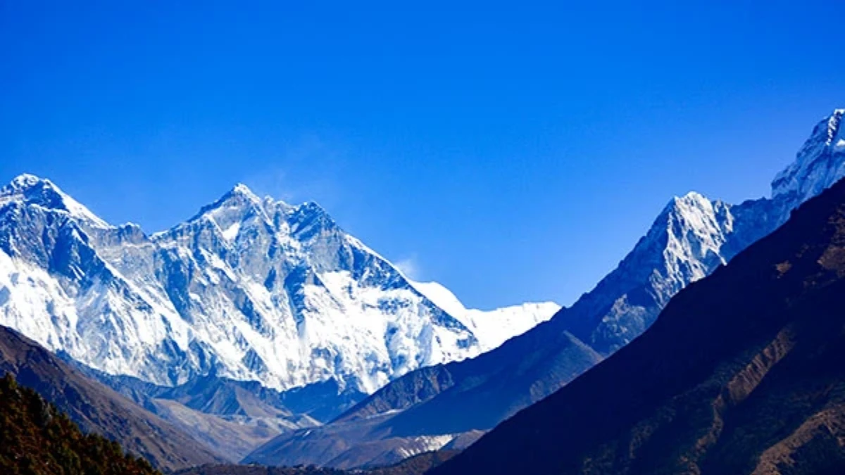
Renjo La at 5,360 metres. Prayer flags. Wind. And the view, east to the Gokyo Lakes, turquoise and perfect far below. West to the Thame Valley, green and gentle, dropping away toward Namche and civilisation. North to the ice peaks of the Khumbu watershed. South to the Ngozumpa Glacier and the Everest region beyond. The panorama is, by many accounts, the finest of the three passes, not the highest (Kongma La has that) and not the most dramatic (Cho La's glacier earns that distinction), but the most complete. The entire Khumbu, from Everest to Gokyo to Thame, is visible in a single sweep.
The descent to the west is steep but non-technical, loose rock and scree for the first hour, then a defined trail that drops into the Thame Valley through terrain that greens with each hundred metres lost. By mid-afternoon, you are in Thame or Marlung, in forest, at 3,800 metres, breathing air that feels rich and warm and impossibly generous after the thin, cold atmosphere of the pass.
What Do You Need to Know Before Crossing Renjo La?
Altitude: Lungden 4,380m. Renjo La 5,360m. Crossing day gains approximately 980m then descends approximately 1,560m to Thame (3,820m).
Duration: three to four hours up to the pass, three to four hours down to Thame. Total crossing day: seven to nine hours.
Season: October-November (best, least snow, most stable weather). March-May (possible, more snow on the pass approach). The pass may be impassable in winter (December-February) due to snow.
Gear: warm layers for minus fifteen, headlamp, trekking poles (essential for the scree), microspikes (recommended for icy sections in early season), two litres of water in insulated bottles.
Prerequisites: the Three Passes trek requires fifteen to twenty days, prior high-altitude trekking experience, and fitness for sustained days at 5,000+ metres. It is not suitable for first-time Nepal trekkers.
The Last Pass
For Three Passes trekkers, Renjo La is the end. Not the end of the walk, Namche is two days below, and Lukla two days below that. But the end of the high crossings. The end of the cold nights. The end of the pre-dawn starts and the headlamp climbs and the prayer flags at the top. Kongma La, Cho La, Renjo La, three passes above 5,300 metres, are behind you. The body that climbed them is tired in a way that the word "tired" cannot capture. And the satisfaction, standing at the third and final pass, looking at the Khumbu spread below in every direction, knowing that you crossed every high ridge the region contains, is the satisfaction of completion. Not just of a trek but of a challenge that only a few thousand people attempt each year and that fewer complete.
Lungden is the last cold night. Renjo La is the last high pass. And the descent to Thame, through forest, through warmth, through air that fills the lungs without resistance, is the beginning of the end of the greatest trekking circuit in the Khumbu. The mountains do not care that you crossed them. But you do. And the knowledge, carried from 5,360 metres at Renjo La through the green valleys to Namche and home, is the knowledge that you walked across the roof of the world, three times, and that the roof held.
Lungden is the camp before Renjo La Pass on the Everest Three Passes Trek. For a shorter route that includes Renjo La without the other two passes, the Everest Two Passes Trek covers Renjo La and Cho La in 15 days.
Lungden is the last stop before Renjo La Pass, and it sits in a valley so quiet that the sound of your own breathing feels loud. The lodge is small, the altitude is 4,380 metres, and tomorrow you cross one of the three great Everest passes. The view from Renjo La — Gokyo Lakes spread out below, Everest and Cho Oyu above — is one of the finest in all of Nepal.
Lungden is on our Everest Three Passes Trek.
WhatsApp:+977 9810351300
Email:[email protected]
Written by Shreejan Simkhada, CEO of The Everest Holiday and third-generation Himalayan guide. TAAN Member #1586.
Lungden is the staging camp for Renjo La pass. Our EBC, Gokyo Lakes & Cho La Pass Trek is private (your group only, no strangers), 2026 dates open, From USD $1599. WhatsApp us for tailored 2026 dates and current departures.