Kangpachen Village, Where the Valley Opens and Jannu Takes Your Breath
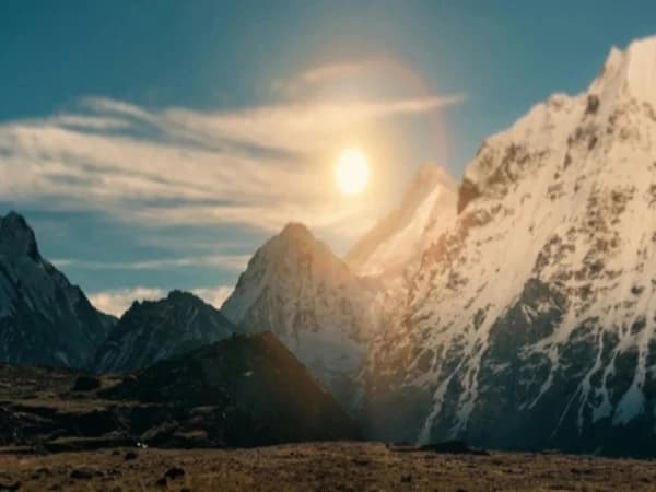
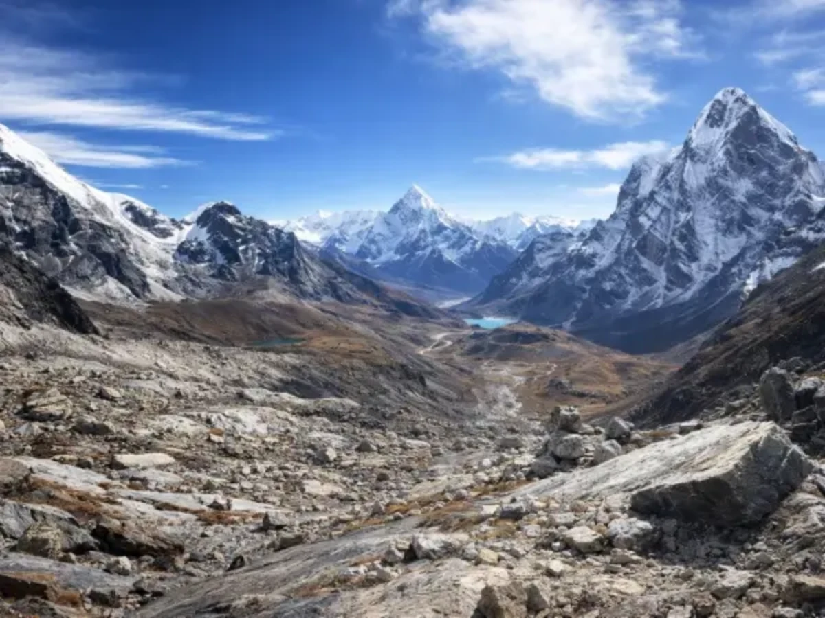
The first thing you see is not the village. It's the mountain. You've been walking north from Ghunsa for five or six hours, following the Ghunsa Khola through narrowing forest that has been thinning all morning, rhododendron giving way to juniper, juniper giving way to scrub, scrub giving way to nothing but rock and the bleached yellow grass of high alpine pasture. And then the valley widens. The walls pull apart. The sky doubles in size. And there, filling the northern horizon with a geometry so steep it looks engineered, is Jannu.
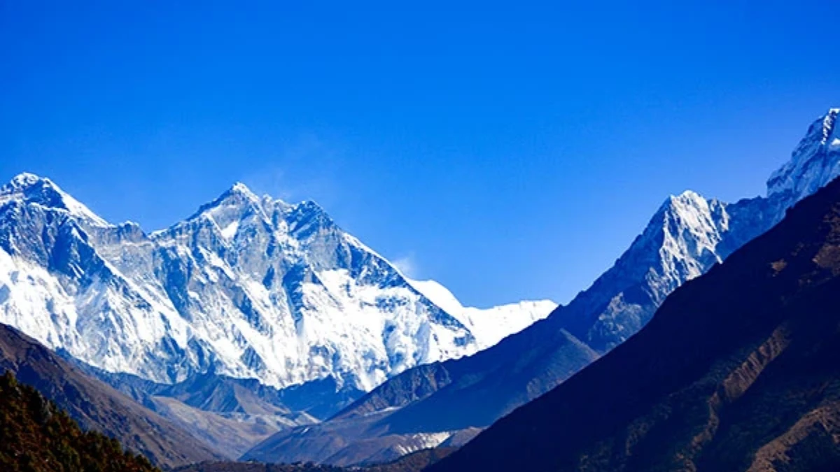
Kumbhakarna. 7,711 metres. A fortress of ice and granite with near-vertical walls on three sides and a summit pyramid that catches the afternoon light while the valley floor is already in shadow. You've seen photographs of Jannu, perhaps, it's one of the most photographed peaks in the Himalaya for the simple reason that it is one of the most dramatic. But photographs flatten it. They remove the sound, the distant crack and rumble of ice calving from the north face. They remove the scale, the fact that the summit is nearly four vertical kilometres above where you're standing. And they remove the air, which at 4,050 metres is thin enough that the mountain seems closer than physics should allow, the details of its face, seracs, crevasses, the blue veins of compressed ice, visible without binoculars in the crystalline atmosphere.
Kangpachen sits below this mountain. A handful of stone buildings on a flat terrace above the river, surrounded by yak pasture that extends to the moraine walls on either side. It is the last significant settlement before Kanchenjunga North Base Camp, the final place where people live (seasonally, at least), where teahouses serve food that was cooked on a stove rather than a camp burner, and where the trail still feels like a trail rather than a route through glacial debris.
Fewer than 1,500 trekkers reach Kangpachen in a typical year. Most of them stay one or two nights. And most of them, when asked later what they remember from the Kanchenjunga trek, mention this place, not Pangpema, not Lhonak, not the base camp itself, but the moment they walked into this valley and saw Jannu for the first time from a distance that made the mountain feel personal.
How Long Is the Walk from Ghunsa to Kangpachen?
The walk from Ghunsa (3,595 metres) to Kangpachen (4,050 metres) takes five to six hours and gains roughly 455 metres. The numbers are modest. The experience is not.
The trail follows the Ghunsa Khola north, climbing gradually through the upper valley. For the first hour, the landscape is still recognisably the world of Ghunsa, scattered juniper, birch forest, the occasional stone wall marking an old yak enclosure. Prayer flags cross the trail at intervals, their colours faded by wind and ultraviolet to the specific pale pastels that prayer flags reach at altitude after a season of exposure.
After two hours, the tree line ends. Not gradually, there is no gentle thinning, no alpine meadow transition. The forest simply stops, replaced by a landscape of rock, grass, and the grey-brown rubble of lateral moraine. The river drops below, audible but increasingly distant as the trail climbs the valley's eastern flank. The wind, which the forest dampened, arrives with its full high-altitude force, constant, cold, and carrying the particular mineral smell of glacial dust.
The middle section of the walk crosses several side streams that drain the glaciers above. In autumn, these are manageable, ankle-deep, cold, running over smooth rock. In spring, after the winter snowmelt begins, they can be knee-deep and fast enough to require careful crossing. Your guide will know which crossings are safe and which require detours. This is one of the practical realities of the Kanchenjunga trek that distinguishes it from the popular routes: the trail changes with the season, and local knowledge is not a luxury but a requirement.
The final hour is the most beautiful. The valley opens into a broad glacial flat, perhaps a kilometre wide, flanked by moraine ridges and the ice-draped walls of unnamed six-thousanders. The grass here is the yellow-gold of high alpine pasture, cropped short by yak that you'll hear before you see, their bells carrying across the flat ground with a clarity that the thin air preserves. And ahead, growing larger with every step, is Jannu, the mountain that has been present since Ghunsa but that only here, in this opened valley, reveals its full vertical architecture.
Kangpachen appears on the right, a cluster of stone buildings that you could miss if you weren't looking for them, so completely do they blend into the moraine behind. Smoke rises from one or two chimneys. A line of prayer flags connects the buildings to a small chorten above the trail. And beyond the village, the valley continues north toward Lhonak and Pangpema, towards the ice, the moraine, and the base camp of the world's third highest mountain.
Who lives in Kangpachen village?
Kangpachen is not a village in the way that Ghunsa or Namche are villages. It has no school, no health post, no monastery. What it has is four or five stone buildings, some used as seasonal dwellings by Sherpa yak herders, some converted to basic teahouse lodges for the trekkers who pass through between September and November, and again between March and May.
The people who live here seasonally are Sherpa, culturally, linguistically, and religiously connected to the Sherpa communities of the Khumbu, the Rolwaling, and the upper valleys of eastern Nepal. Their primary livelihood is yak herding, which at this altitude means a life governed by the movement of animals between summer pastures above 4,000 metres and winter pastures in the valleys below. The yak herds graze the broad flats around Kambachen from May to October, producing milk, butter, and cheese that sustain the herders and, in small quantities, supply the teahouses that serve trekkers.
Buddhism here is not performative. There is no gompa at Kangpachen, the nearest monastery is at Ghunsa, but the chortens, mani stones, and prayer flags that mark the settlement are maintained with quiet devotion. You'll pass a mani wall on the approach, carved stones stacked over decades by hands that walked this trail long before trekkers did. Walk to its left, as tradition requires. The carved mantras, Om Mani Padme Hum, most commonly, face the trail, and the stones carry the particular smooth-edged weathering of objects that have spent years in wind and sun at four thousand metres.
The teahouse accommodation at Kangpachen is basic. Simple rooms with thin mattresses, sometimes a common dining area with a stove fuelled by dried yak dung or carried wood. The menu is limited, dal bhat, noodle soup, potatoes, chapati, tea. Expect to pay more than you would at lower elevations; everything here was carried on the backs of porters or yak from Ghunsa or below. Charging facilities for electronics are unreliable. Mobile signal is absent. The specific disconnection of a place that is seven days' walk from the nearest road is total at Kambachen.
How tall is Mount Jannu?
Mountains are usually seen from a distance. You admire them from a viewpoint, photograph them from a ridge, watch them change colour at sunrise from the window of a teahouse. Jannu, from Kambachen, is different. The mountain doesn't sit on the horizon. It fills the sky.
Kumbhakarna, the mountain's Nepali name, after the sleeping giant of Hindu mythology, rises directly north of the village. Its north face is one of the great walls of the Himalaya: nearly 3,000 metres of ice-coated granite, vertical in places, overhanging in others, crowned by a summit that the first French expedition reached in 1962 after what climbers describe as one of the most demanding ascents of the era. The face has since been climbed by a handful of elite expeditions, and from Kambachen the routes are traceable, tiny lines on a massive canvas of rock and ice.
What makes the view from Kangpachen special is proximity. You're not ten or twenty kilometres from the face. You're perhaps five. Close enough to see individual seracs, house-sized blocks of ice perched on the face, blue-white against the grey rock. Close enough to hear them fall. The sound arrives seconds after the visual, a distant crack, then a rolling thunder that echoes between the valley walls and fades into the wind. It happens several times a day, especially in the afternoon when the sun warms the face and the ice loosens its grip on the rock.
At dawn, the sequence is this: the summit catches the first light while the valley is still dark. The ice turns gold. The gold spreads down the face as the sun rises, and for approximately ten minutes the entire north wall is lit in a colour that photography never quite captures, warm, amber, alive, while the valley floor remains in cold blue shadow. The temperature difference between sunlit summit and shadowed valley is perhaps forty degrees. The contrast between the two worlds, the warm light above, the frozen ground below, is one of those Himalayan moments that makes the seven days of walking that brought you here feel like a reasonable exchange.
In the evening, the mountain performs in reverse. The sun drops behind the western ridge, and the shadow climbs the face, extinguishing the light from bottom to top, until only the summit pyramid is lit, then only the tip, then nothing. The temperature drops immediately. You retreat to the teahouse, to the stove, to the tea that the lodge keeper has been brewing in anticipation of this moment. Outside, Jannu disappears into the darkening sky, visible only as an absence of stars, a black shape where the Milky Way should be.
Why is Kangpachen important for acclimatisation?
Kangpachen is not just a pretty camp. It's a critical acclimatisation stop, and the trekkers who skip it, or rush through it, are the ones who suffer at Lhonak and Pangpema.
The altitude profile of the Kanchenjunga trek is demanding. From Ghunsa (3,595 metres) to Pangpema (5,143 metres), you gain over 1,500 metres in three to four days. Without adequate acclimatisation, this rate of ascent is a reliable trigger for acute mountain sickness, headache, nausea, fatigue, and in severe cases, the pulmonary or cerebral oedema that can become life-threatening within hours.
The standard and strongly recommended itinerary includes one rest day at Kangpachen, a full day at 4,050 metres before continuing to Lhonak (4,780 metres) and then Pangpema. This rest day follows the same principle used at Namche Bazaar on the EBC trek and at Samagaon on the Manaslu Circuit: sleep at the same altitude for two consecutive nights, allowing your body to increase red blood cell production and adjust to the reduced oxygen.
On your acclimatisation day, the standard hike climbs north toward Lhonak for two to three hours, reaching approximately 4,400 to 4,500 metres, before returning to Kangpachen to sleep. The climb high, sleep low principle. The trail follows the river valley through increasingly barren moraine, with views that improve with every hundred metres of elevation gained. Some guides offer an alternative: a hike to the lateral moraine ridge east of the village, which provides panoramic views of both Jannu and the Kanchenjunga Glacier without the distance commitment of the Lhonak trail.
Monitor yourself during the acclimatisation day. Mild headache is normal at 4,050 metres. Loss of appetite is common. Difficulty sleeping, the periodic breathing that altitude produces, where your body alternates between deep breaths and shallow ones in a rhythm that wakes you repeatedly, is expected. These are normal responses. What is not normal is severe headache that does not respond to paracetamol, persistent vomiting, confusion, or difficulty with balance. Any of these symptoms means descent. Not tomorrow. Now. Your guide carries a pulse oximetre and will check your oxygen saturation, anything below 80 percent at rest warrants attention, anything below 70 warrants immediate descent to Ghunsa.
The acclimatisation day at Kangpachen is also, frankly, a pleasure. After five or six days of continuous walking, a day without a heavy pack, without a destination, without the pressure of distance, a day to sit in the sun (if the weather cooperates), drink tea, watch the yak graze, and simply be present in one of the most beautiful valleys in Nepal, is a gift. Take it. Your body needs it. Your mind, which has been focused on the logistics of walking for a week, needs it too.
What is the best time to visit Kangpachen?
Kangpachen has two trekking seasons, and they're different enough to be worth understanding.
Autumn (late September to mid-November) is the classic season. The monsoon has cleared, the air is clean, and the views are at their best. Daytime temperatures at 4,050 metres reach five to ten degrees Celsius in October. Night temperatures drop to minus five to minus fifteen. The sky is reliably clear for the first three weeks of October, with clouds building in the afternoons as the season progresses. This is when most trekkers come, and "most" at Kambachen means perhaps five to ten people on any given day.
Spring (late March to mid-May) brings warmer temperatures but hazier skies. The lower valleys are alive with rhododendron bloom, the forests between Taplejung and Ghunsa are spectacular in April, but at Kambachen's altitude, spring means snowmelt, swollen streams, and the occasional late-season snowfall that can close the trail to Lhonak for a day or two. The views of Jannu are still extraordinary, but the crystal clarity of autumn is replaced by the softer light of spring haze.
Winter (December to February) is not recommended. Temperatures at Kangpachen drop to minus twenty or below. The teahouses close. The trail above Ghunsa may be snow-covered and impassable. The yak herders descend to lower pastures. Kangpachen in winter is not a trekking destination, it is a frozen, uninhabited high-altitude flat where survival requires expedition-level equipment and experience.
Wind is the constant at any season. The valley funnels air from the glaciers above, and by mid-afternoon the wind at Kangpachen is strong enough to make standing in the open uncomfortable. Bring a windproof layer. Bring a warm hat. Bring gloves that you can wear while still holding trekking poles. The wind chill at 4,050 metres with a twenty-kilometre-per-hour breeze, which is an average afternoon, drops the effective temperature by ten to fifteen degrees below what the thermometre reads.
Are there snow leopards near Kangpachen village?
The upper Ghunsa Khola valley, from Ghunsa to Pangpema, is confirmed snow leopard habitat. The Kanchenjunga Conservation Area, which encompasses the entire trek, supports an estimated population of snow leopards that prey on the blue sheep (bharal) herds grazing the high meadows and moraine slopes.
Will you see one? Almost certainly not. Snow leopards are among the most elusive large predators on earth, and even researchers who spend months in confirmed habitat consider a sighting exceptional. But the evidence of their presence is everywhere at Kambachen. Scrape marks on rocks. Scat on prominent boulders, the territorial markers of an animal that patrols a range of dozens of square kilometres. And the blue sheep themselves, visible on the slopes above the village in groups of ten to thirty, grazing the steep terrain with an indifference to gravity that is genuinely startling to watch.
The bharal are your most reliable wildlife sighting at Kangpachen. They graze the slopes above and across the river, and in the early morning and late afternoon they descend to the valley edges. Watch for them on the moraine ridges to the east of the village, grey-brown shapes against grey-brown rock, nearly invisible until they move. Other wildlife in the area includes Himalayan tahr, pikas (small, round, extraordinarily cute mammals that live in the rock fields and announce your presence with a sharp whistle), and a variety of raptors, lammergeier, golden eagle, and the Himalayan griffon vulture, which rides the thermals above the valley with a wingspan of nearly three metres.
If you're a birdwatcher, bring binoculars. The valley between Ghunsa and Kangpachen is particularly good for grandala, a striking blue thrush that flocks in the hundreds at altitude, and for the various rosefinches and accentors that inhabit the scrub zone between tree line and bare rock.
What Should You Know About Kambachen?
Water: The streams at Kangpachen are glacial, clean, cold, and safe to drink when treated. Bring purification tablets or a filter. Don't rely on bottled water above Ghunsa, it's carried in by porter and costs accordingly.
Charging: Don't count on it. Bring a portable battery sufficient for your camera and phone for the days between Ghunsa and your return. Solar charging is possible if you carry a panel, but the afternoon clouds and the valley's orientation limit its reliability.
Toilets: Basic. Pit latrines at the teahouses. Carry hand sanitiser.
What to carry from Ghunsa: Snacks, chocolate, nuts, energy bars. The teahouse food at Kangpachen is adequate but monotonous, and having something different in your pocket for the acclimatisation hike makes the day better. Also carry enough warm layers to be comfortable standing still in wind for an hour, the acclimatisation hike involves stopping to admire the view, and standing still at 4,400 metres in wind is dramatically colder than walking.
Sleeping bag: You need a bag rated to minus fifteen at minimum for Kangpachen, and minus twenty if continuing to Lhonak and Pangpema. The teahouses provide blankets, but at this altitude and with the wind that penetrates the stone walls, your own insulation is essential.
Photography: Bring spare batteries and keep them warm, inside your jacket, against your body. Cold drains lithium batteries rapidly at altitude. The best light on Jannu is at dawn (east-facing light on the north wall) and late afternoon (warm side light that reveals the face's texture). Midday light is flat and harsh. A polarising filter helps with the high-altitude glare.
How do you trek from Kangpachen to Lhonak?
From Kangpachen, the trail continues north to Lhonak (4,780 metres), a walk of five to six hours through increasingly barren glacial moraine. The vegetation ends within an hour of Kangpachen. The valley narrows. The river, now a glacial stream, runs grey with sediment. And the landscape becomes the high-altitude desert that characterises the approach to Pangpema, rock, ice, and the particular silence of a valley that has been scraped clean by glaciers over millennia.
Lhonak is not a village. It's three or four stone shelters on a moraine flat, survival accommodation for the night before the base camp push. The drop in comfort from Kambachen to Lhonak is significant, and the drop in temperature more so. Kambachen, in retrospect, will feel like civilisation.
This is part of what makes Kangpachen memorable. It's the last warmth. The last stove that someone else lit. The last dal bhat cooked in a kitchen rather than assembled from carried provisions on a camp burner. The last place where you can sit outside in the afternoon sun, watch yak graze, listen to their bells, and feel, despite being seven days' walk from the nearest road, at four thousand metres, in a valley that fewer than two thousand people visit each year, something close to comfort.
Above Kangpachen, comfort ends and the mountain begins. Kangpachen is the threshold between the two, the place where the trek pauses, gathers its strength, adjusts its blood chemistry, and prepares for the ice and altitude above. It's a place you'll remember long after you've forgotten the details of the trail below, not because it's the most dramatic point on the trek, but because it's the place where you sat still long enough for the valley's beauty to settle into you, where Jannu's face was close enough to hear, and where the last warmth of the inhabited world met the first cold of the glacial one.
Kangpachen is a high camp on the approach to Kanchenjunga North Base Camp on the Kanchenjunga Base Camp Trek (19 days).
Kangpachen is one of the most remote places you can trek to in Nepal. The village sits at the foot of Kanchenjunga's north face, and the handful of stone houses, the prayer flags, and the yak pastures feel like the edge of the known world. Getting here takes days of walking through forests that nobody else is walking through. That is the whole point.
Kangpachen is on our Kanchenjunga Base Camp Trek. We send our most experienced guides on this route — it demands it.
WhatsApp:+977 9810351300
Email:[email protected]
Written by Shreejan Simkhada, CEO of The Everest Holiday and third-generation Himalayan guide. TAAN Member #1586.
Kangpachen is the gateway to Kanchenjunga Base Camp. Our Kanchenjunga Base Camp Trek (19 Days) is private (your group only, no strangers), 2026 dates open, From USD $2499. WhatsApp us for tailored 2026 dates and current departures.