
Ghyaru on the Annapurna Circuit: The High Route Village Above Upper Pisang

Last updated 14 October 2026.
Ghyaru is the village on the high route above Upper Pisang, and it is the reason I send most Annapurna Circuit trekkers up the hill rather than along the river. It is a small, flat-roofed stone village on a ridge at about 3,730 m, with the Annapurna range laid out across the south. Most people on the Circuit never see it because the low route is quicker. I think they miss the best morning of the trek.
Short answer: Ghyaru sits at about 3,730 m (12,240 ft), a steep climb of roughly 430 m above Upper Pisang at 3,300 m. You pass through it on day 5 or 6 of our Annapurna Circuit Trek, 12 days, on the high route to Ngawal and then down to Manang at 3,540 m. The day is 5 to 7 hours, longer and harder than the low route, and your guide chooses it on the morning depending on weather and how everyone feels. The reward is a continuous view of Annapurna II, III, IV and Gangapurna. We do not sleep in Ghyaru on our itineraries. We walk through it.
I want you to know what you are signing up for before you leave Upper Pisang, because the choice of route is made at breakfast, and the climb starts straight away.
Ghyaru at a glance
| Item | What to know |
|---|---|
| Altitude | About 3,730 m (12,240 ft) |
| Where | On the high route between Upper Pisang and Ngawal, in the Manang district of the Annapurna Conservation Area |
| Climb from Upper Pisang | About 4.5 km of switchbacks, from 3,300 m up to about 3,730 m |
| Whole day to Manang | 5 to 7 hours by the high route, ending in Manang at 3,540 m |
| The view | Annapurna II, III, IV and Gangapurna across the valley |
| On our itineraries | A walk-through, not a night stop |
| Permits | Annapurna Conservation Area permit and TIMS card, both included in our price |
| Best months | October to November, then March to May |
Which of our trips go through Ghyaru?
| Trip | Where it falls |
|---|---|
| Annapurna Circuit Trek, 12 days | Day 6, Upper Pisang to Manang by the high route |
| Annapurna Circuit with Tilicho Lake, 14 days | Day 5, Upper Pisang to Manang |
| Annapurna Circuit Trek with Tilicho Lake, 16 days | Day 5, Upper Pisang to Manang |
| Chulu West Peak Climbing, 15 days | Day 5, the approach to Manang |
| Pisang Peak Climbing, 14 days | Day 5, on the way to Manang |
For 2 to 4 people the 12-day Annapurna Circuit is USD 1,175 (Budget), USD 2,030 (Standard) or USD 2,690 (Luxury) per person, and the 16-day trek with Tilicho Lake is USD 1,495, USD 2,610 or USD 3,340. The price falls as the group grows, and I list every band on the package pages. Kathmandu hotels are not in a trek price. All are walked privately with your own licensed guide.
What is the climb from Upper Pisang like?
Steep, and it starts early. From Upper Pisang the trail leaves the village and zigzags up the hillside for about 4.5 km. You gain roughly 430 m, and you do it at a height where every step feels slower than at home. Go at the pace of the slowest person and stop when you are out of breath. Your guide has done this climb many times and will tell you when to rest.
The view builds as you go. Each turn of the path opens a little more of the Annapurna range. When you reach Ghyaru you are in a small stone village on the ridge. Wikivoyage lists the view as sweeping, across Annapurna II, III, IV and Gangapurna, and I agree with it. This is where I tell people to take the photographs, because the next hours are about walking.
My piece on Pisang village describes where you sleep the night before, and the choice between the two Pisangs.
How long is the walk from Ghyaru to Ngawal and Manang?
The ridge walk from Ghyaru to Ngawal takes three to four hours, as I describe in my Pisang guide. It is mostly along the ridge rather than up it, so it is easier than the climb out of Upper Pisang. At Ngawal, at about 3,660 m, the trail comes down towards Manang. I describe the village in my guide to Ngawal.
The whole day is 5 to 7 hours, and about 16 km on our package page. Wikivoyage gives the high route as about 6 hours 30 minutes and 19.5 km, against 4 hours 15 minutes and 15 km by the lower route through Lower Pisang. The two sources do not agree on the distance, so plan for a long day and carry lunch and water. I do not rely on any one stop along the ridge being open, and neither should you.
You end the day in Manang at 3,540 m. My Manang guide tells you what to do on your rest day there.
Is the high route right for you?
| Question | High route through Ghyaru | Low route by the river |
|---|---|---|
| Time | 5 to 7 hours | Shorter, about 4 hours 15 minutes by Wikivoyage's count |
| Effort | Steep climb out of Upper Pisang, then ridge | Easier, mostly flat |
| Highest point of the day | About 3,730 m | Lower, through Humde at about 3,330 m |
| Views | Annapurna range most of the day | Valley walls close in, with fewer open views |
| Best for | Good weather, a rested group | Cloud, rain, tired legs, or a late start |
I never promise the high route. Weather, snow and how the group feels decide it, and I would rather take the low route than push someone who is unwell. Going higher by day and sleeping lower in Manang is also good for acclimatisation, and my acclimatisation guide explains why.
What is the road and trail position this autumn?
The Besisahar to Chame road was damaged in the September flood and is repaired and open to vehicles again as of 14 October 2026. The trail itself is fine. A blocked road is not a blocked trail, and my page on whether the Annapurna Circuit is open goes through it. We check the road and the trail 48 hours before departure, and if a road is not open we move your dates free of charge.
When is the best time to walk through Ghyaru?
| Months | What it is like |
|---|---|
| October to November | The clearest skies and the steadiest weather. The best months for the view |
| December to February | Very cold at this height, with snow possible |
| March to May | A good season, with clear mornings the best part of the day |
| June to September | Monsoon. Rain and cloud, so the view is not what you came for |
For 2027 my pick is the second half of October or April. If you want to compare the seasons, read my autumn guide to the Annapurna Circuit.
Insurance
Buy your insurance at home. It must cover trekking and helicopter rescue up to 5,500 m, which covers Thorong La. I advise against policies bought in Nepal.
Questions people ask
Where is Ghyaru? In the Manang district, above Upper Pisang on the high route of the Annapurna Circuit, between Upper Pisang and Ngawal.
How high is Ghyaru? About 3,730 m (12,240 ft).
How long is the climb from Upper Pisang to Ghyaru? About 4.5 km of switchbacks, climbing roughly 430 m from Upper Pisang at 3,300 m.
Is the high route through Ghyaru worth it? In clear weather, yes. It has the best views of the Annapurna range on the whole Circuit.
Can altitude sickness affect me on this day? You top out at about 3,730 m and sleep lower, in Manang at 3,540 m. It is a hard day, so walk slowly, drink well and tell your guide early. We check your oxygen in the evening.
Can I sleep in Ghyaru? Our itineraries do not stop there. If you want a night, ask me and I will say what I know at the time.
Can I take the low route instead? Yes. Your guide chooses the route on the morning, and I would always rather take the easier path than push an unwell trekker.
Do I need a permit for Ghyaru? You need the Annapurna Conservation Area permit and a TIMS card. Both are included in our price.
What are the terms for this trek?
Group size is 2 to 20, and you can also trek solo. The deposit is 10 per cent and it is non-refundable, with no refund if you cancel. You can reschedule free of charge with at least 72 hours notice to any date within one year. The balance is paid on arrival in Kathmandu in USD or EUR, cash or by card. Card carries 3.5 per cent and cash in Kathmandu carries none. We do not take Nepali rupees from foreign clients.
How do you plan this with us?
Message me on WhatsApp on +977 9810351300 with your dates, how many of you there are and which Annapurna Circuit length you have in mind. I will tell you which tier and which route I would choose, and send you the exact quote.
Written by Shreejan Simkhada, CEO of The Everest Holiday, from a family of three generations of family guides. TAAN Member #1586. WhatsApp +977 9810351300.
Planning a trip to Nepal?
Drop us your details and tell us what you have in mind. We will put together a personalised plan and get back to you.
Not sure which Nepal trek is right for you?
Take our free 2-minute quiz and get personalised recommendations based on your fitness, experience, and travel style.
Find Your Perfect Trek →
Trek Plus Chitwan Jungle and Trishuli Rafting in One Trip: The 8 and 9 Day Combinations Compared
Poon Hill or Mardi Himal with a Chitwan jungle safari, and Trishuli rafting as an option: three 8 and 9 day trips compared day by day, with prices for solo, two to four and five to eight guests, best months and how to get between the places.
Read More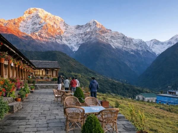
Kimche on the Annapurna Base Camp Trail: The Jeep Drop-Off and Gurung Village Before Ghandruk
Kimche is the Gurung village where the jeep from Nayapul stops and the stone steps to Ghandruk begin. It saves about 90 minutes of road walking. Here is what to expect on day one.
Read More
Everest View Trek in 5 or 7 Days: Which to Choose, What Each Costs and What You See
Everest View Trek in 5 or 7 days: the day-by-day route, how high you go, what each costs for solo, two to four and five to eight guests, and which one I would choose.
Read More Chat with Shreejan