Nepal Travel Guide & Expert Trekking Tips
Everest Three Passes Trek Map 2027: Route, Stops and Heights Day by Day

Updated 4 November 2026.
Short answer: The Everest Three Passes is a loop through the Khumbu. You walk from Namche to Thame, cross Renjo La (5,360 m) to Gokyo, cross Cho La (5,420 m) to Dzongla, reach Everest Base Camp (5,364 m) and Kala Patthar (5,545 m), then cross Kongma La (5,535 m) to Chhukung and walk out. Our plan is 17 days. It costs from USD 1,460 Budget, USD 2,960 Standard and USD 5,835 Luxury per person for two to four people.
I am Shreejan, and I run The Everest Holiday with my family, three generations of family guides. This is the plan we use on our own 17-day Everest Three Passes trek. Every height comes from our itinerary. Our 17-day Everest Three Passes trek page has the full inclusions, or message me on WhatsApp at +977 9810351300.
Everest Three Passes 17-day trek altitude chart
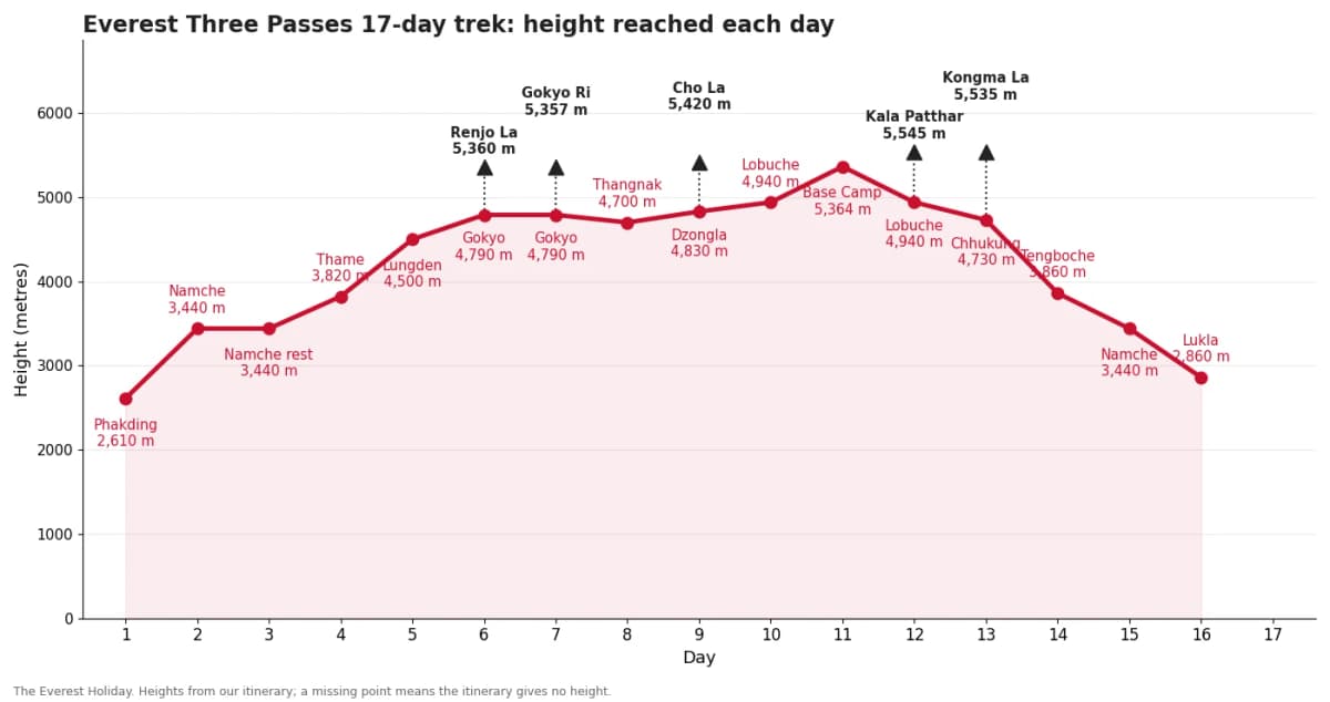
I drew this chart myself from our current itinerary. A missing point means the itinerary gives no height there, and I do not guess. Triangles mark passes and viewpoints. The table below uses the same figures.
Every stop, day by day
| Day | Route | Height reached |
|---|---|---|
| 1 | Fly to Lukla (2,860 m), walk to Phakding | 2,610 m |
| 2 | Phakding to Namche Bazaar | 3,440 m |
| 3 | Acclimatisation in Namche Bazaar | 3,440 m |
| 4 | Namche Bazaar to Thame | 3,820 m |
| 5 | Thame to Lungden | 4,500 m |
| 6 | Lungden over Renjo La to Gokyo | 4,790 m (over Renjo La 5,360 m) |
| 7 | Rest day, Gokyo Ri at sunrise | 4,790 m (over Gokyo Ri 5,357 m) |
| 8 | Gokyo to Thangnak | 4,700 m |
| 9 | Thangnak over Cho La to Dzongla | 4,830 m (over Cho La 5,420 m) |
| 10 | Dzongla to Lobuche | 4,940 m |
| 11 | Lobuche to Everest Base Camp via Gorak Shep | 5,364 m |
| 12 | Kala Patthar at sunrise, return to Lobuche | 4,940 m (over Kala Patthar 5,545 m) |
| 13 | Lobuche over Kongma La to Chhukung | 4,730 m (over Kongma La 5,535 m) |
| 14 | Chhukung to Tengboche | 3,860 m |
| 15 | Tengboche to Namche Bazaar | 3,440 m |
| 16 | Namche Bazaar to Lukla | 2,860 m |
| 17 | Fly Lukla to Kathmandu, transfer to hotel | not given |
What a map does not show
The chart is the clearest picture of why this trek is hard. After Namche you spend most of the trek above 4,000 m, and the three passes are triangles on top of the line. Day 6 crosses Renjo La (5,360 m) and sleeps at Gokyo (4,790 m). Day 9 crosses Cho La (5,420 m) and sleeps at Dzongla (4,830 m). Day 13 crosses Kongma La (5,535 m) and sleeps at Chhukung (4,730 m).
There are two rest days, at Namche on day 3 and at Gokyo on day 7, when you climb Gokyo Ri at sunrise (5,357 m). The highest point of the whole trek is Kala Patthar at 5,545 m, a little higher than Kongma La.
Our itinerary gives no height for Kathmandu on day 17, so that point is left off the chart. Weather matters a lot on the passes. My honest piece on snow odds in November and December explains it.
More reading: Everest Three Passes best time, month by month, snow odds in November and December, Everest Base Camp trek map, Gokyo Lakes trek map.
Best time to walk this route
Spring (March to May) and autumn (October to November) are the usual windows. I go through every month in the best time for the Three Passes.
What this route costs
| Group size | Budget | Standard | Luxury |
|---|---|---|---|
| 1 person | USD 2,210 | USD 3,330 | USD 6,545 |
| 2 to 4 people | USD 1,460 | USD 2,960 | USD 5,835 |
Prices are per person, read from the live trek page on 4 November 2026. Larger groups pay less, and the full table is on the trek page. Insurance should cover helicopter rescue to 6,000 m.
Everest Three Passes 17-day trek map questions
How long is the Everest Three Passes trek?
Our plan is 17 days: from the flight to Lukla to the flight back, with rest days at Namche and Gokyo.
How high are the three passes?
Renjo La 5,360 m, Cho La 5,420 m and Kongma La 5,535 m on our itinerary. Kala Patthar at 5,545 m is the highest point of the trek.
Where does the Three Passes trek start?
With a flight to Lukla (2,860 m), then a walk to Phakding. We finish the same way with a flight back to Kathmandu.
Is the Three Passes route a loop?
Yes. You go up through Thame and Gokyo, cross to Lobuche for Base Camp, and come out through Chhukung, Tengboche and Namche.
How much altitude do I need to insure for?
The highest point is 5,545 m, so your insurance should cover helicopter rescue to at least 6,000 m. Please buy it in your home country.
Do I need to have trekked before?
It is one of the hardest teahouse treks in Nepal. Please message me with your experience and I will tell you honestly if it suits you.
Can I skip one pass?
Yes. We also run a 15-day Everest Base Camp and Gokyo Ri trek without Cho La, which my cost page explains.
If you want to go through the route with me for your own dates, message me on WhatsApp at +977 9810351300.
Planning a trip to Nepal?
Drop us your details and tell us what you have in mind. We will put together a personalised plan and get back to you.
Take our free 2-minute quiz and get personalised recommendations based on your fitness, experience, and travel style.
Find your trekMore from the travel blog
All stories and guides Nepal Travel Guide & Expert Trekking TipsGokyo Lakes Trek Map 2027: Route, Stops and Heights Day by DayOur route chart of the 10-day Gokyo Lakes trek, every stop and height day by day, and what a map leaves out.
 Nepal Travel Guide & Expert Trekking TipsLangtang Valley Trek Map 2027: Route, Stops and Heights Day by DayOur route chart of the 8-day Langtang Valley trek, every stop and height day by day, and what a map leaves out.
 Nepal Travel Guide & Expert Trekking TipsManaslu Circuit Trek Map 2027: Route, Stops and Heights Day by DayOur route chart of the 12-day Manaslu Circuit trek, every stop and height day by day, and what a map leaves out.