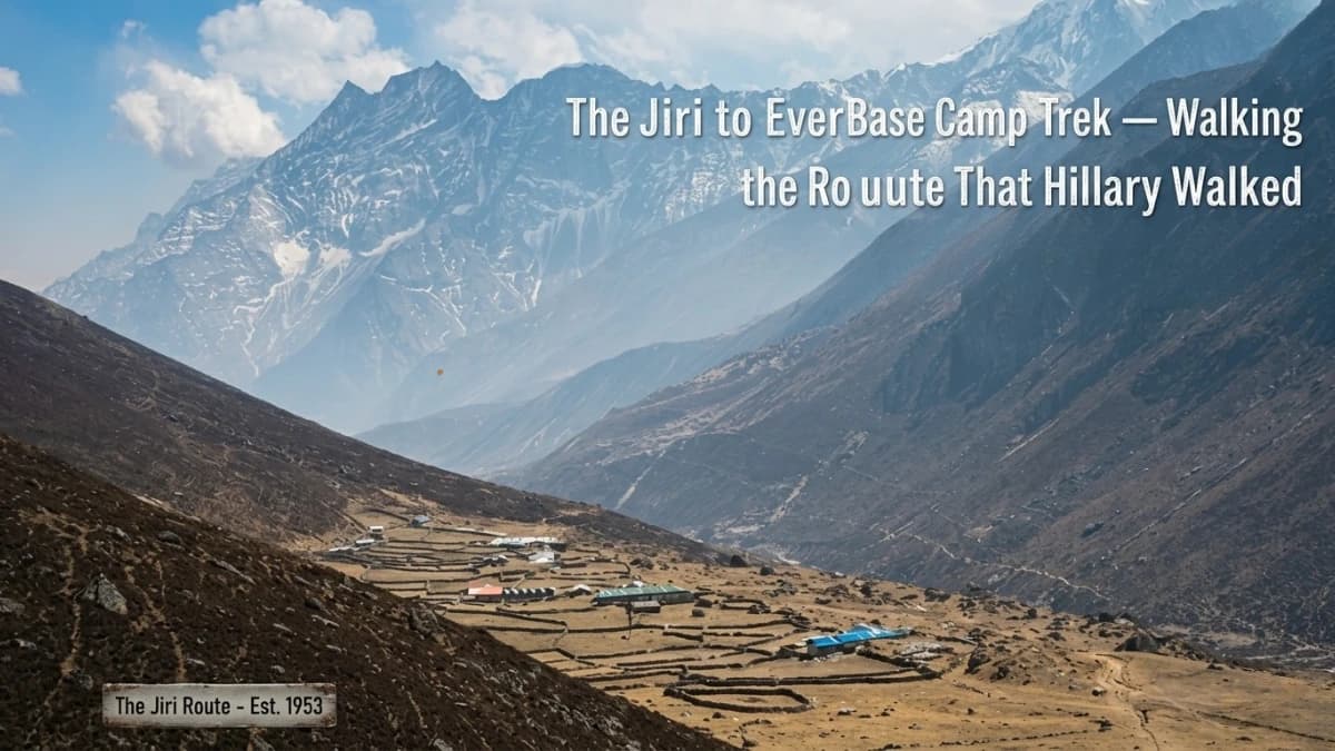
In 1953, Edmund Hillary and Tenzing Norgay did not fly to Lukla. Lukla's airstrip did not exist. It would not exist until 1964, when Hillary himself organised its construction to support a school-building project in the Khumbu. Before the airstrip, there was only one way to reach Everest: walk. From Kathmandu, east through the hills of the Solu-Khumbu, over ridgelines and through river valleys, for two weeks, before the mountain was even visible.
That walk began — for the 1953 expedition and for every Everest expedition before it — from the town of Jiri. A bus ride from Kathmandu, then footsteps. And the footsteps continued for roughly one hundred and ten kilometres through a landscape of terraced rice paddies, rhododendron forests, Rai and Sherpa villages, suspension bridges, monastery bells, and the slow, magnificent unfolding of the Himalaya from distant suggestion to overwhelming presence.
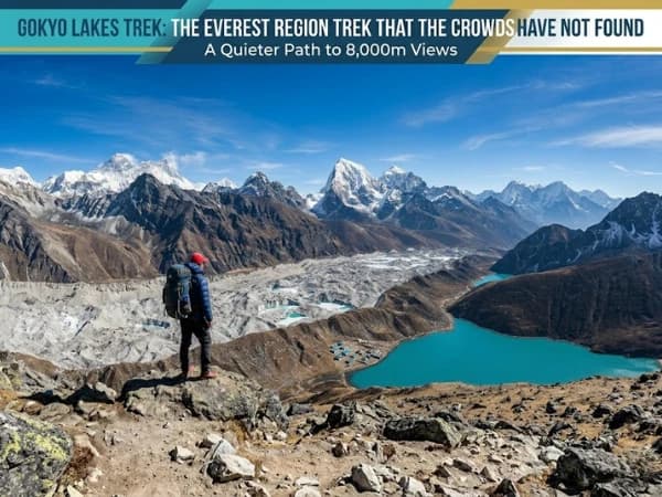
Today, the Jiri to Everest Base Camp trek is the forgotten route. Ninety-five percent of EBC trekkers fly to Lukla and begin walking at 2,840 metres, eight days of walking ahead of them. The remaining five percent — and it may be less — take the bus to Jiri, begin walking at 1,905 metres, and have thirteen to fifteen days of walking ahead, through country that the Lukla trekkers will never see. The forgotten five percent see a different Nepal. A quieter Nepal. A Nepal that looks the way the entire country looked before aviation compressed the approach to Everest into a forty-minute flight.
Why Would You Walk From Jiri Instead of Flying to Lukla?
The question sounds masochistic to the trekker comparing itineraries. Why add five to seven days of walking to a trek that is already twelve days long? Why start at 1,905 metres and cross three major passes — each above 3,500 metres, before even reaching Namche Bazaar, which is where the Lukla trekkers begin?
The answers are layered, and each one matters.
Acclimatisation. The Jiri route is the most natural acclimatisation profile in Himalayan trekking. You start at 1,905 metres and gain altitude gradually over six to seven days before reaching Namche at 3,440 metres. By the time you arrive in Namche, your body has had nearly a week of progressive altitude exposure. The trekker who flies to Lukla arrives at 2,840 metres with zero acclimatisation and must compress the adaptation process into the next four days. The Jiri walker arrives at Namche already acclimatised, already comfortable, already breathing easily at an altitude that makes the Lukla trekker's head pound.
The practical result: Jiri walkers have significantly lower rates of altitude sickness above Namche. The extended approach is not just scenery. It is medicine.

The landscape below the Khumbu. The Solu-Khumbu hills between Jiri and Lukla are some of the most beautiful and least visited terrain in Nepal. Terraced rice paddies cascade down hillsides in emerald steps. Rhododendron forests bloom crimson in spring. Rivers carve deep valleys that the trail crosses on suspension bridges that swing in the wind. The villages, Bhandar, Sete, Junbesi, Nunthala, are traditional Rai and Sherpa settlements where life moves at walking speed and the rhythms of agriculture and monastery prayer have not been disrupted by the trekking industry.
Above Lukla, the trail is busy, hundreds of trekkers per day during peak season, tea houses competing for business, the hum of commerce and logistics that an international trekking destination generates. Below Lukla, on the Jiri route, the trail is quiet. You may walk for hours without seeing another foreign trekker. The teahouses are simpler. The interactions with locals are less transactional. The trip is closer to what trekking in Nepal felt like before it became an industry.
The historical resonance. You are walking the route that every Everest expedition walked before 1964. The 1953 British expedition. The 1952 Swiss expeditions. The 1951 reconnaissance. The pre-war British expeditions approached from Tibet, but every post-war southern approach used this trail. The path your feet follow is the path that carried Hillary, Tenzing, Hunt, Mallory's legacy, and every other name in Everest's history toward the mountain. This is not a marketing line. It is geography. The trail is the same trail. The ridges are the same ridges. The views that unfolded for those climbers as they walked east toward the Khumbu are the views that unfold for you.
The Route: Jiri to Namche
The bus from Kathmandu to Jiri takes seven to nine hours on a road that is paved in sections and unpaved in others. The journey itself is an introduction to Nepal's middle hills, the terraced farmland, the roadside villages, the terrifying competence of Nepali bus drivers on mountain roads. Jiri sits at 1,905 metres in a broad valley, surrounded by pine forests and fields.
Day 1: Jiri to Bhandar (2,040m). The trail climbs out of Jiri through pine and rhododendron forest to the Deurali pass at 2,705 metres, a gain of 800 metres that introduces your legs to the reality of Himalayan trail profiles. The descent to Bhandar is equally steep. Total walking: six to seven hours. This first day establishes the pattern, up and over, down and across, that defines the Jiri route.
Day 2: Bhandar to Sete (2,575m). A descent to the Likhu Khola river at 1,580 metres, then a long climb to Sete. The descent is through terraced farmland where rice and maize grow in the warm valley bottom. The climb takes you through forest and past small settlements. Walking: six to seven hours.
Day 3: Sete to Junbesi (2,675m). Over the Lamjura pass at 3,530 metres, the highest point on the Jiri route before Namche. The pass is marked by prayer flags and, in spring, surrounded by blooming rhododendrons. Junbesi is one of the most beautiful villages on the route, a Sherpa settlement with a monastery, apple orchards, and views of Everest that appear for the first time as a distant white triangle above the nearer ridges. Walking: seven to eight hours.
Day 4: Junbesi to Nunthala (2,194m). Through the Everest viewpoint at Sallung and over the Taksindu pass at 3,071 metres, where the Taksindu monastery sits among ancient trees. The descent to Nunthala is through increasingly Sherpa-influenced settlements. Walking: five to six hours.
Day 5: Nunthala to Kharikhola (2,040m). A long descent to the Dudh Koshi river, the same river you will follow all the way to Everest, and a climb to Kharikhola. The trail passes through Jubing, where the vegetation becomes subtropical again, banana trees, bamboo, and ferns that seem impossible given that you were at 3,500 metres yesterday. Walking: seven to eight hours.
Day 6: Kharikhola to Puiyan or Surke (2,290m). Ascending through forest toward the Khumbu. The character of the trail begins to change, more Sherpa villages, more mani stones, more prayer flags. You are approaching the boundary of the Khumbu region. Walking: five to six hours.
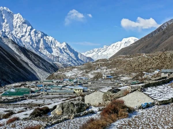
Day 7: Surke to Namche Bazaar (3,440m). The trail joins the Lukla route at Cheplung. From here, you walk the same trail as the Lukla trekkers, through Phakding, across the suspension bridges, and up the steep climb to Namche. But you arrive at Namche differently. The Lukla trekker arrives with two days of walking and zero acclimatisation. You arrive with seven days of walking, a body that has crossed passes above 3,500 metres, and lungs that have been adapting for a week. Namche feels easy. The altitude that makes others headachy makes you comfortable. Walking: six to seven hours.
What Happens From Namche to Everest Base Camp?
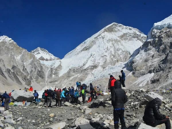
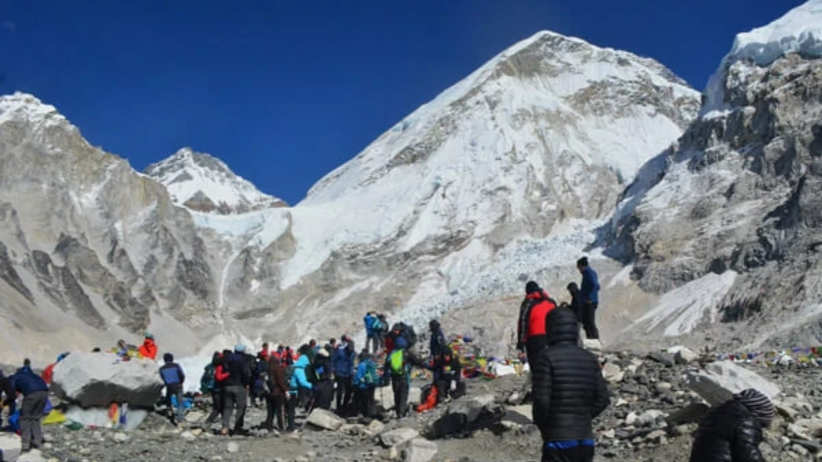
From Namche onward, the Jiri route and the Lukla route are identical. The same trail. The same teahouses. The same views. Tengboche, Dingboche, Lobuche, Gorak Shep, Everest Base Camp, Kala Patthar. The difference is how you feel walking it. The extended acclimatisation of the Jiri approach means that the altitude above Namche, which challenges Lukla trekkers, feels more manageable. Not easy. The altitude above 4,500 metres is never easy. But the foundation is stronger. The body is more prepared. The headaches are milder. The sleep is slightly better. The summit day at Kala Patthar is slightly less of a battle.
This is the Jiri route's most practical gift. Not the scenery (though the scenery is exceptional). Not the history (though the history is profound). But the physiological advantage of arriving at Namche with a week of adaptation rather than two days. The advantage compounds as the altitude increases, and by the time you reach Gorak Shep at 5,164 metres, it is the difference between surviving the altitude and thriving in it.
The Return
Most Jiri trekkers walk back to Lukla and fly to Kathmandu rather than retracing the entire Jiri route. This reduces the total trek to eighteen to twenty days rather than the twenty-four to twenty-six days required for a full Jiri-to-Jiri return. Some purists walk the entire route both ways. Some take the bus from Salleri (a town below Lukla accessible by road) rather than flying from Lukla. The logistics are flexible, your trekking company can arrange whichever combination suits your time and budget.
Who Is the Jiri to Everest Route For?
Trekkers who have time. The Jiri route adds five to seven days to the standard EBC itinerary. If you have three weeks rather than two, the Jiri approach transforms the EBC trek from a demanding mountain walk into a full walk through Nepal's hill country and the Khumbu.
Trekkers who have done EBC before. Many repeat EBC trekkers choose the Jiri approach the second time, having seen the Lukla-to-EBC route, they want to see what came before it. The Jiri section provides a completely different experience, lower altitudes, different cultures, different vegetation, different pace, that complements the Khumbu perfectly.
Trekkers who are concerned about altitude. If altitude sickness is a genuine worry, because of previous experience, medical history, or simply anxiety, the Jiri route is the safest approach to EBC. The gradual altitude gain over seven days before reaching Namche is the most conservative acclimatisation profile available for the Khumbu.
Trekkers who want solitude. The Jiri-to-Lukla section is one of the quietest trekking routes in Nepal's popular regions. During peak season, when the Lukla-to-EBC trail hosts hundreds of trekkers per day, the Jiri route hosts dozens. The difference in atmosphere is dramatic.
Trekkers who care about history. There is no other trek in Nepal where you can walk exactly the same route that the first Everest summiteers walked. The trail, the passes, the villages, and the views are unchanged since 1953. The accommodation is better. The trail is better maintained. But the geography, which is what matters, is identical.
What Do You Need to Know About the Jiri Route?
Duration: 18-20 days (Jiri to EBC to Lukla). 24-26 days for full Jiri return.
Difficulty: Moderate for the Jiri-to-Namche section (multiple passes above 3,000m but nothing above 3,530m). Challenging for the Namche-to-EBC section (same as standard EBC trek).
Maximum altitude: 5,545 metres (Kala Patthar), same as standard EBC trek.
Permits: Sagarmatha National Park entry, TIMS card, same as standard EBC trek. No additional permits for the Jiri approach.
Accommodation: teahouses throughout. The Jiri-to-Lukla section has simpler teahouses than the Lukla-to-EBC section, more basic rooms, simpler menus, fewer amenities. This is part of the charm and part of the challenge.
Cost: slightly more than the standard EBC trek due to longer duration (more days of accommodation and meals, longer guide/porter engagement). The savings from not flying to Lukla partially offset the additional days. Expect approximately two hundred to four hundred dollars more than a standard EBC package of the same quality tier.
Best season: October-November (autumn) and March-May (spring), same as standard EBC. The Jiri section is lower in altitude, so it can be warmer and more humid in the early days. Spring on the Jiri route brings rhododendron blooms at the Lamjura pass that are among the most spectacular in Nepal.
Why Is the Jiri Route Called the Walk That Earns the Mountain?
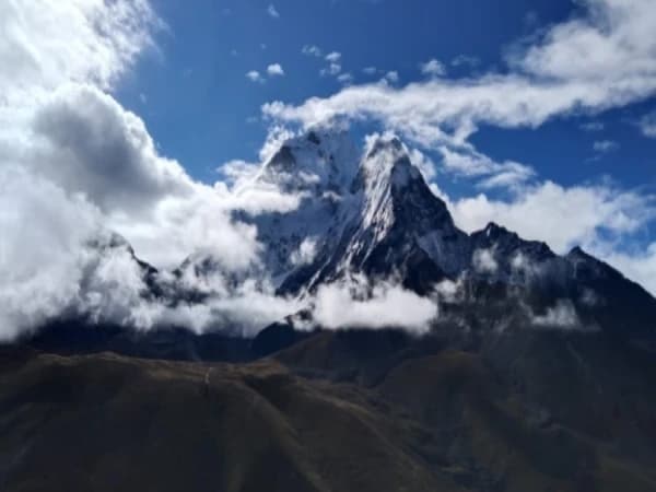
Here is what the Jiri route gives you that Lukla cannot: the approach. Not the approach in the logistical sense, getting from A to B, but the approach in the experiential sense. The slow revelation. The way Everest appears first as a distant white point above a ridge near Junbesi, then disappears for days behind nearer hills, then reappears larger and closer from the trail above Namche, then grows and grows through Tengboche and Dingboche and Lobuche until it fills the sky at Gorak Shep.
The Lukla trekker sees Everest for the first time above Namche. The Jiri walker has been watching it grow for a week. The difference is the difference between meeting someone at a party and watching them walk toward you across a field. The party introduction is immediate and exciting. The field crossing gives you time, time to prepare, time to anticipate, time to understand the scale of what is approaching.
The 1953 expedition walked for two weeks through these hills before they even began the work of climbing. Two weeks of walking, carrying, thinking, watching the mountain grow. When they finally reached base camp, they had earned the right to be there in a way that a forty-minute flight cannot replicate. The mountain had revealed itself gradually, and the revelation was part of the achievement.
The Jiri route offers that same revelation. Compressed from two weeks to one, updated with teahouses and trail markers, but fundamentally the same experience: walking toward Everest through the country that surrounds it, watching it grow from a distant point to an overwhelming presence, and arriving at its base with the specific, physical, non-negotiable knowledge that you walked here. Every step. Every pass. Every river crossing. From Jiri to Base Camp, the way it was always done before the airstrip changed everything.
The mountain does not care how you arrived. But you will. And the trekker who walked from Jiri knows something about Everest, its scale, its context, its place in the landscape of eastern Nepal, that the trekker who flew to Lukla may never fully understand. The walking is the understanding. The approach is the achievement. And the mountain, when you finally stand at its base, is not just tall. It is the culmination of everything you walked through to reach it.
Walk the original Everest route on our Jiri to Everest Base Camp Trek (18 days).
The Jiri to Everest route is the trek that Hillary and Tenzing walked. Before Lukla airport existed, this was the only way to Everest. It takes ten days longer than flying, but those ten days pass through some of the most beautiful middle-hill country in Nepal. Villages, terraces, suspension bridges, forests — and almost nobody on the trail. If you have the time, this is the real Everest experience.
We offer the classic EBC trek and can customise a Jiri start. Ask us for a quote.
WhatsApp:+977 9810351300
Email:[email protected]
Written by Shreejan Simkhada, CEO of The Everest Holiday and third-generation Himalayan guide. TAAN Member #1586.
Walking the original Hillary route? Our Jiri to Everest Base Camp Trek (18 Days) is private (your group only, no strangers), 2026 dates open, From USD $1599. WhatsApp us for tailored 2026 dates and current departures.