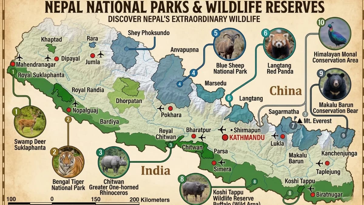
Nepal has protected twelve percent of its landmass in national parks and conservation areas—a figure that sounds modest until you consider that this twelve percent contains eight of the world's fourteen highest mountains, the birthplace of the Buddha, the deepest gorge on earth, populations of Bengal tigers and one-horned rhinoceroses, and the trails that bring half a million trekkers to the Himalayas every year. The protected areas are not separate from the trek itself. They are the trek itself. Every major trek in Nepal passes through a national park or conservation area, and the permits you carry in your pocket are not bureaucratic formalities but contributions to a conservation system that keeps the mountains, the forests, and the wildlife intact for the people who live among them and the visitors who come to see them.
Understanding Nepal's protected areas—what they protect, why they matter, and how your permit money is spent—adds a dimension to any trek that the mountain views alone cannot provide.
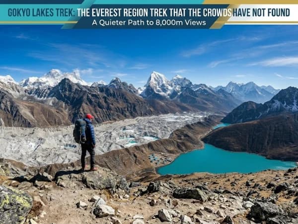
Sagarmatha National Park—The Everest Region
Established: 1976. UNESCO World Heritage Site since 1979. Area: 1,148 square kilometres. Altitude range: 2,845m (Namche Bazaar) to 8,849m (summit of Everest).
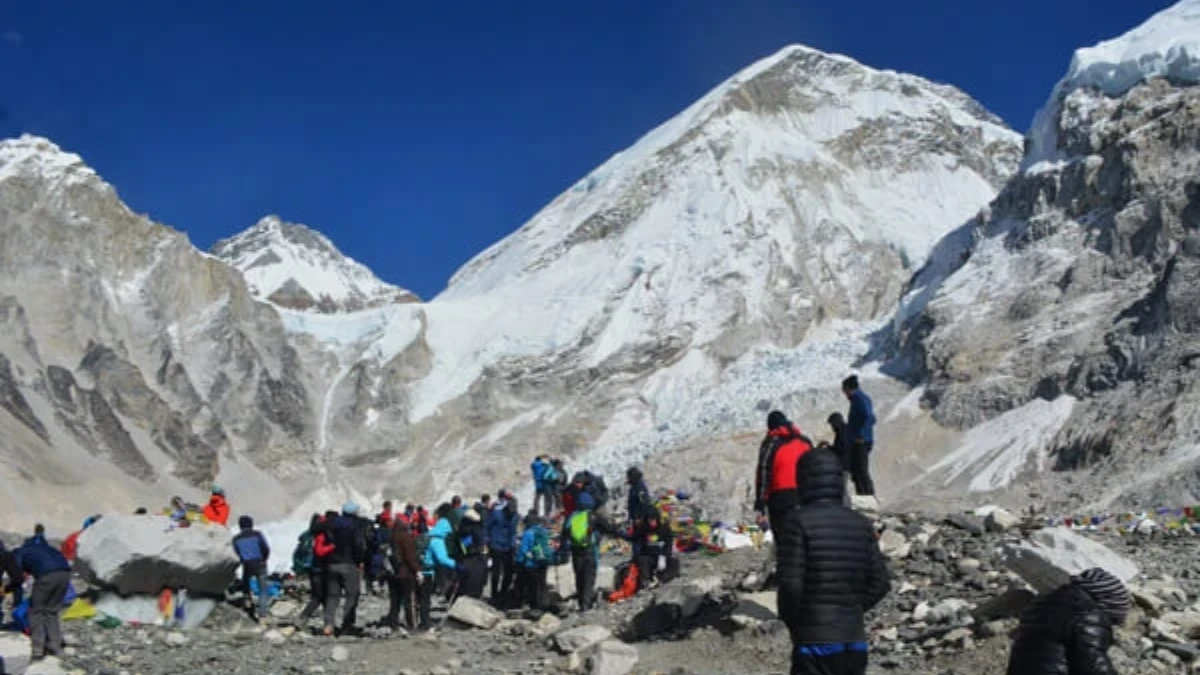
Sagarmatha is the Nepali name for Everest, and the park that bears its name protects the entire Khumbu region—every step of the Everest Base Camp trek from the park entrance at Monjo to the glaciers at the mountain's base. The park contains three of the world's highest peaks (Everest, Lhotse, and Cho Oyu), the Khumbu Glacier, the Sherpa villages of Namche Bazaar, Tengboche, and Pangboche, and forests of Himalayan birch and rhododendron that support populations of Himalayan tahr, musk deer, red panda, and the elusive snow leopard.
The park is managed with the dual mandate of conservation and cultural preservation, the Sherpa communities within the park are not relocated but integrated into the management plan, maintaining their traditional land use, their monasteries, and their relationship with the landscape that has defined Sherpa culture for centuries.
Permit: approximately sixty-eight US dollars for foreign nationals. Checked at the Monjo checkpoint alongside your TIMS card and guide credentials. The permit fee funds park management, trail maintenance, waste management programmes, and the ranger stations that monitor wildlife and enforce regulations.
Treks: Everest Base Camp, Gokyo Lakes, Island Peak, Cho La crossing, and Three Passes trek.
What is the most visited protected area in Nepal?
Established: 1986. Area: 7,629 square kilometres, the largest conservation area in Nepal. Altitude range: 790m to 8,091m (Annapurna I summit).
The Annapurna Conservation Area Project (ACAP) protects the entire Annapurna region, the Circuit, ABC, Ghorepani-Poon Hill, the Nar-Phu Valley, and the approach to Upper Mustang. It is the most visited protected area in Nepal, receiving over one hundred thousand trekkers per year, and its management model, community-based conservation that integrates local communities into decision-making and revenue sharing, has been internationally recognised as a success.
The ACAP model works because it treats local communities as partners rather than obstacles. A portion of the permit revenue goes directly to village development committees, funding schools, health posts, trail maintenance, and alternative energy projects (solar panels, micro-hydro) that reduce the pressure on forests. The result is a conservation area where the people who live inside the boundary benefit directly from its protected status, aligning economic incentives with conservation goals.
The area protects extraordinary biodiversity, over 1,226 plant species, 102 mammals, 474 birds, 39 reptiles, and 22 amphibians. The Annapurna range itself is home to snow leopards, Himalayan tahr, blue sheep, and the endangered red panda. The lower forests contain langur monkeys, barking deer, and an avian diversity that makes the Annapurna region one of the best birding destinations in Asia.
Permit: approximately thirty-four US dollars (ACAP permit). Checked at entry points and along the trail. Treks: Annapurna Circuit, ABC, Ghorepani-Poon Hill, Nar-Phu Valley, Khopra Ridge, approach to Upper Mustang.
Which national park is closest to Kathmandu?
Established: 1976. Area: 1,710 square kilometres. Altitude range: 792m to 7,245m (Langtang Lirung).
Langtang is the most accessible Himalayan national park, the trailhead at Syabrubesi is a seven-to-eight-hour drive from Kathmandu, making it possible to be walking in a national park within a day of arriving in Nepal. The park protects the Langtang Valley, the Helambu region, and the Gosaikunda sacred lakes, three distinct trekking areas within a single park boundary.
The 2015 earthquake devastated parts of Langtang National Park. The earthquake triggered an avalanche that buried the village of Langtang, killing over 300 people, including trekkers and locals. The village has been rebuilt nearby, and the trail is fully open, but the memorial at the avalanche site is a sobering reminder of the forces that shape the landscape through which you walk.
The park's forests are among the best-preserved in the Kathmandu region, oak, rhododendron, and bamboo at lower altitudes, giving way to birch and juniper at higher altitudes. Red pandas inhabit the bamboo forests (the park is one of the better locations in Nepal for a sighting, though they remain extremely elusive). Himalayan black bears, langur monkeys, and musk deer are also present.
Permit: approximately thirty-four to sixty-eight US dollars, depending on nationality. Treks: Langtang Valley, Gosaikunda, Helambu, and Tamang Heritage Trail.
Do you need a special permit for the Manaslu Circuit?
Established: 1998. Area: 1,663 square kilometres. Altitude range: 600m to 8,163m (Manaslu summit).
The Manaslu Conservation Area is a restricted area, entry requires a special permit (one hundred US dollars per week in peak season) and a minimum group of two trekkers with a licensed guide. These restrictions have preserved the area's character in a way that the Annapurna region's open-access policy has not. The Manaslu Circuit receives a fraction of the Annapurna Circuit's visitors, and the trail retains the remote, uncommercialized character that the Annapurna Circuit had before road construction changed its lower sections.
The conservation area protects the Budhi Gandaki and Marsyangdi watersheds, including dense subtropical forests, alpine meadows, and glacial terrain around the base of Manaslu. The biodiversity is exceptional, thirty-three mammal species, including snow leopard, Himalayan tahr, and musk deer, and over one hundred and ten bird species.
The Tsum Valley, a sacred Buddhist valley within the conservation area, was closed to foreigners until 2008 and is now accessible under the Manaslu restricted area permit, adding a cultural dimension that few other trekking areas can match.
Permit: restricted area permit (one hundred dollars per week in peak season, seventy-five in other months) plus MCAP conservation area permit. Treks: Manaslu Circuit, Tsum Valley.
What wildlife can you see in Chitwan National Park?
Established: 1973 (Nepal's first national park). UNESCO World Heritage Site since 1984. Area: 952 square kilometres. Altitude: 100-815m.
Chitwan occupies a different ecological zone from the mountain parks, the subtropical Terai lowlands of southern Nepal, where sal forest, grassland, and riverine habitat support some of Asia's most important wildlife populations. Bengal tigers (over one hundred and twenty individuals), greater one-horned rhinoceroses (over six hundred), Asian elephants, gharial and mugger crocodiles, sloth bears, and over five hundred bird species make Chitwan one of the premier wildlife destinations in South Asia.
Chitwan is not a trekking destination but a safari destination, visitors explore by jeep, canoe, and guided walking safari. The park is commonly combined with a Himalayan trek as a pre- or post-trek experience, providing the contrast between mountain and jungle that makes a Nepal trip complete.
The park's conservation success, particularly the recovery of the tiger and rhino populations from near-extinction in the 1970s, is one of Nepal's great environmental achievements and a model for wildlife conservation in developing countries.
Permit: approximately fifteen to twenty-five US dollars per day. Access from Kathmandu (five to six hours by tourist bus) or Pokhara (four to five hours).
Is Bardia or Chitwan better for a wildlife safari?
Established: 1988. Area: 968 square kilometres. Altitude: 100-1,438m.
Bardia is Chitwan's wilder, remoter western counterpart. Twice the size of Chitwan in terms of the total protected area (including buffer zones), with half the visitors. The park protects the Karnali River floodplain, dense sal forest and grassland that supports the same megafauna as Chitwan (tigers, rhinos, elephants) plus wild elephants (not domesticated), Gangetic river dolphins, and one of the highest tiger densities in the subcontinent.
Bardia's remoteness, a domestic flight to Nepalgunj plus a two-and-a-half-hour drive, keeps visitor numbers low and the wildlife trip genuinely wild. Jungle walks with experienced naturalist guides are the signature activity, offering close encounters with the forest that vehicle-based safaris cannot replicate.
Permit: approximately fifteen to twenty-five US dollars per day. Access from Kathmandu via Nepalgunj (flight plus drive) or overland (twelve to fourteen hours).
What is Makalu-Barun National Park known for?
Established: 1992. Area: 1,500 square kilometres (park) plus 830 square kilometres (buffer zone). Altitude range: 435m to 8,485m (Makalu summit).
Makalu-Barun is the only protected area in Nepal where no permanent human settlements exist within the park boundary. The result is a genuinely untouched wilderness, old-growth forest, undisturbed alpine meadows, and glacial landscapes that have not been altered by human activity. The park protects the approaches to Makalu, the world's fifth-highest mountain, and contains the Barun Valley, considered one of the last untouched Himalayan ecosystems.
The park's biodiversity reflects its undisturbed status, red pandas, clouded leopards, Himalayan black bears, wild dogs (dholes), and an extraordinary diversity of orchids, rhododendrons, and alpine plants. The birding is exceptional, with species found nowhere else in Nepal's protected areas.
Treks: Makalu Base Camp (fourteen to twenty-one days, requiring a special permit and self-sufficiency for camping sections).
Kanchenjunga Conservation Area, The Far Northeast
Established: 1997. Area: 2,035 square kilometres. Altitude range: 1,200m to 8,586m (Kanchenjunga summit).
Nepal's far northeastern corner shares the border with India's Sikkim state. Kanchenjunga (the world's third-highest mountain) dominates the conservation area, which protects some of the most remote and biodiverse terrain in Nepal. The treks to the Kanchenjunga base camp, north and south, receive fewer than two thousand trekkers per year and offer a wilderness experience that rivals Dolpo for remoteness.
The conservation area is managed by local communities under a model similar to ACAP, with permit revenue funding village development and conservation programmes.
Permit: restricted area permit required plus conservation area fee. Minimum group of two trekkers with a licensed guide.
What is the largest national park in Nepal?
Established: 1984. Area: 3,555 square kilometres, the largest national park in Nepal. Altitude range: 2,000m to 6,883m.
Shey Phoksundo protects the Dolpo region of western Nepal, the most remote and least visited major trekking area in the country. Phoksundo Lake, the deepest lake in Nepal (145 metres), sits within the park at 3,611 metres, a turquoise jewel in a landscape of desert canyons and Buddhist monasteries. Peter Matthiessen's "The Snow Leopard" (1978) made Dolpo famous; the park protects the habitat of the snow leopard, blue sheep, and the culture of the Dolpo-pa people who have lived here for centuries.
Lower Dolpo (accessible with a national park permit) includes Phoksundo Lake and is reachable in a trek of seven to ten days. Upper Dolpo (requiring a restricted area permit of fifty US dollars per day) extends into the trans-Himalayan desert and is one of the ultimate trekking experiences in Nepal, remote, culturally unique, and extraordinarily beautiful.
Why do trekkers need national park permits in Nepal?
The permit fee you pay, thirty-four dollars for ACAP, sixty-eight dollars for Sagarmatha, and one hundred dollars per week for Manaslu, is not a tax on tourism. It is an investment in the landscape you are walking through. The money funds ranger salaries (the people who monitor wildlife, enforce regulations, and assist trekkers in emergencies), trail maintenance (the stone steps, the bridges, and the signage that make trekking possible), waste management (the cleanup campaigns, the rubbish collection points, and the incinerators that handle the waste that hundreds of thousands of trekkers generate), and community development (schools, health posts, and alternative energy systems that reduce pressure on forests).
The system is imperfect. Not all permit revenue reaches its intended destination efficiently. Corruption exists. Some parks are better managed than others. But the fundamental framework, that the people who enjoy the parks pay for their maintenance and that the communities who live within the parks benefit from their protected status, is sound, and the alternative (unprotected land, unmanaged trails, uncontrolled development) is visible in the areas of Nepal that lack park or conservation area status.
When you hand your permit to the ranger at the park entrance, you are not completing a bureaucratic requirement. You are participating in the system that keeps the mountains, the forests, the wildlife, and the communities intact. The trail you walk tomorrow was maintained by the money collected at the checkpoint today. The forest you walk through was protected by the regulations your permit enforces. And the wildlife you hope to see, the tahr on the ridge, the monal in the rhododendron, the snow leopard that watches from the rocks and chooses not to be seen, survives because someone drew a line on a map and said: this territory is protected." This is a national park. This matters.
It does matter. And the twelve percent of Nepal that is protected, the twelve percent that contains the highest mountains, the deepest gorge, the rarest wildlife, and the trails that bring the world to Nepal, matters more than its area suggests. It is the twelve percent that defines Nepal. And every trekker who walks through it, permit in pocket, contributes to its continuation.
Our treks pass through some of Nepal's finest national parks. See all treks for routes through Sagarmatha, Langtang, Annapurna Conservation Area, and more.
Nepal has twenty national parks and conservation areas, and most visitors only see Chitwan. That is like going to a library and reading one book. Sagarmatha protects Everest. Langtang protects the valley that the earthquake nearly destroyed. Bardia protects tigers that the rest of Nepal almost lost. Each park tells a different story about what Nepal is trying to save.
Many of our treks pass through these protected areas. If you want help choosing which one to visit, just ask.
WhatsApp:+977 9810351300
Email:[email protected]
Written by Shreejan Simkhada, CEO of The Everest Holiday and third-generation Himalayan guide. TAAN Member #1586.
Touring Nepal's national parks? Our Kathmandu, Pokhara, Chitwan Tour (8 Days) is private (your group only, no strangers), 2026 dates open, From USD $699. WhatsApp us for tailored 2026 dates and current departures.