
The Gokyo Lakes trek takes ten days on our itinerary, tops out at 5,357 metres on Gokyo Ri, and is graded Strenuous. It follows the Everest Base Camp trail as far as Namche Bazaar, then turns north-west up the Dudh Koshi valley to a chain of glacial lakes beside the Ngozumpa Glacier. There is no pass to cross, and no technical climbing. The difficulty is altitude and long days at 4,000 metres and above, not rock or ice. This page gives you the day-by-day plan, the sleeping heights, where the trek really gets hard, and when to go.
How long is the Gokyo Lakes trek, and how hard is it?
Our Gokyo Valley Lakes trek is ten days from Kathmandu to Kathmandu, with eight walking days and one rest day in Namche. On the package figures the walking adds up to about 71 kilometres. The longest days are six to seven hours, and four of the nights are spent at 4,110 metres or higher. On our own grading it sits in the same band as Everest Base Camp: Strenuous, which for us means long, demanding days at high altitude and good fitness.
The route is a walk, not a climb. You sleep in teahouses, a guide goes with you every step, and you do not cross a high pass. What makes it hard is the same thing that makes Everest Base Camp hard. You go from 2,860 metres at Lukla to 4,790 metres at Gokyo in six days, and then you go up to 5,357 metres in a single day. If you want the comparison, the Centers for Disease Control and Prevention says that at the higher elevations along standard Everest routes the prevalence of altitude illness can approach 30 per cent. That is a figure for trekkers in general, not for our groups, and it is the reason this page spends so long on the altitude.
What is the day-by-day itinerary for the Gokyo Lakes trek?
This is the itinerary on our live package page. The last column is my own subtraction of one night's sleeping height from the next, using the package's altitudes.
| Day | From and to | Sleep at | Walking time | Distance | Change in sleeping height |
|---|---|---|---|---|---|
| 1 | Fly Kathmandu or Manthali to Lukla (2,860 m), walk to Phakding | Phakding, 2,610 m | About 3 hours after a 20 to 40 minute flight | 6.2 km | Down 250 m from Lukla |
| 2 | Phakding to Namche Bazaar | Namche, 3,440 m | 5 to 6 hours | 7.4 km | Up 830 m |
| 3 | Rest and acclimatisation day | Namche, 3,440 m | Short walk only | None | None |
| 4 | Namche Bazaar to Dole | Dole, 4,110 m | 5 to 6 hours | 11 km | Up 670 m |
| 5 | Dole to Machhermo | Machhermo, 4,470 m | 5 to 6 hours | 7 km | Up 360 m |
| 6 | Machhermo to Gokyo | Gokyo, 4,790 m | 4 to 5 hours | 5.7 km | Up 320 m |
| 7 | Gokyo Ri (5,357 m), then down to Machhermo | Machhermo, 4,470 m | 6 to 7 hours | 11 km | Down 320 m |
| 8 | Machhermo to Namche Bazaar | Namche, 3,440 m | 5 to 6 hours | 9.6 km | Down 1,030 m |
| 9 | Namche Bazaar to Lukla | Lukla, 2,860 m | 6 to 7 hours | 13.5 km | Down 580 m |
| 10 | Fly Lukla to Kathmandu or Manthali | Kathmandu | 20 to 40 minute flight | None | None |
Days 1 to 3 are the Everest Base Camp approach, and our Everest Base Camp itinerary, day by day describes them in more detail. The paths part on day 4. Instead of climbing towards Tengboche you head up the valley to Dole. Our Dole guide describes that day in full: you climb to the Mong La ridge, drop hard to the river, and climb again through forest until the trees stop. Day 5 follows the Dudh Koshi to Machhermo, which has its own page in our Machhermo guide. Day 6 takes you to Gokyo, and the Gokyo village guide covers what the village is like. Gokyo village is 4,790 metres on our itinerary. Some sources give 4,750, so you may see that figure elsewhere.
Where does the Gokyo Lakes trek get hard, and how do you handle the altitude?
There are three places, and they are not the ones people expect.
Day 4, Namche to Dole. The climb is 670 metres in sleeping height. The CDC Yellow Book says that above 3,000 metres a traveller should limit the gain in sleeping altitude to no more than 500 metres a night, and should allow an extra night for every 1,000 metres gained. Dole is above that figure. The day is also physically hard, with a big descent in the middle that you have to climb back out of. I will not pretend the 10-day plan is gentle here. It has one rest day, at Namche, and it relies on that day and on a fit group. If you have never been above 3,000 metres, or you simply want margin, ask us and we will quote an extra day. Do not squeeze this itinerary into fewer days than it has.
Day 7, Gokyo Ri. This is the highest point of the trek and the longest day. The ascent is 2 to 3 hours from the village. After the summit you walk all the way down to Machhermo, so the day is six to seven hours in total. You wake at 4,790 metres, which is already high, and you climb 567 metres more. Go slowly, drink water and eat even if you do not want to.
Days 8 and 9, the way out. Machhermo to Namche is a descent of 1,030 metres, and Namche to Lukla is a long final day. Nothing about the altitude is hard here, but knees and tired legs are. Trekking poles help, and a short training programme with stairs and downhill walking helps more than people expect.
What we do about altitude is simple. Your guide watches you, and he checks you with a pulse oximeter. He can turn you around, or turn the group around, if you are not well. The CDC says a descent of 300 metres or more quickly improves altitude sickness,. If you feel a headache with nausea, dizziness, or unusual tiredness, tell your guide at once rather than waiting for the next teahouse. Confusion, clumsiness walking in a straight line, or breathlessness at rest are signs of a medical emergency, and the answer is to go down. Our full guide to altitude sickness on Nepal treks covers the symptoms and the medicines, our piece on acclimatisation on Nepal treks explains why rushing backfires, and what happens on an acclimatisation day shows what the rest day at Namche looks like. Whatever your plan, you need travel insurance that covers helicopter evacuation at altitude, and I do not recommend buying it in Nepal.
What do you see from Gokyo Ri and at the lakes?
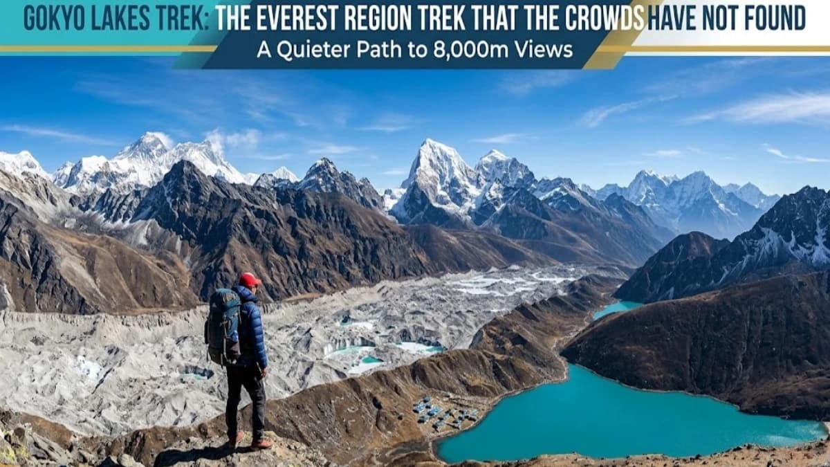
Gokyo Ri is 5,357 metres (17,575 feet), on the western side of the Ngozumpa Glacier. You can see four of the world's mountains above 8,000 metres from the summit: Mount Everest, Lhotse, Makalu and Cho Oyu. The Ngozumpa Glacier is 36 kilometres long, and it is the longest glacier in Nepal. The hill is a steep, long walking climb on a fairly popular trekking route. It is a different view from Kala Patthar, the viewpoint on the Base Camp route. Kala Patthar is higher at 5,545 metres on our 15-day itinerary, and it puts Everest much nearer. Gokyo Ri gives you the lakes and the glacier in the foreground. I would not call one better. They are different, and which you prefer is a matter of taste.
The lakes themselves are listed as a wetland of international importance. The Gokyo lake system holds 19 lakes between 4,710 and 4,950 metres, and Gokyo and its wetlands, 7,770 hectares in all, became a Ramsar site in September 2007. Trekkers usually talk about a chain of five or six main lakes beside the glacier, and different pages count them differently, so don't take any single number as final. The water colour changes with the light, the season and the sky, so don't expect a particular shade on the day you arrive. The views and the lakes depend on cloud as much as on anything we can plan.
When is the best time to do the Gokyo Lakes trek, month by month?
The Gokyo valley follows the same seasons as the Everest Base Camp trail, because it shares the Lukla flight and the first three days. The only measured weather table is for Namche Bazaar, at about 3,450 metres, from the Food and Agriculture Organization of the United Nations. Gokyo is about 1,350 metres higher than Namche, so it is colder, especially at night. There is no measured series for Gokyo. Read the Namche figures as the milder end of what you will meet.
| Month | Namche average daily high and low | Namche rain | What it means for Gokyo |
|---|---|---|---|
| January and February | 6.9 and minus 8.5 degrees in January, 6.4 and minus 6.5 in February | 43 mm and 20 mm | Clear and very cold. Some high lodges close and the trail is nearly empty. For people who accept the cold. |
| March | 9.6 and minus 3.0 | 31 mm | Cold early, warming later. The spring flight window opens around 15 March. |
| April | 12.8 and 0.8 | 26 mm | Warmer days and strong views. A busy month on the main trail. |
| May | 14.3 and 3.7 | 39 mm | The warmest trekking month, with hazier afternoons as the monsoon approaches. The spring window ends around 15 May. |
| June to September | 14.6 to 16.2 highs | 129 to 226 mm in June to August, 140 mm in September | Monsoon. Cloud, rain and flight disruption. We do not recommend it for Gokyo. |
| October | 12.5 and 1.2 | 57 mm | The most reliable month and the busiest. The autumn window runs from about 25 September. |
| November | 9.1 and minus 3.8 | 11 mm | Clear and crisp, with colder nights. Quieter later in the month. The autumn window ends around 30 November. |
| December | 7.6 and minus 7.1 | 24 mm | Cold and clear. For experienced trekkers only on this route, and we will talk it through first. |
The month-by-month advice for the whole Khumbu is in our best time to trek the Everest region and Everest weather month by month guides, and both apply to Gokyo. October is the safest bet and the busiest, and November gets clearer and quieter as it goes on. Dates in a given year move, so if you tell me your window I will say what I know about that week.
How do you get to Lukla, and what if the flight is cut?
Lukla is at 2,860 metres. In the busy windows, which are roughly 15 March to 15 May and 25 September to 30 November by our working dates, most Lukla flights leave from Manthali in Ramechhap district, not from Kathmandu. That means a pick-up from your Kathmandu hotel between midnight and 2 am, a drive of four to five hours, and a flight of about 20 minutes. Our Manthali airport guide describes the whole night, and our domestic flights guide has the baggage rules and the delay policy.
Weather holds at Lukla are routine, so leave a spare day at the end of the trek, and do not book a tight flight home. If you would rather avoid Manthali, the helicopter flies direct from Kathmandu. As a guide, our flights guide gives a shared seat at about USD 640 per person from Kathmandu to Lukla and about USD 710 per person from Lukla to Kathmandu, including government tax, bank charges and the fuel supplement. Shared seats depend on availability and weather. A helicopter from Gokyo itself is on request, with no fixed price, and I will not guess one. On our Luxury tier the helicopter to and from Lukla is included, and Budget and Standard fly fixed-wing both ways.
Is the Gokyo Lakes trek better than Everest Base Camp?
It depends on what you want, and I would rather give you the trade-offs than a verdict.
- Base Camp itself. On the 10-day Gokyo trek you do not reach Everest Base Camp. If standing at 5,364 metres at Base Camp itself is the point of your trip, book the Everest Base Camp trek.
- Views. Gokyo gives you lakes, a glacier and four giants from one summit. Base Camp gives you the place itself and Kala Patthar at 5,545 metres.
- Altitude. They are comparable. Gokyo Ri is 5,357 metres against 5,545 at Kala Patthar. But on the Gokyo plan you sleep at 4,470, 4,790 and then 4,470 metres again over three nights, which is a lot of time high.
- Crowds. Gokyo is quieter. About 7,000 tourists a year visit the Gokyo Lakes, though the count carries no date. Our guides put the valley at roughly a fifth of the traffic on the main Base Camp corridor. That is our estimate from the trail, not a count.
- Cost and days. It is shorter and therefore cheaper in total, and our Gokyo Lakes trek cost guide works out what you pay on each tier.
Our longer comparison is Everest Base Camp versus Gokyo Lakes.
Can you combine Gokyo with Everest Base Camp, or cross Cho La?
Yes, in two ways, both of them longer. Our Everest Base Camp with Gokyo Ri trek is 15 days. It goes up the main trail to Base Camp and Kala Patthar, then down to Pheriche and Phortse, across to Machhermo, and on to Gokyo and Gokyo Ri, before coming out through Dole and Namche. It crosses no pass. The other route crosses Cho La, and our Everest Base Camp, Gokyo Lakes and Cho La Pass trek is the package for it.
Cho La is 5,420 metres and links Thagnak in the Gokyo side with Dzongla on the Base Camp side. It is covered in snow for nine months of the year, crampons may be needed on the icy ground, and the edge of the glacier is unstable. It is physically demanding and depends on good weather on the day. Our Cho La Pass guide and our Thangnak guide cover it, and for the bigger loop with Renjo La as well, see the Everest Three Passes trek and its cost guide. My honest advice is to do Gokyo first if you are unsure. You can add Cho La on a later trip.
What do the permits and cost look like?
The Gokyo valley is inside Sagarmatha National Park, so the permits are the same as for Base Camp: the park entry fee of NPR 3,000, the Khumbu Pasang Lhamu Rural Municipality fee of NPR 3,000, and a TIMS card at NPR 2,000. That is NPR 8,000 per person. We buy the TIMS card through our agency for every trekker, and the permits are included in the price on every tier of our package. Our permits and fees guide explains who buys what, and the cost guide has the prices, the three tiers and what is and is not included.
The tiers differ in who carries your bag, what you eat and where you sleep, not in the route. Budget has no porter, Standard has one porter for every two trekkers, and Luxury has a dedicated porter for each trekker. A Kathmandu hotel is not included in any trek tier, and we quote it separately. We always trek with a licensed guide.
Who should not book the Gokyo Lakes trek?
Skip this trek, or talk to me first, if any of these is true:
- You cannot walk six to seven hours on consecutive days at 4,000 metres and above, with a rest day only at Namche.
- You want to stand at Everest Base Camp itself. Take the Base Camp trek, or the 15-day combination.
- You have had altitude sickness before, or you have a heart or lung condition. See a doctor first, and tell us before you book.
- You are trekking in the monsoon and expect clear lake views. You will probably not get them.
- You want a luxury lodge at every stop. The teahouses at Dole and Machhermo are small and simple, and Gokyo is a handful of lodges.
It is a good trek for people who want the Khumbu with fewer people, who like water and glacier scenery, and who are fit enough to enjoy the long days. If that is you, it is one of the best things in the Everest region.
The short version
The Gokyo Lakes trek is 10 days, Strenuous, and tops out at 5,357 metres on Gokyo Ri. The hard parts are the 670-metre climb from Namche to Dole, the long Gokyo Ri day, and the way out. The best months are October, November and April. Expect a midnight to 2 am pick-up if your flight leaves from Manthali, and keep a spare day at the end. If you want a slower schedule, ask for the extra day. To talk through your dates, message me on WhatsApp on +977 9810351300. For the route, read our Gokyo village guide, and for what it costs, our Gokyo Lakes trek cost guide.
Sources
Sources: Nepal Tourism Board (TIMS and national park fees), CDC Yellow Book (high-altitude travel and altitude illness), and our own live package pages, permit table and flights guide.
WhatsApp: +977 9810351300
Email: [email protected]
Written by Shreejan Simkhada, CEO of The Everest Holiday and third-generation family guide. TAAN Member #1586.
 Chat with Shreejan