
Short answer: Kothe is a small village at about 3,600 m on the Hinku Khola, the first night on the floor of the Hinku valley on the way to Mera Peak (6,476 m). From here the trail climbs slowly through Thaknak (about 4,350 m) to Khare (about 5,045 m), the staging village below the mountain. Take it slowly from here. You stay at Kothe on our Mera Peak climb.
Every trek has a place where the map stops being a list of names and turns into a real journey, and on the way to Mera Peak that place is Kothe. It is the first proper night down on the floor of the Hinku valley, a small riverside village where the forest closes in, the river runs loud, and the mountain you have come all this way to climb finally shows itself above the trees. Most people pass through it twice and remember it fondly both times.
Where is Kothe?
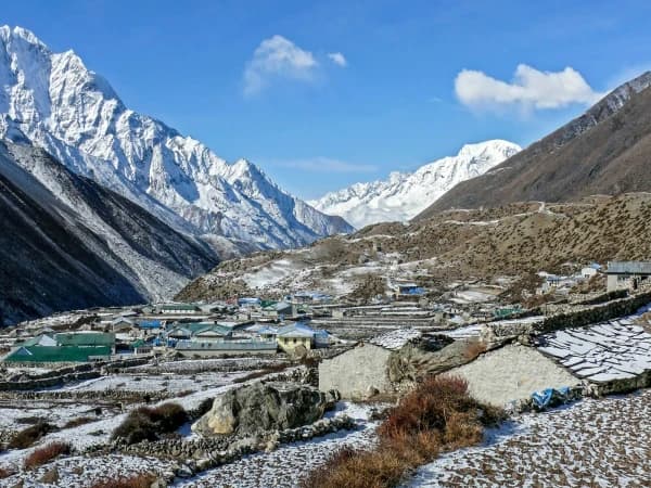
Kothe sits at about 3,600 metres (11,811 feet) in the Hinku valley, in Solukhumbu District, Koshi Province, in the far east of the Everest region of Nepal. It lies right on the Hinku Khola, the river that drains the whole valley, and the trail follows that river all the way up to the head of the valley where Mera Peak stands at 6,476 metres (21,247 feet), the highest trekking peak in Nepal. Kothe is where the southern approach we walk, the quiet line in through Paiya and Pangkongma, drops down off the ridges and joins the main valley floor. From here on there is only one way, and it is up.
It is worth knowing that this is not the busy Everest Base Camp corridor on the other side of the ridge. The Hinku is a separate valley, wilder and far less walked, and Kothe is one of the few places in it with a cluster of lodges to sleep in.
What is Kothe actually like?
Kothe is a small settlement of stone and timber teahouses strung along the Hinku Khola, sitting right around the tree line. Below and around it the valley is still forested, with blue pine, birch and rhododendron, so unlike the bare high camps further up you arrive here to the sound of the river and birds in the trees rather than to open rock and wind. It is a sunny, sheltered spot by the standards of this trek, which is exactly why it works as a stop.
The lodges are simple and built for trekkers and climbers rather than for a large resident community, so the menus are short and the comforts are basic. That is the character of the place, not a fault in it. After days of walking in from the Lukla side, a warm room, a hot meal and the quiet of the valley feel like a great deal more than they would anywhere else.
Why does the trek drop down to Kothe?
Because the Hinku valley is the road to Mera Peak, and Kothe is its gateway. On the way in, Kothe is where you leave the forested foothills behind and commit to the valley proper. From here the trail climbs steadily north through Thaknak (about 4,350 metres) to Khare (about 5,045 metres), the high staging village below the mountain, and then on to high camp and the summit. Kothe is the last place you sleep in real forest before all of that.
On the way back down it does a second, quieter job. After the summit and the high nights, descending to the warmer, richer air of Kothe is a genuine relief for the body, and it is where most people first feel properly recovered. Coming down to sleep low after climbing high is not just pleasant here, it is good mountain sense.
How does altitude work around Kothe?
At 3,600 metres Kothe is not where the serious height begins, but it is the doorway to it. The valley above rises quickly, and the single biggest thing that goes wrong on a climb like Mera is people gaining height too fast. The sensible way to walk it is to reach Kothe already acclimatising gently from the days below, then move up the valley slowly, with a proper acclimatisation day built in higher up at Khare before the mountain itself.
On our treks the guide carries a pulse oximeter and checks your oxygen up high, and the plan bends to how you are actually doing rather than to a fixed timetable. Our guides do not carry bottled oxygen as a matter of course, and on a well-paced trek you should not need it; the answer to thin air is to walk slowly and let your body keep up. If you want the full picture of how height is managed on a Nepal trek, we set it out plainly in our guide to acclimatisation on Nepal treks.
Is the Hinku valley protected?
Yes. The upper Hinku valley falls within Makalu Barun National Park, which was established in 1992 and covers 1,500 square kilometres across the Solukhumbu and Sankhuwasabha districts of Koshi Province. It is the reason the forests around Kothe are as intact as they are, and why the valley stays wild rather than developed. Walking a Mera trip means walking through protected country, with the permits that go with it, and it is part of why the Hinku feels so empty compared with the trails one ridge over.
When does the trek go through Kothe?
We walk through Kothe twice on our Mera Peak climbing trip. On the way in you reach it in the first half of the trek, coming down off the Paiya and Pangkongma approach to the valley floor, and it is your first night on the Hinku Khola. On the way out you return to Kothe after the summit, descending from Khare to sleep low again before the final walk back to Lukla. Either way its role is the same: the green, sheltered pivot between the forested approach and the high mountain.
Mera is a climbing trip as well as a trek, so the seasons that suit it are the two clear-weather windows, October and November in the autumn and roughly March to May in the spring. Those are the months when the high camps are staffed and the weather on the summit day gives you the best chance of the view, which from the top takes in five of the world's fourteen highest mountains.
The short version
Kothe is a small forested village on the Hinku Khola at about 3,600 metres, the gateway to the Mera Peak valley and the last real forest before the high country. You pass through it going up and coming down, and both times it does something useful: on the way in it marks the start of the valley proper, and on the way out it is where you finally breathe easy again. If you picture it as the quiet green hinge of the whole Mera trek, you have it about right.
Written by Shreejan Simkhada, CEO of The Everest Holiday and third-generation Himalayan guide. TAAN Member #1586.
 Chat with Shreejan