
The ranger at Monjo checks your permit, records your name in a ledger, and waves you through a stone gateway decorated with prayer flags. You have just entered Sagarmatha National Park — 1,148 square kilometres of protected Himalayan wilderness that contains the highest mountain on earth, the longest glacier in Nepal, the oldest Sherpa monasteries in the Khumbu, and an ecosystem that ranges from rhododendron forest at 2,800 metres to permanent ice at 8,849 metres. The permit in your pocket cost sixty-eight US dollars. What it buys is access to a landscape that has been protected since 1976 and recognised as a UNESCO World Heritage Site since 1979 — a landscape that belongs, in the deepest sense, not to the trekkers who walk through it but to the Sherpa communities who have lived within it for five centuries and to the wildlife that has inhabited it for millennia.
Most trekkers think of Sagarmatha National Park as the Everest Base Camp trail. It is. But it is also the Gokyo Lakes trail, the Three Passes route, the Island Peak climbing route, the Ama Dablam approach, and every side valley, high ridge, and glacial cirque in the Khumbu region. Every step you take above Monjo — every teahouse you sleep in, every bridge you cross, every mountain you photograph — is inside the park. The rules that govern the park shape your experience, even when you are not aware of them.
What the Park Protects
Mountains. Three of the world's fourteen eight-thousanders lie within or on the boundary of Sagarmatha National Park: Everest (8,849 metres), Lhotse (8,516 metres), and Cho Oyu (8,188 metres). The park also contains dozens of peaks above 6,000 metres, including Ama Dablam (6,812 metres), Pumori (7,161 metres), Nuptse (7,861 metres), and Island Peak (6,189 metres).
Glaciers. The Khumbu Glacier — the glacier you walk across to reach Everest Base Camp, is the most famous, but the park contains an extensive glacial system that includes the Ngozumpa Glacier (the longest in Nepal, visible from Gokyo Ri), the Imja Glacier, and dozens of smaller glaciers that feed the Dudh Koshi river system. These glaciers are retreating, climate change is measurably shrinking the ice, and the park's monitoring programmes track the retreat to understand its implications for water supply, glacial lake outburst floods, and the ecosystems downstream.
Forests. The lower sections of the park, between Monjo (2,800 metres) and Tengboche (3,860 metres), are covered in subalpine forest: birch, rhododendron, juniper, and fir. The rhododendron forests bloom in spring (April-May) with crimson and pink flowers that transform the trail into a tunnel of colour. Above the tree line (approximately 4,000 metres), the landscape transitions to alpine scrub, then to rock, ice, and snow.
Wildlife. The park is home to wildlife that most trekkers never see, because the animals are elusive, because the habitat is vast, and because the trail follows the valleys while the wildlife prefers the ridges.
The Himalayan tahr, a wild goat with shaggy brown fur and curved horns, is the most commonly seen large mammal. Tahr graze on the steep hillsides above Namche and Tengboche, and attentive trekkers can spot them on rocky outcrops in the early morning. Musk deer, small, solitary, and nocturnal, inhabit the forests but are rarely seen. The Himalayan black bear is present but avoids human contact entirely.

The snow leopard is the park's most famous and most elusive resident. Sagarmatha National Park is confirmed snow leopard habitat, and camera trap surveys have documented individuals at altitudes between 3,500 and 5,500 metres. Seeing a snow leopard on the EBC trail is extraordinarily unlikely, the cats are masters of camouflage and avoid human activity, but knowing they are there, watching from the ridges above the trail, adds a dimension to the landscape that the visible world does not contain.
Bird life is more accessible. The danphe, the Himalayan monal, Nepal's national bird, is a pheasant-sized bird with iridescent plumage that flashes green, blue, red, and gold in sunlight. Males display in clearings and on ridges during the breeding season (spring), and the sight of a danphe in full colour against a backdrop of snow-capped peaks is one of the trail's unexpected gifts. Other notable birds include the blood pheasant, the Tibetan snowcock, the golden eagle, and the lammergeier (bearded vulture), whose three-metre wingspan casts a shadow that makes trekkers look up.
Sherpa culture. The park is unusual among national parks in that it contains permanent human settlements. The Sherpa communities of Namche Bazaar, Tengboche, Pangboche, Dingboche, Khumjung, Khunde, Thame, and others have lived within the park boundary for centuries, and the park management plan integrates their presence rather than excluding it. The monasteries, mani walls, prayer wheels, and cultural practices of the Sherpa people are as much a part of what the park protects as the mountains and the wildlife.
The Permit System
Entry to Sagarmatha National Park requires a permit, purchased through your trekking company as part of the package or separately at the Nepal Tourism Board office in Kathmandu. The current fee is approximately sixty-eight US dollars for foreign nationals and thirty-four dollars for SAARC nationals.
The permit is checked at the Monjo checkpoint, the official park entrance, alongside your TIMS card and your guide's credentials. Some trekkers are checked again at Namche or at other points along the trail. The permit fee funds park management: ranger salaries, trail maintenance, waste management, wildlife monitoring, and community development programmes.
The Monjo checkpoint is staffed year-round. During peak season (October-November), the queue can be ten to twenty minutes. Your guide typically handles the checkpoint process, presenting your permits, answering questions, and recording your details, while you wait, stretch, and take your first photographs inside the park boundary.
Conservation Challenges
Sagarmatha National Park faces pressures that its founders in 1976 could not have anticipated.
Waste. The volume of trekkers, over fifty thousand per year in the Khumbu, generates waste that the park's cold, dry environment cannot decompose. Plastic bottles, batteries, food packaging, and human waste accumulate faster than clean-up campaigns can remove them. The park has introduced regulations: trekkers must carry out their waste, teahouses must manage their refuse, and expedition teams must deposit a waste bond that is refunded only when they demonstrate that they have removed their garbage from the mountain.
The reality is imperfect. Waste is visible along the trail, particularly above Lobuche where the teahouse density is high and the cold slows decomposition to near zero. The Sagarmatha Pollution Control Committee (SPCC) coordinates annual clean-up campaigns, and some expedition teams fund dedicated waste removal. But the problem remains, and every trekker who carries out their own waste and avoids purchasing plastic bottles contributes to its mitigation.
Climate change. The glaciers in the park are retreating at a rate that is measurable decade by decade. The Khumbu Glacier has thinned significantly since the 1950s. Glacial lakes, formed by meltwater pooling behind moraines, are growing, and some pose a risk of glacial lake outburst floods (GLOFs) that could devastate downstream communities. The Imja Tsho lake, at the head of the Imja valley, has been the subject of monitoring and mitigation efforts by international research teams.
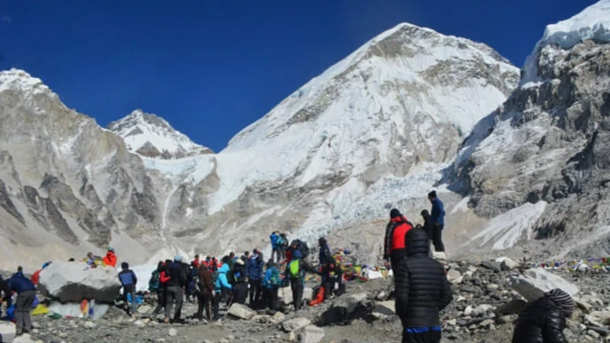
Over-tourism. The EBC trail during peak October is crowded, hundreds of trekkers per day on the busiest sections, queues at suspension bridges, competition for teahouse rooms. The park has considered carrying capacity limits but has not implemented them. The economic dependence of the Sherpa communities on trekking tourism makes restrictions politically and socially difficult.
What You Can Do
The trekker's contribution to Sagarmatha National Park is both financial (the permit fee) and behavioural. The behavioural contribution matters more.
Carry a reusable water bottle and use purification, every plastic bottle you do not buy is one that does not end up behind a teahouse at 4,900 metres. Stay on the trail, the alpine vegetation above the tree line is fragile and recovers slowly from trampling. Do not feed wildlife. Do not collect plants, rocks, or fossils. Respect the mani walls and prayer flags, walk clockwise around them, do not sit on them, and do not remove the stones.
And look. Look at the mountains, the glaciers, the forests, the birds, the yaks, the prayer flags, the river, the sky. The looking is not trivial. The park exists because people believed that this landscape deserved protection, and the looking, the conscious, attentive, grateful looking, is the validation of that belief. Every trekker who walks through Sagarmatha National Park and sees not just a trail to Everest but an ecosystem worth preserving is a trekker who justifies the park's existence.
The sixty-eight dollars you paid at Monjo bought a permit. What you do with it, how you walk, what you carry, what you leave behind, and what you notice, determines whether the permit purchased access or participation. The park needs both. The mountains deserve both.
All treks in the Everest region pass through Sagarmatha National Park. The entry permit is included in all our Everest packages, from the classic 12-day EBC Trek to the Three Passes Trek and the Gokyo Lakes Trek.
Sagarmatha National Park is not just Everest. It is Lhotse, Nuptse, Ama Dablam, Cho Oyu, and Makalu. It is the Khumbu Glacier, the Sherpa villages, the highest monastery in the world at Tengboche, and the musk deer hiding in the rhododendron forests below Namche. The park fee is $68 and it covers some of the most extraordinary terrain on the planet.
All our Everest region treks pass through Sagarmatha National Park. The entry fee is included in every package.
WhatsApp:+977 9810351300
Email:[email protected]
Written by Shreejan Simkhada, CEO of The Everest Holiday and third-generation Himalayan guide. TAAN Member #1586.
Sagarmatha National Park is our EBC home. Our Everest Base Camp Trek (12 Days) is private (your group only, no strangers), 2026 dates open, From USD $1399. WhatsApp us for tailored 2026 dates and current departures.