How high is Shyala village on the Manaslu Circuit?
You've been walking through forest all morning. The trail from Lho climbed through blue pine and rhododendron, the canopy overhead filtering the light into dappled patterns on the stone path, the Budhi Gandaki somewhere below, heard but not seen, its roar softened by the trees between you and the gorge. Your guide set a steady pace. The altitude was gaining quietly, three thousand metres, then three thousand two hundred, then three thousand three hundred, and you felt it in the slight shortness of breath on the steeper sections, the way your lungs asked for more air than the air could give. But the forest was comforting. Enclosed. Warm, even. It felt like the lower gorge still had a hold on you, like the mountains above were still hiding behind the canopy.
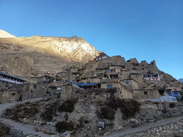
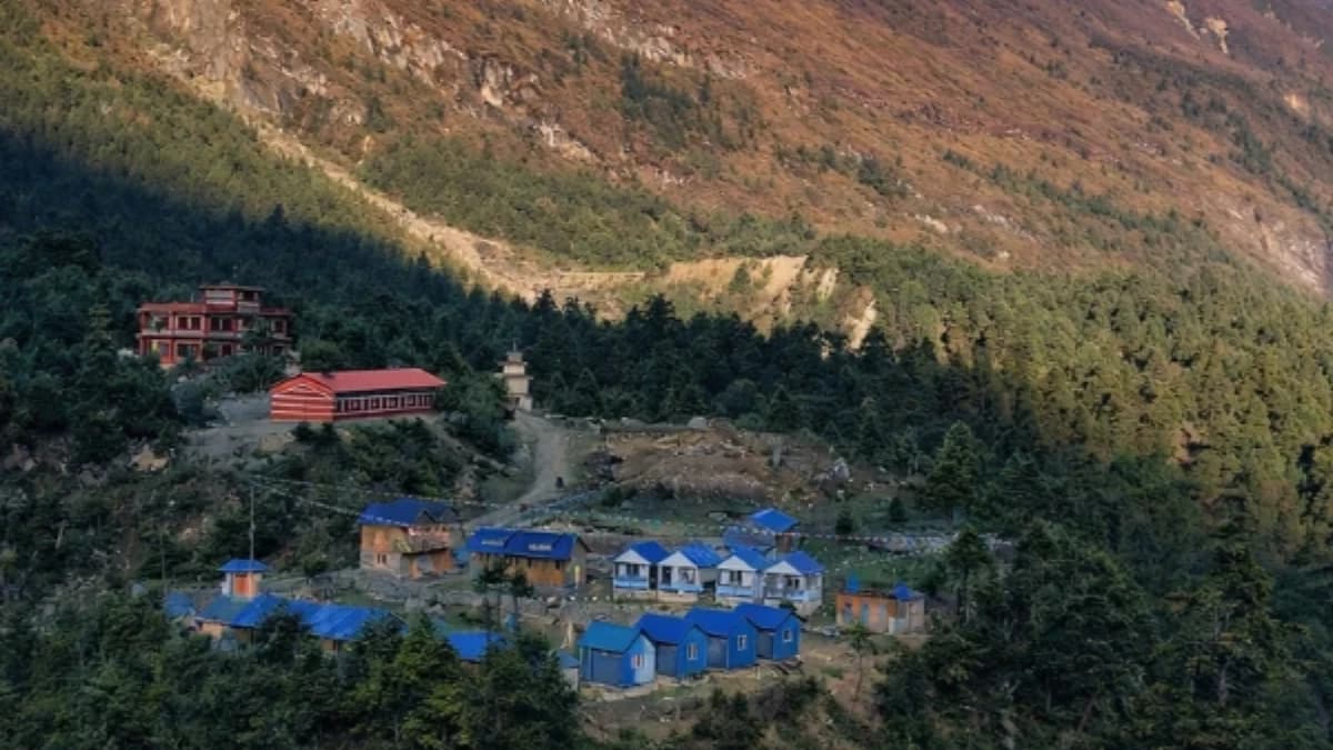
And then the trees thin. The rhododendrons shrink from tall canopy to stunted bush. The blue pines space themselves apart, and between them you see sky where there was only leaf, and then rock, and then snow, and then a summit so high above you that your neck aches from looking up. Manaslu. Not the full mountain, not yet, that comes at Samagaon, but the first honest, unobstructed glimpse of the eighth highest peak on earth, framed between the last of the forest and the first of the alpine. You've crossed a threshold. The trees know it. The air knows it. And Shyala, the tiny settlement where you've stopped for the night, a handful of stone buildings on a shelf above the river at 3,500 metres, knows it too.
Shyala is the village where the Manaslu Circuit's landscape changes character. Below here is forest. Above here is alpine. And Shyala sits precisely on the line between them, a settlement so small that most maps mark it as a dot, most itineraries mention it as a passing name, and most trekkers walk through without stopping. Those who do stop discover something that the larger villages on the circuit cannot offer: the quiet of a place that exists at the margin of two worlds, where the last trees meet the first high pastures, and where the mountain that gives this circuit its name finally steps forward from behind the ridges and shows itself.
What Is the Settlement at Shyala Like?
Call it a village and you've already exaggerated. Shyala, also spelled Shyaula on some maps and permit documents, is a settlement of perhaps five or six stone houses and one or two teahouses that serve the trekkers passing through the upper Budhi Gandaki valley. There is no monastery here. No school. No shop beyond what the teahouse kitchen stocks. The permanent population is measured in families, not hundreds, and in winter, when the snow closes the upper valley and the trekking season ends, even those families may move to lower ground.
The houses are stone-walled, with flat roofs in the Tibetan style that dominates every settlement above Namrung. Firewood is stacked against the walls in quantities that speak to the length and severity of winter at this altitude. Prayer flags fly from every rooftop and from poles at the settlement's edges, their colours faded by the sun and wind that are stronger here than in the protected gorge below. A mani wall runs along the trail through the settlement, carved prayer stones, each inscribed with Om Mani Padme Hum, worn smooth by the hands and weather of decades. Walk on the left side. Keep the wall to your right. This is not a suggestion.
The teahouses at Shyala are basic. A common room with a stove. A kitchen. A handful of rooms with wooden beds, foam mattresses, and blankets that you'll supplement with your sleeping bag. The menu is the standard Manaslu Circuit fare, dal bhat, noodle soup, fried rice, Tibetan bread, and tea in quantities that the altitude makes necessary. The facilities are simpler than at Lho below or Samagaon above. But the stove is warm, the food is hot, and the teahouse owner, who has carried or arranged the carrying of every item in the kitchen from the roadhead days below, will welcome you with the hospitality that remote altitude settlements practise as a matter of survival, not commerce.
How Does the Landscape Change at Shyala?
The most interesting thing about Shyala, if you pay attention to the landscape rather than just walk through it, is the treeline. Not a line in the strict sense, treelines never are, but a transition zone that Shyala sits precisely in the middle of, and that tells a story about altitude, climate, and the limits of what can grow where.
Below Shyala, the slopes carry blue pine and Himalayan fir. The rhododendrons, which put on their famous display of pink and red blooms in April and May, grow to the height of small trees, their trunks twisted and their branches heavy. The undergrowth is thick: bamboo, nettle, wild rose, and the specific tangle of alpine herbs that traditional Nepali and Tibetan medicine has catalogueued for centuries. The forest floor is soft with accumulated needles and leaf litter. Birdsong fills the canopy. The air smells of resin and damp earth.
At Shyala, the rhododendrons have shrunk. They're still present, growing as bushes rather than trees, their leaves smaller and tougher, adapted to the harsher conditions of increased altitude. The blue pines are thinner, shorter, spaced further apart. Between them, the ground cover shifts to juniper, dwarf shrubs, and the hardy grasses that will dominate the landscape from here to the Larkya La pass. Lichen covers the exposed rock faces in shades of orange, green, and grey, the first colonisers of the bare stone that altitude exposes when the trees give up.
Above Shyala, the forest disappears entirely within an hour's walking. The alpine zone begins, open pastures of brown and gold grass, scattered boulders left by retreating glaciers, and the occasional stunted juniper bush that clings to a sheltered spot between rocks. The change is not gradual from a trekker's perspective. You walk through forest, then scrub, then open ground, and you can almost point to the spot where the last tree stands. That spot is near Shyala. The village marks the boundary between the green world below and the brown world above, and standing at the edge of the settlement looking up the valley, you can see both worlds at once, the forest behind you, the alpine ahead, and Manaslu presiding over both.
Can you see Manaslu from Shyala village?
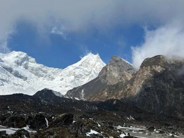
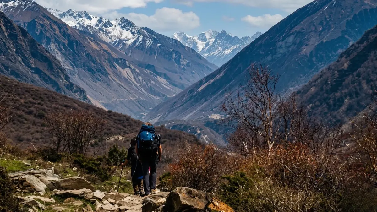
The Manaslu Circuit earns its name slowly. For the first three or four days, Manaslu is invisible, hidden behind the gorge walls, behind intermediate ridges, behind the forest canopy that closes over the trail. At Namrung, the mountains begin to appear, but Manaslu itself is still only a suggestion. At Lho, the view improves, the village's hilltop monastery offers a partial view of the summit ridge. But it's at Shyala, where the trees thin and the valley begins to open northward, that Manaslu starts to reveal itself with something approaching honesty.
From the trail above Shyala, looking north up the Budhi Gandaki valley, you can see the massive glaciated flanks of Manaslu (8,163 metres) rising above the intervening ridges. The view is not the full, close panorama that Samagaon delivers, you're still a day's walk south, and the mountain is partially obscured by the valley's curve. But it's the first view that communicates scale. The first view where the summit is not a triangle above a ridge but a massive presence that dominates the entire northern horizon. The glaciers are visible, not as white dots but as textured ice fields that catch the light differently at different times of day. The summit ridge, often carrying a plume of wind-driven snow, is visible above everything.
To the east, the Himalchuli range fills the skyline, a wall of peaks that you've been seeing since Namrung but that becomes more dramatic as you gain altitude and the angle changes. To the west, the Budhi Gandaki valley's western wall rises in steep, forested slopes that give way to rock and then to snow. The valley at Shyala is broad enough to see all of this without craning your neck. The sky is bigger here than in the gorge below. The mountains are closer. And the sense of being surrounded, gently, not oppressively, by some of the highest terrain on earth begins to settle into your awareness in a way that the gorge, with its narrow views and roaring river, did not allow.
What wildlife can you see around Shyala village?
The transition zone around Shyala, where forest meets alpine, is one of the most productive wildlife habitats on the Manaslu Circuit. The edge between two ecosystems is always richer than either ecosystem alone, and the forest-alpine boundary near Shyala is no exception.
Himalayan tahr, stocky, sure-footed wild goats with curved horns and thick brown coats, inhabit the steep slopes above the treeline. They're most often seen in the early morning, grazing on the alpine grasses above the settlement before the sun warms the slopes and they retreat to the shade of rock overhangs. Look at the rocky terrain above Shyala, particularly on the eastern slopes where the morning sun hits first. The tahr are not shy exactly, but they're alert, a herd will watch you from a distance, assess you as non-threatening, and continue grazing. Stop walking and use binoculars if you have them.
Blue sheep, bharal, the iconic ungulate of the trans-Himalayan zone, are possible at Shyala's altitude, though they're more commonly sighted at higher elevations between Samagaon and Samdo. Blue sheep are not blue. They're grey-brown with a blue-grey sheen to their winter coat that gives them their name. They move across steep, open ground with a casual confidence that defies the angle of the slope, and they're best spotted on the bare hillsides above the treeline where their grey coats blend with the rock.
In the forest below Shyala, Himalayan monal pheasants, Nepal's national bird, flash iridescent green, purple, and copper plumage through the undergrowth. The males are spectacularly coloured and surprisingly large, and they're most active in the early morning when the forest trail from Lho passes through their habitat. Daphne birds (white-capped redstarts), rosy finches, and various species of laughingthrush move through the scrub around the settlement. Ravens, large, intelligent, and vocal, patrol the valley at all altitudes, their croaking calls echoing off the rock walls above.
The transition zone also supports the less visible wildlife that sustains the visible, pikas (small, round-eared relatives of rabbits) live in the rock piles above the treeline, and their alarm calls, a sharp, high whistle, are one of the characteristic sounds of the alpine zone. Marmots, though more common on the northern side of the Larkya La, are occasionally present. And the predators that the prey species imply, snow leopard territory begins above the treeline on the Manaslu Circuit, are present in theory if not in practice. You will not see a snow leopard. But your guide may point to tracks in the dust above Shyala and tell you that one passed through recently, and the knowledge that you're walking through snow leopard habitat adds a dimension to the landscape that the scenery alone does not convey.
What is the culture like in Shyala village?
Shyala sits within the Nubri cultural zone, the Tibetan-heritage region that extends from approximately Namrung northward through Lho, Samagaon, and Samdo. The people of the upper Budhi Gandaki valley are ethnically and culturally Tibetan. Their language is a Tibetan dialect called Nubri. Their religion is Nyingma Buddhism, the oldest school of Tibetan Buddhism, associated with Guru Rinpoche and characterised by a rich tradition of ritual, meditation, and the integration of pre-Buddhist Bon practices that gives Himalayan Buddhism its distinctive character.
At Shyala, the Tibetan cultural influence is visible in the architecture (flat roofs, thick stone walls, prayer flags), in the mani walls that line the trail, and in the chortens, Buddhist reliquary structures, that mark the trail's passage through and around the settlement. The chortens at Shyala are simple whitewashed structures, smaller and less ornate than those at Samagaon or Samdo, but they serve the same purpose: marking sacred space, guiding the faithful along the trail, and reminding every passerby, trekker and local alike, that this landscape is not neutral ground but sacred geography.
The people at Shyala, like their neighbours at Lho and Samagaon, traditionally combined subsistence agriculture with livestock herding and trade. Barley and potatoes grow at this altitude in the brief summer season. Yaks graze the alpine pastures above the settlement in summer and are brought down in winter. The trans-Himalayan salt trade, which once moved salt and wool south from Tibet in exchange for grain and goods from the lowlands, sustained these settlements for centuries before the Chinese border restrictions of the mid-twentieth century disrupted the traditional economy.
Today, the trekking economy has partially replaced the trade economy. The teahouses at Shyala exist because trekkers walk this trail between September and November, and again in March and May. The families who run them supplement trekking income with agriculture and livestock, a mixed economy that the altitude and remoteness demand. The trekking season's income must sustain the family through the off-season months when the trail is empty, the passes are closed, and the settlement sits in the deep quiet of a Himalayan winter at 3,500 metres.
How long is the walk from Lho to Shyala?
The trail from Lho (3,180 metres) to Shyala (3,500 metres) takes approximately two to two and a half hours of steady walking. The altitude gain is modest, 320 metres, and the trail is well-defined, climbing gradually through forest before opening into the scrub zone around Shyala. The walking is not difficult by Manaslu Circuit standards, but the altitude is now above 3,000 metres, and the body's response to reduced oxygen means that what would be a casual walk at sea level requires measured effort here.
The trail passes through some of the circuit's most beautiful forest, blue pine and Himalayan fir with a rhododendron understory that, in spring (late April to mid-May), blooms in reds and pinks that set the entire hillside alight. In autumn (October to November), the forest is quieter, the leaves have turned gold and brown, the undergrowth has dried, and the light filtering through the thinning canopy is warm and amber. The trail crosses several small streams, side tributaries of the Budhi Gandaki, on wooden bridges or stepping stones. The river itself is below and to the right, its sound a constant companion that grows quieter as you gain altitude and the valley broadens.
Mani walls and chortens mark the trail at intervals. The prayer flags strung between trees, which began appearing at Namrung and increased at Lho, are continuous here, fluttering in the wind that funnels up the valley from the south. The trail passes through yak pastures where the animals, large, shaggy, and entirely indifferent to your presence, graze on the tough grasses that grow between the thinning trees. Your guide will walk on the uphill side of the yaks. You should do the same. They're docile but large, and being on the downhill side of a yak on a narrow trail is an experience best avoided.
How long is the walk from Shyala to Samagaon?
From Shyala to Samagaon (3,530 metres) is approximately two to three hours of walking, a gentle day that gains only thirty metres of altitude and that many trekkers combine with the Lho-to-Shyala section to make a single four-to-five-hour day from Lho to Samagaon. The trail follows the Budhi Gandaki valley northward, climbing gradually through the alpine zone that begins above Shyala.
The character of the walk changes after Shyala. The forest is behind you. The trail crosses open ground, yak pastures, stone-strewn hillsides, and the broad valley floor where the river braids across a gravel bed that expands and contracts with the seasons. The views open dramatically. Manaslu's glaciated flanks dominate the northern horizon with increasing proximity and detail. The valley walls, stripped of their forest cover, reveal the geological layers, folded, fractured, and tilted, that tell the story of the collision between the Indian and Eurasian tectonic plates that built these mountains.
The approach to Samagaon is memorable. The trail rounds a broad curve in the valley and the village appears, two hundred houses spread across a terrace above the river, prayer flags on every roof, the monastery of Pungyen Gompa visible on the hillside above. After the small settlements of the middle valley, Namrung, Lho, Shyala, Samagaon feels almost urban. But that's the contrast talking. In any other context, Samagaon is a small, remote village at 3,530 metres. On the Manaslu Circuit, after days in the gorge and the forest, it's a capital.
Why Should You Stay Overnight at Shyala?
Most Manaslu Circuit itineraries schedule the walk from Lho to Samagaon as a single day, four to five hours of walking with a lunch stop at Shyala. This is perfectly manageable for fit trekkers with good acclimatisation. But there are reasons to consider spending a night at Shyala rather than pushing through to Samagaon.
The first reason is altitude management. You've been gaining altitude steadily since Soti Khola or Machha Khola, and by the time you reach Lho (3,180 metres), you're above the threshold where acute mountain sickness becomes a possibility. Adding an extra night at 3,500 metres, between Lho (3,180 metres) and Samagaon (3,530 metres), gives your body additional time to acclimatise before the harder days above Samagaon. This is especially valuable for trekkers who are feeling the altitude's effects, who haven't trekked at high altitude before, or who are following a conservative acclimatisation schedule that prioritises safety over speed.
The second reason is the setting. Shyala's position at the treeline, the border between forest and alpine, creates a particular atmosphere that the larger villages above and below don't share. The quiet is deeper here. The teahouse has fewer trekkers. The evening, spent around the common room stove with your guide, perhaps one other trekking group, and the teahouse family, has an intimacy that the larger teahouses at Samagaon, where fifteen or twenty trekkers gather, cannot replicate.
The third reason is the morning. Sunrise at Shyala illuminates the valley above in gold while the forest below remains in shadow. The light climbs the slopes, touching the prayer flags first, then the stone walls, then the trail that disappears northward into the alpine. If you're staying the night and you're awake early, which at 3,500 metres you likely will be, because altitude disrupts sleep patterns and dawn arrives with a cold clarity that pulls you out of your sleeping bag, the morning light at Shyala is worth the extra day.
What Do You Need to Know About Shyala?
Altitude: Approximately 3,500 metres (11,480 feet). Above the altitude threshold for AMS. Drink at least three to four litres of water daily. Report headaches, nausea, or unusual fatigue to your guide immediately.
Walking times: Two to two and a half hours from Lho (3,180 metres). Two to three hours onward to Samagaon (3,530 metres). Total Lho to Samagaon via Shyala: four to five hours.
Accommodation: One or two basic teahouses. Twin rooms with foam mattresses. Bring your own sleeping bag, the blankets provided are supplementary at best. Common room with a wood or yak-dung stove. No hot showers. Charging facilities may be available for a small fee but don't rely on it, carry a power bank.
Food: Standard Manaslu Circuit menu, dal bhat, noodle soup (thukpa), fried rice, Tibetan bread, chapati, pancakes, tea, instant coffee. Prices are higher than in Kathmandu or the lower gorge, everything has been carried here on someone's back. Dal bhat is always the best value and the most reliable meal. Eat more than you think you need, your body is burning extra calories to acclimatise.
Water: Treat all water. Boiled water is available from teahouses for a fee. Purification tablets or a UV steriliser are lighter and cheaper over the course of the trek. The streams near Shyala are glacial-fed and clean-looking but should still be treated.
Weather: Temperatures at 3,500 metres vary dramatically. Daytime in the trekking season (October-November, March-May): 10 to 18 degrees Celsius in sunshine. Night: minus 5 to plus 5 degrees Celsius. Wind chill in the open valley above the treeline can make it feel significantly colder. Bring layers, a down jacket is essential for mornings and evenings.
Permits required: Manaslu Restricted Area Permit (currently USD 100 per person per week in peak season, USD 75 in low season) and Manaslu Conservation Area Permit (NPR 3,000). Both are arranged in advance, your trekking agency handles this. A TAAN-registered guide is mandatory for the Manaslu Circuit; solo trekking is not permitted in the restricted area.
Best months: October and November for stable weather and clear views. Late March through May for rhododendron blooms in the forest below Shyala and longer days. December through February is possible but cold, with snow likely above Shyala. June through September is monsoon, trails are wet, leeches are active in the forest zone, and the Larkya La may be impassable.
The Quiet Between Two Worlds
The Manaslu Circuit has its landmarks, the deep gorge below Deng, the monastery at Samagaon, the ice-bound crossing of the Larkya La. These are the moments that appear in photographs and trip reports, the places that trekkers name when they describe the route. Shyala is not one of those places. It's too small, too quiet, too easily passed through on the way to somewhere more dramatic.
But the circuit's character is not built only from its landmarks. It's built from the transitions between them, the moments when one landscape gives way to another, when the trail crosses an invisible line and the world changes. Shyala sits on one of those lines. Behind you, the forest, green, enclosed, fragrant with pine resin and the sound of birds. Ahead of you, the alpine, open, brown, wind-scoured, and dominated by mountains that are no longer hidden behind trees but standing in full view, close and impossibly high.
Between those two worlds, Shyala waits. A handful of stone houses. A mani wall. A teahouse with a warm stove and hot tea. And a view up the valley that promises everything the next five days of walking will deliver, Manaslu in full, the Larkya La in snow, and the specific, unrepeatable experience of walking a circuit around the eighth highest mountain on earth in a valley where the prayer flags outnumber the people and the quiet is so deep that the flapping of cloth in the wind sounds like conversation.
Shyala is on the Manaslu Circuit Trek, between Samagaon and the Larkya La base camp.
Shyala is the quietest place on the Manaslu Circuit. Two or three stone houses, one lodge, and a view that stretches all the way to Tibet. Most trekkers pass through in an hour. But if your acclimatisation schedule allows, staying the night is worth it. The stars at this altitude, with no light pollution for fifty kilometres in any direction, are extraordinary.
We include Shyala as an acclimatisation option on our Manaslu Circuit Trek. Your guide decides based on how your body is responding to the altitude.
WhatsApp:+977 9810351300
Email:[email protected]
Written by Shreejan Simkhada, CEO of The Everest Holiday and third-generation Himalayan guide. TAAN Member #1586.
Shyala is the rest-day perch on the Manaslu Circuit. Our Manaslu Circuit Trek (12 Days) is private (your group only, no strangers), 2026 dates open, From USD $799. WhatsApp us for tailored 2026 dates and current departures.
Continue planning your trek
This is one stop on the Manaslu Circuit trail. For the full route, read our complete Manaslu region guide. When you are ready for dates and prices, see the Manaslu Circuit Trek (12 days) or WhatsApp us directly. We reply personally.